Randonnée Marche Neung-sur-Beuvron - neung sur beuvron - Photo
 lecmic
lecmic

Utilisateur

© OpenStreetMap contributors
Longueur
Longueur
17,4 km
Altitude max
Altitude max
128 m
Dénivelé positif
Dénivelé positif
152 m
Km-Effort
Km-Effort  
19,4 km
Altitude min
Altitude min
92 m
Dénivelé négatif
Dénivelé négatif
156 m
Boucle
Boucle
Oui
Date de création :
2021-10-17 05:29:43.917
Dernière modification :
2021-10-17 08:45:20.752

(1 Avis)

Marche
Marche
3h14
Difficulté : Très facile

Scannez ce code QR pour ouvrir la randonnée dans l'application SityTrail

Application GPS de randonnée GRATUITE

Logo SityTrail SityTrail

IGN / Instituts géographiques

Télécharger SityTrail sur l'App Store Télécharger SityTrail sur Google Play

Logo SityTrail SityTrail World

Le monde est à vous

Télécharger SityTrail sur l'App Store Télécharger SityTrail sur Google Play Télécharger SityTrail sur Huawei AppGallery

À propos

Randonnée Marche de 17,4 km à découvrir à Centre-Val de Loire, Loir-et-Cher, Neung-sur-Beuvron. Cette randonnée est proposée par lecmic.

Description

octobre rose

Profil altimétrique

Localisation

Pays :
France
Région :
Centre-Val de Loire
Département/Province :
Loir-et-Cher
Commune :
Neung-sur-Beuvron
Localité :
Unknown
Départ:(UTM)
410137 ; 5265212 (31T) N.

Commentaires

Veuillez vous connecter pour laisser un commentaire ou une note


Randonnées à proximité

Randonnée Marche La Ferté-Beauharnais - LaFertéBeauharnais8-10-23 - Photo
Marche
annehc

Marche

Très difficile
La Ferté-Beauharnais, Centre-Val de Loire, Loir-et-Cher, France
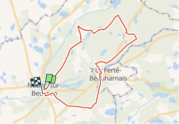
21 km | 23 km-effort
4h 16min
Oui
Randonnée Marche Neung-sur-Beuvron - neùng sur Beuvron  - Photo
Marche
lecmic

Marche

Très facile
Neung-sur-Beuvron, Centre-Val de Loire, Loir-et-Cher, France
12,3 km | 13,9 km-effort
3h 19min
Non
Randonnée A pied La Ferté-Beauharnais - La Ferté-Beauharnais-22-sept-2023 - Photo
A pied
boissay

A pied

Moyen
La Ferté-Beauharnais, Centre-Val de Loire, Loir-et-Cher, France
19 km | 21 km-effort
4h 50min
Oui
Randonnée A pied La Ferté-Beauharnais - La Ferté-Beauharnais-juin23 - Photo
A pied
boissay

A pied

Moyen
La Ferté-Beauharnais, Centre-Val de Loire, Loir-et-Cher, France
21 km | 24 km-effort
5h 27min
Oui
Randonnée Marche Neung-sur-Beuvron - La ferte beauharnais Ouest - Photo
Marche
lemuid

Marche

Très facile
Neung-sur-Beuvron, Centre-Val de Loire, Loir-et-Cher, France
12,4 km | 13,8 km-effort
2h 39min
Oui
Randonnée Marche Neung-sur-Beuvron - la Ferté Beauharnais - Neung sur Beuvron - Photo
Marche
lemuid

Marche

Très facile
Neung-sur-Beuvron, Centre-Val de Loire, Loir-et-Cher, France
9,7 km | 11,1 km-effort
1h 47min
Oui
Randonnée V.T.C. La Ferté-Beauharnais - boucle 17 sologne - Photo
V.T.C.
laurence41

V.T.C.

Très facile
La Ferté-Beauharnais, Centre-Val de Loire, Loir-et-Cher, France
39 km | 43 km-effort
2h 37min
Non
Randonnée A pied Neung-sur-Beuvron - Neung sur Beuvron / Montrieux en Sologne - Photo
A pied
danielwagner

A pied

Très facile
Neung-sur-Beuvron, Centre-Val de Loire, Loir-et-Cher, France
24 km | 26 km-effort
Inconnu
Oui
Randonnée A pied Neung-sur-Beuvron - Neung sur Beuvron 24 km - Photo
A pied
danielwagner

A pied

Moyen
Neung-sur-Beuvron, Centre-Val de Loire, Loir-et-Cher, France
24 km | 26 km-effort
Inconnu
Oui


Fermer
Mes abonnements