![](/images/other/stat-length.png)
![Randonnée A pied Peyrelevade - GR440, jour 6 Lieu de bivouac à Lieu de bivouac sommet herbeux - Photo](https://media.geolcdn.com/t/1900/400/ext.pjpeg?maxdim=2&url=https%3A%2F%2Fstatic1.geolcdn.com%2Fsiteimages%2Fupload%2Ffiles%2F1545311037marcheuse_200dpi.jpg)
GR440, jour 6 Lieu de bivouac à Lieu de bivouac sommet herbeux
MathieuBourgois
Utilisateur
![Longueur](/images/other/stat-length.png)
Longueur
26 km
![Altitude max](https://static1.geolcdn.com/siteimages/upload/files/1508320355ic_sort_altitude_max_24dp.png)
Altitude max
951 m
![Dénivelé positif](https://static1.geolcdn.com/siteimages/upload/files/1508320355ic_sort_den_pos_24dp.png)
Dénivelé positif
593 m
![Km-Effort](/images/other/stat-length.png)
Km-Effort
33 km
![Altitude min](https://static1.geolcdn.com/siteimages/upload/files/1508320355ic_sort_altitude_min_24dp.png)
Altitude min
756 m
![Dénivelé négatif](https://static1.geolcdn.com/siteimages/upload/files/1508320355ic_sort_den_neg_24dp.png)
Dénivelé négatif
483 m
![Boucle](https://static1.geolcdn.com/siteimages/upload/files/16400158638029165_repeat_loop_refresh_sync_direction_icon.png)
Boucle
Non
Date de création :
2021-10-14 09:40:08.377
Dernière modification :
2021-10-14 09:49:43.985
![A pied](https://static1.geolcdn.com/sitytour/trail-icons/100.png)
30m
Difficulté : Facile
![Scannez ce code QR pour ouvrir la randonnée dans l'application SityTrail](https://capi.geolives.com/qq0zvz2zws4bq2lad0pu/sitytour/trails/2969568/qr.png?size=200)
Application GPS de randonnée GRATUITE
À propos
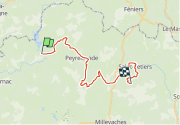
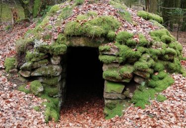
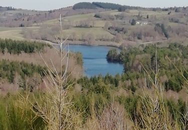
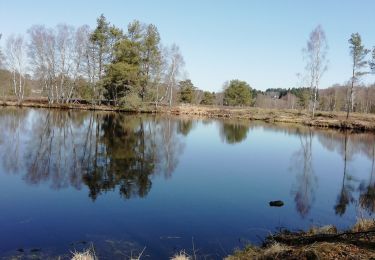
Randonnée A pied de 26 km à découvrir à Nouvelle-Aquitaine, Corrèze, Peyrelevade. Cette randonnée est proposée par MathieuBourgois.
Description
-Altitude max 951
-Ludinas 1.7km et 50D
-Négarioux 4km et 80D
-Peyrelevade 7.3km et 160D
-Croisement D36 18km et 450D
-Saint-Setiers 22km et 500D
-Sounaleix 25km et 580D
-Lieu de bivouac, sommet herbeux 26km et 590D
Localisation
Pays :
France
Région :
Nouvelle-Aquitaine
Département/Province :
Corrèze
Commune :
Peyrelevade
Localité :
Unknown
Départ:(Dec)
Départ:(UTM)
422150 ; 5062056 (31T) N.
Commentaires
Randonnées à proximité
![Randonnée V.T.T. Tarnac - VTT autour de Tarnac - Photo](https://media.geolcdn.com/t/375/260/43c7b44e-a85c-4560-bfd2-d07b69cc320c.jpg&format=jpg&maxdim=2)
![V.T.T. V.T.T.](https://static1.geolcdn.com/sitytour/trail-icons/202.png)
VTT autour de Tarnac
V.T.T.
Moyen
(1)
Tarnac,
Nouvelle-Aquitaine,
Corrèze,
France
![](/images/other/stat-length.png)
31 km | 44 km-effort
3h 1min
![](https://static1.geolcdn.com/siteimages/upload/files/16400158638029165_repeat_loop_refresh_sync_direction_icon.png)
Oui
![Randonnée Marche Peyrelevade - Fred La Mijoie éoliennes - Photo](https://media.geolcdn.com/t/375/260/19e53118-8e8e-489f-85a9-2b906555bb71.jpg&format=jpg&maxdim=2)
![Marche Marche](https://static1.geolcdn.com/sitytour/trail-icons/101.png)
Fred La Mijoie éoliennes
Marche
Difficile
Peyrelevade,
Nouvelle-Aquitaine,
Corrèze,
France
![](/images/other/stat-length.png)
14 km | 18,1 km-effort
3h 41min
![](https://static1.geolcdn.com/siteimages/upload/files/16400158638029165_repeat_loop_refresh_sync_direction_icon.png)
Oui
![Randonnée Marche Tarnac - Fred B C tarnac - Photo](https://media.geolcdn.com/t/375/260/83a33383-9149-4788-9b26-78c61f88f4e6.jpg&format=jpg&maxdim=2)
![Marche Marche](https://static1.geolcdn.com/sitytour/trail-icons/101.png)
Fred B C tarnac
Marche
Difficile
Tarnac,
Nouvelle-Aquitaine,
Corrèze,
France
![](/images/other/stat-length.png)
9,2 km | 12,7 km-effort
3h 29min
![](https://static1.geolcdn.com/siteimages/upload/files/16400158638029165_repeat_loop_refresh_sync_direction_icon.png)
Oui
![Randonnée Marche Tarnac - Fred BC Tarnac - Photo](https://media.geolcdn.com/t/375/260/b2b30376-855d-429d-8270-0bf948df158c.jpg&format=jpg&maxdim=2)
![Marche Marche](https://static1.geolcdn.com/sitytour/trail-icons/101.png)
Fred BC Tarnac
Marche
Difficile
Tarnac,
Nouvelle-Aquitaine,
Corrèze,
France
![](/images/other/stat-length.png)
10,1 km | 13,7 km-effort
3h 45min
![](https://static1.geolcdn.com/siteimages/upload/files/16400158638029165_repeat_loop_refresh_sync_direction_icon.png)
Oui
![Randonnée Marche Peyrelevade - Fred moulins et cabanes de Chamboux - Photo](https://media.geolcdn.com/t/375/260/a2f68e8f-ca07-47b7-981a-57b0aef34920.jpg&format=jpg&maxdim=2)
![Marche Marche](https://static1.geolcdn.com/sitytour/trail-icons/101.png)
Fred moulins et cabanes de Chamboux
Marche
Moyen
Peyrelevade,
Nouvelle-Aquitaine,
Corrèze,
France
![](/images/other/stat-length.png)
6,7 km | 8,7 km-effort
2h 6min
![](https://static1.geolcdn.com/siteimages/upload/files/16400158638029165_repeat_loop_refresh_sync_direction_icon.png)
Oui
![Randonnée Marche Peyrelevade - Fred lac du Chammet - Photo](https://media.geolcdn.com/t/375/260/357305a1-59e2-4f49-b168-027b2bc9ef25.jpg&format=jpg&maxdim=2)
![Marche Marche](https://static1.geolcdn.com/sitytour/trail-icons/101.png)
Fred lac du Chammet
Marche
Moyen
Peyrelevade,
Nouvelle-Aquitaine,
Corrèze,
France
![](/images/other/stat-length.png)
6,7 km | 8,7 km-effort
1h 52min
![](https://static1.geolcdn.com/siteimages/upload/files/16400158638029165_repeat_loop_refresh_sync_direction_icon.png)
Oui
![Randonnée Marche Peyrelevade - Fred les Fontaines de Cezeyrat - Photo](https://media.geolcdn.com/t/375/260/af49a6ff-a24d-422f-ad87-e0da40f8d002.jpg&format=jpg&maxdim=2)
![Marche Marche](https://static1.geolcdn.com/sitytour/trail-icons/101.png)
Fred les Fontaines de Cezeyrat
Marche
Difficile
Peyrelevade,
Nouvelle-Aquitaine,
Corrèze,
France
![](/images/other/stat-length.png)
10,3 km | 13,9 km-effort
3h 1min
![](https://static1.geolcdn.com/siteimages/upload/files/16400158638029165_repeat_loop_refresh_sync_direction_icon.png)
Oui
![Randonnée Marche Peyrelevade - Fred tourbière de negarioux malsagne - Photo](https://media.geolcdn.com/t/375/260/3263412b-f850-46d2-92b5-66d93c5f99cf.jpg&format=jpg&maxdim=2)
![Marche Marche](https://static1.geolcdn.com/sitytour/trail-icons/101.png)
Fred tourbière de negarioux malsagne
Marche
Moyen
Peyrelevade,
Nouvelle-Aquitaine,
Corrèze,
France
![](/images/other/stat-length.png)
6,2 km | 8 km-effort
1h 54min
![](https://static1.geolcdn.com/siteimages/upload/files/16400158638029165_repeat_loop_refresh_sync_direction_icon.png)
Oui
![Randonnée Marche Peyrelevade - Fred puy d auroc - Photo](https://media.geolcdn.com/t/375/260/a72adf5e-96ec-42bf-8879-b2bb5d44a472.jpg&format=jpg&maxdim=2)
![Marche Marche](https://static1.geolcdn.com/sitytour/trail-icons/101.png)
Fred puy d auroc
Marche
Difficile
Peyrelevade,
Nouvelle-Aquitaine,
Corrèze,
France
![](/images/other/stat-length.png)
9,9 km | 13,1 km-effort
2h 46min
![](https://static1.geolcdn.com/siteimages/upload/files/16400158638029165_repeat_loop_refresh_sync_direction_icon.png)
Oui