![](/images/other/stat-length.png)
![Randonnée Marche Fons-sur-Lussan - Fons sur Lussan Serre de Fons - Photo](https://media.geolcdn.com/t/1900/400/ext.pjpeg?maxdim=2&url=https%3A%2F%2Fstatic1.geolcdn.com%2Fsiteimages%2Fupload%2Ffiles%2F1553511878bg_sport_marche.png)
Fons sur Lussan Serre de Fons
Manoune
Utilisateur
![Longueur](/images/other/stat-length.png)
Longueur
12,1 km
![Altitude max](https://static1.geolcdn.com/siteimages/upload/files/1508320355ic_sort_altitude_max_24dp.png)
Altitude max
470 m
![Dénivelé positif](https://static1.geolcdn.com/siteimages/upload/files/1508320355ic_sort_den_pos_24dp.png)
Dénivelé positif
250 m
![Km-Effort](/images/other/stat-length.png)
Km-Effort
15,5 km
![Altitude min](https://static1.geolcdn.com/siteimages/upload/files/1508320355ic_sort_altitude_min_24dp.png)
Altitude min
292 m
![Dénivelé négatif](https://static1.geolcdn.com/siteimages/upload/files/1508320355ic_sort_den_neg_24dp.png)
Dénivelé négatif
250 m
![Boucle](https://static1.geolcdn.com/siteimages/upload/files/16400158638029165_repeat_loop_refresh_sync_direction_icon.png)
Boucle
Oui
Date de création :
2021-10-10 07:13:46.439
Dernière modification :
2021-10-14 13:14:41.336
![Marche](https://static1.geolcdn.com/sitytour/trail-icons/101.png)
4h43
Difficulté : Moyen
![Scannez ce code QR pour ouvrir la randonnée dans l'application SityTrail](https://capi.geolives.com/qq0zvz2zws4bq2lad0pu/sitytour/trails/2965651/qr.png?size=200)
Application GPS de randonnée GRATUITE
À propos
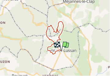
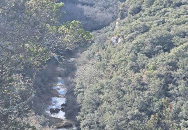
Randonnée Marche de 12,1 km à découvrir à Occitanie, Gard, Fons-sur-Lussan. Cette randonnée est proposée par Manoune.
Description
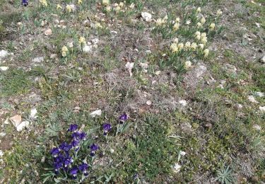
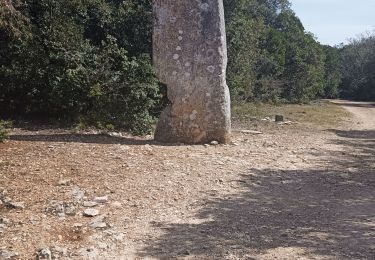
Départ parking du village, petite visite, cimetière, les Clos, Plaine Bernardin, Matte Aglans, Serre de Fons ( point de vue et pique - nique, petit retour sur nos pas , à gauche ,descente à la fontaine du Mas du Coq, D 187 , Guè, fin de la rando.
Localisation
Pays :
France
Région :
Occitanie
Département/Province :
Gard
Commune :
Fons-sur-Lussan
Localité :
Unknown
Départ:(Dec)
Départ:(UTM)
606260 ; 4893186 (31T) N.
Commentaires
Randonnées à proximité
![Randonnée Marche Lussan - 30 les concluses - Photo](https://media.geolcdn.com/t/375/260/ext.jpg?maxdim=2&url=https%3A%2F%2Fstatic1.geolcdn.com%2Fsiteimages%2Fupload%2Ffiles%2F1553511878bg_sport_marche.png)
![Marche Marche](https://static1.geolcdn.com/sitytour/trail-icons/101.png)
30 les concluses
Marche
Facile
(1)
Lussan,
Occitanie,
Gard,
France
![](/images/other/stat-length.png)
8 km | 11,1 km-effort
2h 24min
![](https://static1.geolcdn.com/siteimages/upload/files/16400158638029165_repeat_loop_refresh_sync_direction_icon.png)
Non
![Randonnée Marche Lussan - 30 conclused - Photo](https://media.geolcdn.com/t/375/260/3508400c-b3cc-4174-88e8-3293ce6735c5.jpg&format=jpg&maxdim=2)
![Marche Marche](https://static1.geolcdn.com/sitytour/trail-icons/101.png)
![Randonnée Marche Lussan - Concluses de Lussan - Photo](https://media.geolcdn.com/t/375/260/c22ae11d-0c26-4c10-b347-194805291eb0.jpg&format=jpg&maxdim=2)
![Marche Marche](https://static1.geolcdn.com/sitytour/trail-icons/101.png)
Concluses de Lussan
Marche
Difficile
Lussan,
Occitanie,
Gard,
France
![](/images/other/stat-length.png)
26 km | 0 m-effort
5h 46min
![](https://static1.geolcdn.com/siteimages/upload/files/16400158638029165_repeat_loop_refresh_sync_direction_icon.png)
Non
![Randonnée Marche Lussan - LUSSAN - LES CONCLUSES - 11.3 Km - 3h30 - Dénivelé 170 m - Photo](https://media.geolcdn.com/t/375/260/ext.jpg?maxdim=2&url=https%3A%2F%2Fstatic1.geolcdn.com%2Fsiteimages%2Fupload%2Ffiles%2F1553511878bg_sport_marche.png)
![Marche Marche](https://static1.geolcdn.com/sitytour/trail-icons/101.png)
LUSSAN - LES CONCLUSES - 11.3 Km - 3h30 - Dénivelé 170 m
Marche
Difficile
(2)
Lussan,
Occitanie,
Gard,
France
![](/images/other/stat-length.png)
11,3 km | 15 km-effort
3h 21min
![](https://static1.geolcdn.com/siteimages/upload/files/16400158638029165_repeat_loop_refresh_sync_direction_icon.png)
Oui
![Randonnée Marche Lussan - de Lussan aux Concluses - Photo](https://media.geolcdn.com/t/375/260/8a6775d5-5bb7-4b0e-8029-ae2fdb20db44.jpg&format=jpg&maxdim=2)
![Marche Marche](https://static1.geolcdn.com/sitytour/trail-icons/101.png)
de Lussan aux Concluses
Marche
Moyen
Lussan,
Occitanie,
Gard,
France
![](/images/other/stat-length.png)
15,8 km | 20 km-effort
5h 41min
![](https://static1.geolcdn.com/siteimages/upload/files/16400158638029165_repeat_loop_refresh_sync_direction_icon.png)
Oui
![Randonnée Marche Lussan - de Prades au Concluses - Photo](https://media.geolcdn.com/t/375/260/a90cee71-df80-4aad-96fe-a82f692c8692.jpg&format=jpg&maxdim=2)
![Marche Marche](https://static1.geolcdn.com/sitytour/trail-icons/101.png)
de Prades au Concluses
Marche
Moyen
Lussan,
Occitanie,
Gard,
France
![](/images/other/stat-length.png)
9,6 km | 12,9 km-effort
2h 48min
![](https://static1.geolcdn.com/siteimages/upload/files/16400158638029165_repeat_loop_refresh_sync_direction_icon.png)
Oui
![Randonnée Marche Rivières - 231203_Rivières - Photo](https://media.geolcdn.com/t/375/260/90c703ff-22cb-4a53-ba01-e199fc09b073.jpg&format=jpg&maxdim=2)
![Marche Marche](https://static1.geolcdn.com/sitytour/trail-icons/101.png)
231203_Rivières
Marche
Difficile
Rivières,
Occitanie,
Gard,
France
![](/images/other/stat-length.png)
15,4 km | 18,9 km-effort
5h 43min
![](https://static1.geolcdn.com/siteimages/upload/files/16400158638029165_repeat_loop_refresh_sync_direction_icon.png)
Oui
![Randonnée Marche Méjannes-le-Clap - mejannes le clap - Photo](https://media.geolcdn.com/t/375/260/d0e23ebe-33e3-4300-84fa-90d302ddb272.jpg&format=jpg&maxdim=2)
![Marche Marche](https://static1.geolcdn.com/sitytour/trail-icons/101.png)
mejannes le clap
Marche
Moyen
Méjannes-le-Clap,
Occitanie,
Gard,
France
![](/images/other/stat-length.png)
14,4 km | 19,3 km-effort
5h 19min
![](https://static1.geolcdn.com/siteimages/upload/files/16400158638029165_repeat_loop_refresh_sync_direction_icon.png)
Oui
![Randonnée Marche Lussan - randonnée Prades les concluses - Photo](https://media.geolcdn.com/t/375/260/d4984ccc-a1fa-4071-809d-8d283988038d.jpg&format=jpg&maxdim=2)
![Marche Marche](https://static1.geolcdn.com/sitytour/trail-icons/101.png)
randonnée Prades les concluses
Marche
Moyen
Lussan,
Occitanie,
Gard,
France
![](/images/other/stat-length.png)
11 km | 15,6 km-effort
3h 50min
![](https://static1.geolcdn.com/siteimages/upload/files/16400158638029165_repeat_loop_refresh_sync_direction_icon.png)
Oui