![](/images/other/stat-length.png)
![Randonnée Randonnée équestre Perl - Perl Villa Borg - Photo](https://media.geolcdn.com/t/1900/400/ext.pjpeg?maxdim=2&url=https%3A%2F%2Fstatic1.geolcdn.com%2Fsiteimages%2Fupload%2Ffiles%2F1524743154cheval.jpg)
Perl Villa Borg
claude-aei
Utilisateur
![Longueur](/images/other/stat-length.png)
Longueur
17,8 km
![Altitude max](https://static1.geolcdn.com/siteimages/upload/files/1508320355ic_sort_altitude_max_24dp.png)
Altitude max
422 m
![Dénivelé positif](https://static1.geolcdn.com/siteimages/upload/files/1508320355ic_sort_den_pos_24dp.png)
Dénivelé positif
306 m
![Km-Effort](/images/other/stat-length.png)
Km-Effort
22 km
![Altitude min](https://static1.geolcdn.com/siteimages/upload/files/1508320355ic_sort_altitude_min_24dp.png)
Altitude min
307 m
![Dénivelé négatif](https://static1.geolcdn.com/siteimages/upload/files/1508320355ic_sort_den_neg_24dp.png)
Dénivelé négatif
305 m
![Boucle](https://static1.geolcdn.com/siteimages/upload/files/16400158638029165_repeat_loop_refresh_sync_direction_icon.png)
Boucle
Oui
Date de création :
2021-10-10 08:22:40.459
Dernière modification :
2021-10-11 20:05:12.575
![Randonnée équestre](https://static1.geolcdn.com/sitytour/trail-icons/301.png)
3h45
Difficulté : Moyen
![Scannez ce code QR pour ouvrir la randonnée dans l'application SityTrail](https://capi.geolives.com/qq0zvz2zws4bq2lad0pu/sitytour/trails/2965615/qr.png?size=200)
Application GPS de randonnée GRATUITE
À propos
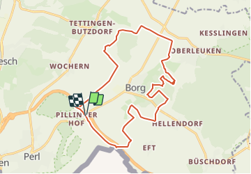
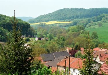
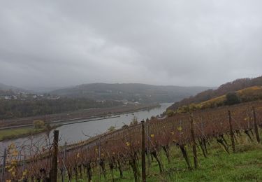
Randonnée Randonnée équestre de 17,8 km à découvrir à Sarre, Landkreis Merzig-Wadern, Perl. Cette randonnée est proposée par claude-aei.
Description
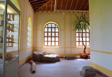
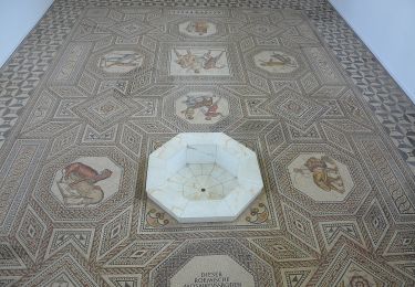
Belle balade par de beaux chemins, restaurant à la Villa Borg., possibilité d'attacher les chevaux à l'intérieur de la Villa
Localisation
Pays :
Allemagne
Région :
Sarre
Département/Province :
Landkreis Merzig-Wadern
Commune :
Perl
Localité :
Borg
Départ:(Dec)
Départ:(UTM)
312768 ; 5484815 (32U) N.
Commentaires
Randonnées à proximité
![Randonnée A pied Contz-les-Bains - Schengen grenzenlos / sans frontières - Photo](https://media.geolcdn.com/t/375/260/ext.jpg?maxdim=2&url=https%3A%2F%2Fmedia.geolcdn.com%2Ff%2F45497cda-a7e7-4df9-a6a1-692f43d5633d.jpeg)
![A pied A pied](https://static1.geolcdn.com/sitytour/trail-icons/100.png)
Schengen grenzenlos / sans frontières
A pied
Facile
Contz-les-Bains,
Grand Est,
Moselle,
France
![](/images/other/stat-length.png)
3,3 km | 4,6 km-effort
1h 3min
![](https://static1.geolcdn.com/siteimages/upload/files/16400158638029165_repeat_loop_refresh_sync_direction_icon.png)
Non
![Randonnée A pied Merschweiller - Circuit Apach-Waldwisse - Photo](https://media.geolcdn.com/t/375/260/ext.jpg?maxdim=2&url=https%3A%2F%2Fmedia.geolcdn.com%2Ff%2F3c410425-0585-4861-9a5d-9ca14274bc18.jpeg)
![A pied A pied](https://static1.geolcdn.com/sitytour/trail-icons/100.png)
Circuit Apach-Waldwisse
A pied
Facile
Merschweiller,
Grand Est,
Moselle,
France
![](/images/other/stat-length.png)
7,3 km | 10,5 km-effort
2h 22min
![](https://static1.geolcdn.com/siteimages/upload/files/16400158638029165_repeat_loop_refresh_sync_direction_icon.png)
Non
![Randonnée A pied Merschweiller - Promenade Circulaire d'Appach - Photo](https://media.geolcdn.com/t/375/260/ext.jpg?maxdim=2&url=https%3A%2F%2Fmedia.geolcdn.com%2Ff%2F3c410425-0585-4861-9a5d-9ca14274bc18.jpeg)
![A pied A pied](https://static1.geolcdn.com/sitytour/trail-icons/100.png)
Promenade Circulaire d'Appach
A pied
Facile
Merschweiller,
Grand Est,
Moselle,
France
![](/images/other/stat-length.png)
9,1 km | 13 km-effort
2h 57min
![](https://static1.geolcdn.com/siteimages/upload/files/16400158638029165_repeat_loop_refresh_sync_direction_icon.png)
Oui
![Randonnée A pied Apach - Saar-Hunsrück Steig Traumschleifen Panoramaweg Perl - Photo](https://media.geolcdn.com/t/375/260/ext.jpg?maxdim=2&url=https%3A%2F%2Fmedia.geolcdn.com%2Ff%2F2f051831-eb4c-430b-86d3-eeef60fb95da.jpeg)
![A pied A pied](https://static1.geolcdn.com/sitytour/trail-icons/100.png)
Saar-Hunsrück Steig Traumschleifen Panoramaweg Perl
A pied
Facile
Apach,
Grand Est,
Moselle,
France
![](/images/other/stat-length.png)
8,2 km | 11,4 km-effort
2h 35min
![](https://static1.geolcdn.com/siteimages/upload/files/16400158638029165_repeat_loop_refresh_sync_direction_icon.png)
Oui
![Randonnée A pied Manderen-Ritzing - Promenade Circulaire Manderen-Ritzing - Photo](https://media.geolcdn.com/t/375/260/ext.jpg?maxdim=2&url=https%3A%2F%2Fmedia.geolcdn.com%2Ff%2Fa57417a1-bfb7-4979-bb99-88cf1c8900c7.jpeg)
![A pied A pied](https://static1.geolcdn.com/sitytour/trail-icons/100.png)
Promenade Circulaire Manderen-Ritzing
A pied
Facile
Manderen-Ritzing,
Grand Est,
Moselle,
France
![](/images/other/stat-length.png)
9,1 km | 10,6 km-effort
2h 24min
![](https://static1.geolcdn.com/siteimages/upload/files/16400158638029165_repeat_loop_refresh_sync_direction_icon.png)
Non
![Randonnée A pied Manderen-Ritzing - Promenade Circulaire Manderen Merschweiler - Photo](https://media.geolcdn.com/t/375/260/ext.jpg?maxdim=2&url=https%3A%2F%2Fmedia.geolcdn.com%2Ff%2F3c410425-0585-4861-9a5d-9ca14274bc18.jpeg)
![A pied A pied](https://static1.geolcdn.com/sitytour/trail-icons/100.png)
Promenade Circulaire Manderen Merschweiler
A pied
Facile
Manderen-Ritzing,
Grand Est,
Moselle,
France
![](/images/other/stat-length.png)
5,6 km | 7,3 km-effort
1h 39min
![](https://static1.geolcdn.com/siteimages/upload/files/16400158638029165_repeat_loop_refresh_sync_direction_icon.png)
Non
![Randonnée A pied Perl - Dolinenweg - Photo](https://media.geolcdn.com/t/375/260/ext.jpg?maxdim=2&url=https%3A%2F%2Fmedia.geolcdn.com%2Ff%2Fa5871f3c-2f24-4ede-99bb-918d825bc40b.jpeg)
![A pied A pied](https://static1.geolcdn.com/sitytour/trail-icons/100.png)
Dolinenweg
A pied
Facile
Perl,
Sarre,
Landkreis Merzig-Wadern,
Allemagne
![](/images/other/stat-length.png)
7 km | 9,1 km-effort
2h 3min
![](https://static1.geolcdn.com/siteimages/upload/files/16400158638029165_repeat_loop_refresh_sync_direction_icon.png)
Oui
![Randonnée A pied Schengen - Sentier Grouf - Photo](https://media.geolcdn.com/t/375/260/ext.jpg?maxdim=2&url=https%3A%2F%2Fmedia.geolcdn.com%2Ff%2Feeb086f6-5a54-4928-a6cd-8cc9bb48fe81.jpeg)
![A pied A pied](https://static1.geolcdn.com/sitytour/trail-icons/100.png)
Sentier Grouf
A pied
Facile
Schengen,
Inconnu,
Canton Remich,
Luxembourg
![](/images/other/stat-length.png)
4,2 km | 5,6 km-effort
1h 15min
![](https://static1.geolcdn.com/siteimages/upload/files/16400158638029165_repeat_loop_refresh_sync_direction_icon.png)
Oui
![Randonnée Marche nordique Schengen - Etape 1 GR5 - E2 - Photo](https://media.geolcdn.com/t/375/260/ext.jpg?maxdim=2&url=https%3A%2F%2Fmedia.geolcdn.com%2Ff%2Fb4b91d50-d0e7-401f-8936-e17eb846540c.jpg)
![Marche nordique Marche nordique](https://static1.geolcdn.com/sitytour/trail-icons/102.png)
Etape 1 GR5 - E2
Marche nordique
Moyen
Schengen,
Inconnu,
Canton Remich,
Luxembourg
![](/images/other/stat-length.png)
30 km | 41 km-effort
7h 8min
![](https://static1.geolcdn.com/siteimages/upload/files/16400158638029165_repeat_loop_refresh_sync_direction_icon.png)
Non