![](/images/other/stat-length.png)
![Randonnée Marche Agde - Camping CAP d'AGDE Bagnas Mt St Lou et Mt St Martin - Photo](https://media.geolcdn.com/t/1900/400/1bec1ff2-0354-400a-9473-0a49ed5a0914.jpg&format=pjpeg&maxdim=2)
Camping CAP d'AGDE Bagnas Mt St Lou et Mt St Martin
jll7513
Utilisateur
![Longueur](/images/other/stat-length.png)
![Altitude max](https://static1.geolcdn.com/siteimages/upload/files/1508320355ic_sort_altitude_max_24dp.png)
![Dénivelé positif](https://static1.geolcdn.com/siteimages/upload/files/1508320355ic_sort_den_pos_24dp.png)
![Km-Effort](/images/other/stat-length.png)
![Altitude min](https://static1.geolcdn.com/siteimages/upload/files/1508320355ic_sort_altitude_min_24dp.png)
![Dénivelé négatif](https://static1.geolcdn.com/siteimages/upload/files/1508320355ic_sort_den_neg_24dp.png)
![Boucle](https://static1.geolcdn.com/siteimages/upload/files/16400158638029165_repeat_loop_refresh_sync_direction_icon.png)
![Marche](https://static1.geolcdn.com/sitytour/trail-icons/101.png)
2h55
Difficulté : Facile
![Marche nordique](https://static1.geolcdn.com/sitytour/trail-icons/102.png)
1h59
Difficulté : Facile
![Scannez ce code QR pour ouvrir la randonnée dans l'application SityTrail](https://capi.geolives.com/qq0zvz2zws4bq2lad0pu/sitytour/trails/2964437/qr.png?size=200)
Application GPS de randonnée GRATUITE
À propos
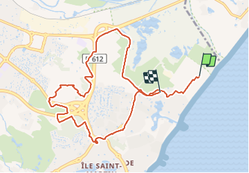
Randonnée Marche de 10,9 km à découvrir à Occitanie, Hérault, Agde. Cette randonnée est proposée par jll7513.
Description
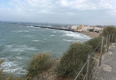
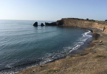
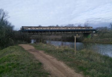
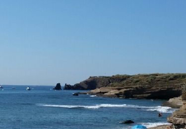
Parcours sympa au départ du camping naturiste du Cap d'Agde. Permet de longer la réserve du Bagnas et de faire un tour sur le mont Saint Loup de contourner le mont-Saint-Martin et de terminer en utilisant la passerelle du palais des congrès. À noter très beau point de vue du mont saint Loup et la présence de deux tables d'orientation. Le départ de la randonnée peut se faire aussi de l'extérieur du camping naturiste depuis le parking donner accès au parcours longeant la réserve du Bagnas.
Localisation
Commentaires
Randonnées à proximité
![Randonnée Marche Agde - CAP D'AGDE (Mont St-Martin et Mont Saint-Loup) - Photo](https://media.geolcdn.com/t/375/260/ext.jpg?maxdim=2&url=https%3A%2F%2Fservices.sitytrail.com%2FGeolivesWS%2FDownloadMedia.ashx%3FTrailID%3D1037029%26Media%3Dfix__20180909180025.jpg)
![Marche Marche](https://static1.geolcdn.com/sitytour/trail-icons/101.png)
Marche
![](/images/other/stat-length.png)
![](https://static1.geolcdn.com/siteimages/upload/files/16400158638029165_repeat_loop_refresh_sync_direction_icon.png)
![Randonnée Marche Marseillan - Marseillan - Photo](https://media.geolcdn.com/t/375/260/ext.jpg?maxdim=2&url=https%3A%2F%2Fservices.sitytrail.com%2FGeolivesWS%2FDownloadMedia.ashx%3FTrailID%3D105376%26Media%3D9077_5.jpg)
![Marche Marche](https://static1.geolcdn.com/sitytour/trail-icons/101.png)
Marche
![](/images/other/stat-length.png)
![](https://static1.geolcdn.com/siteimages/upload/files/16400158638029165_repeat_loop_refresh_sync_direction_icon.png)
![Randonnée Marche Agde - Agde à Vias par le canal du midi - Photo](https://media.geolcdn.com/t/375/260/ext.jpg?maxdim=2&url=https%3A%2F%2Fstatic1.geolcdn.com%2Fsiteimages%2Fupload%2Ffiles%2F1553511878bg_sport_marche.png)
![Marche Marche](https://static1.geolcdn.com/sitytour/trail-icons/101.png)
Marche
![](/images/other/stat-length.png)
![](https://static1.geolcdn.com/siteimages/upload/files/16400158638029165_repeat_loop_refresh_sync_direction_icon.png)
![Randonnée Marche Agde - Cap d’ Agde - Photo](https://media.geolcdn.com/t/375/260/a7ea19b7-1fb8-4d7d-a60a-f6479b0872d3.jpg&format=jpg&maxdim=2)
![Marche Marche](https://static1.geolcdn.com/sitytour/trail-icons/101.png)
![Randonnée V.T.T. Agde - Vtt pomerols Castelnau de Gers - Photo](https://media.geolcdn.com/t/375/260/98a5cf36-aaa5-4725-b0b7-b3e29396f73e.jpg&format=jpg&maxdim=2)
![V.T.T. V.T.T.](https://static1.geolcdn.com/sitytour/trail-icons/202.png)
V.T.T.
![](/images/other/stat-length.png)
![](https://static1.geolcdn.com/siteimages/upload/files/16400158638029165_repeat_loop_refresh_sync_direction_icon.png)
![Randonnée Marche Agde - Bellevue - Photo](https://media.geolcdn.com/t/375/260/44c5a702-85cc-49a3-9722-acda1b5c0604.jpg&format=jpg&maxdim=2)
![Marche Marche](https://static1.geolcdn.com/sitytour/trail-icons/101.png)
![Randonnée Marche Agde - agde. marseillan - Photo](https://media.geolcdn.com/t/375/260/ext.jpg?maxdim=2&url=https%3A%2F%2Fservices.sitytrail.com%2FGeolivesWS%2FDownloadMedia.ashx%3FTrailID%3D1090462%26Media%3Dd9b53375-574f-438a-9653-814c846eda22.jpg)
![Marche Marche](https://static1.geolcdn.com/sitytour/trail-icons/101.png)
Marche
![](/images/other/stat-length.png)
![](https://static1.geolcdn.com/siteimages/upload/files/16400158638029165_repeat_loop_refresh_sync_direction_icon.png)
![Randonnée Marche Agde - CAP d'AGDE (Par les falaises et plage de Rochelongue). - Photo](https://media.geolcdn.com/t/375/260/ext.jpg?maxdim=2&url=https%3A%2F%2Fservices.sitytrail.com%2FGeolivesWS%2FDownloadMedia.ashx%3FTrailID%3D1038071%26Media%3Dfix__20180911111407.jpg)
![Marche Marche](https://static1.geolcdn.com/sitytour/trail-icons/101.png)
Marche
![](/images/other/stat-length.png)
![](https://static1.geolcdn.com/siteimages/upload/files/16400158638029165_repeat_loop_refresh_sync_direction_icon.png)
![Randonnée Marche Agde - CAP D'AGDE ( Vers le Mont Saint - Loup) - Photo](https://media.geolcdn.com/t/375/260/ext.jpg?maxdim=2&url=https%3A%2F%2Fservices.sitytrail.com%2FGeolivesWS%2FDownloadMedia.ashx%3FTrailID%3D1036083%26Media%3Dfix__20180908105658.jpg)
![Marche Marche](https://static1.geolcdn.com/sitytour/trail-icons/101.png)
Marche
![](/images/other/stat-length.png)
![](https://static1.geolcdn.com/siteimages/upload/files/16400158638029165_repeat_loop_refresh_sync_direction_icon.png)