Randonnée V.T.T. Virton - 40km dans les bois de Virton  - Photo

40km dans les bois de Virton

 schreiber
schreiber

Utilisateur

© OpenStreetMap contributors
Longueur
Longueur
40 km
Altitude max
Altitude max
377 m
Dénivelé positif
Dénivelé positif
648 m
Km-Effort
Km-Effort  
48 km
Altitude min
Altitude min
202 m
Dénivelé négatif
Dénivelé négatif
649 m
Boucle
Boucle
Oui
Date de création :
2021-10-09 09:49:27.464
Dernière modification :
2021-10-09 10:29:52.401

(0 Avis)

V.T.T.
V.T.T.
3h20
Difficulté : Très difficile

Scannez ce code QR pour ouvrir la randonnée dans l'application SityTrail

Application GPS de randonnée GRATUITE

Logo SityTrail SityTrail

IGN / Instituts géographiques

Télécharger SityTrail sur l'App Store Télécharger SityTrail sur Google Play

Logo SityTrail SityTrail World

Le monde est à vous

Télécharger SityTrail sur l'App Store Télécharger SityTrail sur Google Play Télécharger SityTrail sur Huawei AppGallery

À propos

Randonnée V.T.T. de 40 km à découvrir à Wallonie, Luxembourg, Virton. Cette randonnée est proposée par schreiber.

Description

Randonnée vtt autour des points d'intérêts de la forêt de Virton, Vierge-Jacques, Zigomar, Bonlieu, Croix La Gardienne, Bois d'Ardennes, Trou des Fées, Gare de Buzenol, Chemin de l'épine, Laclaireau, gué de l'Ange-Gardien, Croix Renson, Fercol, cimetière militaire de Laclaireau, Ethe, ancienne gare de Bohé, Fagne de Pierrard, Chenois, Golf de Solumont

Profil altimétrique

Points d'intérêt

Point d'intérêt Virton - Douglas monumentaux - Photo
schreiber
Point d'intérêt Virton - Vierge Jacques - Photo
schreiber
Point d'intérêt Virton - Arboretum - Photo
schreiber
VIRTON 
Point d'intérêt Virton - Repaire des Zigomars - Photo
schreiber
Point d'intérêt Virton - Sentier des Songes - Photo
schreiber
Point d'intérêt Virton - Chapelle du Bonlieu - Photo
schreiber
Point d'intérêt Virton - Autel de la Morte-Femme - Photo
schreiber
Point d'intérêt Virton - Croix La Gardienne - Photo
schreiber
Point d'intérêt Virton - Chêne sur Loupe - Photo
schreiber
Point d'intérêt Virton - Trou des Fées - Photo
schreiber
Point d'intérêt Virton - Aire de Faulde - Photo
schreiber
Point d'intérêt Virton - Gué de l'Ange Gardien - Photo
schreiber
Point d'intérêt Virton - Croix Renson - Photo
schreiber
VIRTON 
Point d'intérêt Saint-Léger - Croix le Taureau - Photo
schreiber
SAINT-LÉGER 
Point d'intérêt Virton - Cimetière de Laclaireau - Photo
schreiber
Point d'intérêt Virton - Ravitaillement Boissons - Photo
schreiber

Localisation

Pays :
Belgique
Région :
Wallonie
Département/Province :
Luxembourg
Commune :
Virton
Localité :
Unknown
Départ:(UTM)
683094 ; 5492696 (31U) N.

Randonnées à proximité

Randonnée Marche Virton - RB-Lu-17_Ethe_via-var-1-et-2-et-3 - Photo
Marche
PRO

Marche

Très facile
(3)
Virton, Wallonie, Luxembourg, Belgique
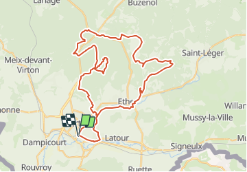
29 km | 35 km-effort
7h 33min
Oui
Randonnée V.T.T. Virton - Autour de Ethe  -  Balade_VTT_20kms - Photo
V.T.T.
Pascal L

V.T.T.

Facile
(1)
Virton, Wallonie, Luxembourg, Belgique
21 km | 26 km-effort
1h 40min
Oui
Randonnée Marche Virton - GAUME Balade  naturelle et historique - Photo
Marche
julucasi

Marche

Très facile
(1)
Virton, Wallonie, Luxembourg, Belgique
5,2 km | 6,8 km-effort
1h 16min
Oui
Randonnée A pied Virton - La Bajocienne - Photo
A pied
GUIDE+

A pied

Facile
(1)
Virton, Wallonie, Luxembourg, Belgique
11 km | 14,5 km-effort
3h 17min
Oui
Randonnée A pied Virton - Chenois-Latour Boucle agricole et touristique - Entre villages, pommes et petits fruits - Photo
A pied
GUIDE
DUPONT Rita

A pied

Facile
Virton, Wallonie, Luxembourg, Belgique
6,4 km | 7,7 km-effort
1h 45min
Oui
Randonnée Marche Virton - RB-Lu-17_Ethe_via-racc - Photo
Marche
PRO

Marche

Très facile
Virton, Wallonie, Luxembourg, Belgique
15,6 km | 19,3 km-effort
4h 8min
Oui
Randonnée Marche Virton - RB-Lu-17_Ethe - Photo
Marche
PRO

Marche

Très facile
Virton, Wallonie, Luxembourg, Belgique
22 km | 28 km-effort
5h 55min
Oui
Randonnée Cheval Rouvroy - rallye 2014 - Photo
Cheval
christianegabriel

Cheval

Moyen
(1)
Rouvroy, Wallonie, Luxembourg, Belgique
26 km | 32 km-effort
4h 1min
Oui
Randonnée V.T.T. Virton - Autour de Tintigny  -  Balade_VTT_54Kms - Photo
V.T.T.
Pascal L

V.T.T.

Très difficile
Virton, Wallonie, Luxembourg, Belgique
54 km | 64 km-effort
4h 25min
Oui


Fermer
Mes abonnements