![](/images/other/stat-length.png)
![Randonnée Marche Cavalaire-sur-Mer - Fenouillet Les Pradels - Photo](https://media.geolcdn.com/t/1900/400/ext.pjpeg?maxdim=2&url=https%3A%2F%2Fstatic1.geolcdn.com%2Fsiteimages%2Fupload%2Ffiles%2F1553511878bg_sport_marche.png)
Fenouillet Les Pradels
PhL83
Utilisateur
![Longueur](/images/other/stat-length.png)
Longueur
13,1 km
![Altitude max](https://static1.geolcdn.com/siteimages/upload/files/1508320355ic_sort_altitude_max_24dp.png)
Altitude max
350 m
![Dénivelé positif](https://static1.geolcdn.com/siteimages/upload/files/1508320355ic_sort_den_pos_24dp.png)
Dénivelé positif
496 m
![Km-Effort](/images/other/stat-length.png)
Km-Effort
19,7 km
![Altitude min](https://static1.geolcdn.com/siteimages/upload/files/1508320355ic_sort_altitude_min_24dp.png)
Altitude min
13 m
![Dénivelé négatif](https://static1.geolcdn.com/siteimages/upload/files/1508320355ic_sort_den_neg_24dp.png)
Dénivelé négatif
480 m
![Boucle](https://static1.geolcdn.com/siteimages/upload/files/16400158638029165_repeat_loop_refresh_sync_direction_icon.png)
Boucle
Non
Date de création :
2021-10-07 07:23:52.0
Dernière modification :
2021-10-08 15:46:30.721
![Marche](https://static1.geolcdn.com/sitytour/trail-icons/101.png)
5h38
Difficulté : Très difficile
![Scannez ce code QR pour ouvrir la randonnée dans l'application SityTrail](https://capi.geolives.com/qq0zvz2zws4bq2lad0pu/sitytour/trails/2961329/qr.png?size=200)
Application GPS de randonnée GRATUITE
À propos
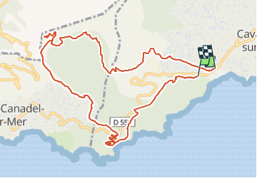
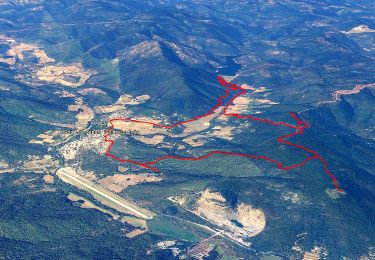
Randonnée Marche de 13,1 km à découvrir à Provence-Alpes-Côte d'Azur, Var, Cavalaire-sur-Mer. Cette randonnée est proposée par PhL83.
Description
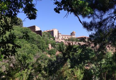
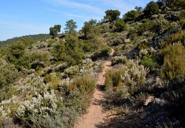
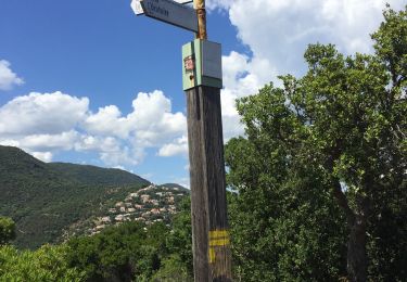
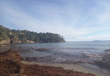
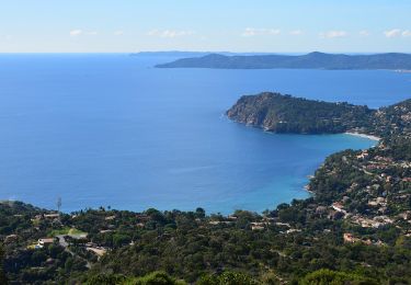
Belle randonnée en partant de Cavalaire près de la plage de Bonporteau. Elle permet ensuite de gagner les crêtes du Rayol Canadel et d'offrir de superbes panoramas sur la mer tant vers l'Est que l'Ouest et les Iles d'Or.
Localisation
Pays :
France
Région :
Provence-Alpes-Côte d'Azur
Département/Province :
Var
Commune :
Cavalaire-sur-Mer
Localité :
Unknown
Départ:(Dec)
Départ:(UTM)
298121 ; 4782233 (32T) N.
Commentaires
Randonnées à proximité
![Randonnée Marche La Môle - Barrage - Guiols - Chapelle Ste Magdeleine - Sommet Maravieille - Photo](https://media.geolcdn.com/t/375/260/0ba0349d-6bb2-4249-b45a-746244491cb5.jpg&format=jpg&maxdim=2)
![Marche Marche](https://static1.geolcdn.com/sitytour/trail-icons/101.png)
Barrage - Guiols - Chapelle Ste Magdeleine - Sommet Maravieille
Marche
Moyen
(2)
La Môle,
Provence-Alpes-Côte d'Azur,
Var,
France
![](/images/other/stat-length.png)
15,3 km | 21 km-effort
6h 0min
![](https://static1.geolcdn.com/siteimages/upload/files/16400158638029165_repeat_loop_refresh_sync_direction_icon.png)
Oui
![Randonnée V.T.T. La Môle - VTT - La Mole - Barrage de La Verne - Chartreuse de La Verne - Capelude - Retour La Mole par les crêtes - Photo](https://media.geolcdn.com/t/375/260/977ec82e-6359-4a66-ab94-b782942b304d.jpg&format=jpg&maxdim=2)
![V.T.T. V.T.T.](https://static1.geolcdn.com/sitytour/trail-icons/202.png)
VTT - La Mole - Barrage de La Verne - Chartreuse de La Verne - Capelude - Ret...
V.T.T.
Difficile
La Môle,
Provence-Alpes-Côte d'Azur,
Var,
France
![](/images/other/stat-length.png)
34 km | 45 km-effort
4h 41min
![](https://static1.geolcdn.com/siteimages/upload/files/16400158638029165_repeat_loop_refresh_sync_direction_icon.png)
Oui
![Randonnée Marche Rayol-Canadel-sur-Mer - Le rayon canadel - Route des crètes - Photo](https://media.geolcdn.com/t/375/260/4e43ac4c-7667-474b-8d0a-9263d51cfdde.jpg&format=jpg&maxdim=2)
![Marche Marche](https://static1.geolcdn.com/sitytour/trail-icons/101.png)
Le rayon canadel - Route des crètes
Marche
Difficile
Rayol-Canadel-sur-Mer,
Provence-Alpes-Côte d'Azur,
Var,
France
![](/images/other/stat-length.png)
14,8 km | 24 km-effort
6h 0min
![](https://static1.geolcdn.com/siteimages/upload/files/16400158638029165_repeat_loop_refresh_sync_direction_icon.png)
Oui
![Randonnée Marche Rayol-Canadel-sur-Mer - 20190222 rayol canadel - Photo](https://media.geolcdn.com/t/375/260/ext.jpg?maxdim=2&url=https%3A%2F%2Fstatic1.geolcdn.com%2Fsiteimages%2Fupload%2Ffiles%2F1553511878bg_sport_marche.png)
![Marche Marche](https://static1.geolcdn.com/sitytour/trail-icons/101.png)
20190222 rayol canadel
Marche
Facile
(1)
Rayol-Canadel-sur-Mer,
Provence-Alpes-Côte d'Azur,
Var,
France
![](/images/other/stat-length.png)
8 km | 11,1 km-effort
2h 38min
![](https://static1.geolcdn.com/siteimages/upload/files/16400158638029165_repeat_loop_refresh_sync_direction_icon.png)
Oui
![Randonnée Marche Cavalaire-sur-Mer - Cavalaire 2 - Photo](https://media.geolcdn.com/t/375/260/66220656-f369-437d-a3c4-6a7ae56dd908.jpg&format=jpg&maxdim=2)
![Marche Marche](https://static1.geolcdn.com/sitytour/trail-icons/101.png)
Cavalaire 2
Marche
Difficile
Cavalaire-sur-Mer,
Provence-Alpes-Côte d'Azur,
Var,
France
![](/images/other/stat-length.png)
9,3 km | 13,6 km-effort
3h 5min
![](https://static1.geolcdn.com/siteimages/upload/files/16400158638029165_repeat_loop_refresh_sync_direction_icon.png)
Oui
![Randonnée Marche Cavalaire-sur-Mer - Langaste Peinier le Col des Tuiles et retour - Photo](https://media.geolcdn.com/t/375/260/ext.jpg?maxdim=2&url=https%3A%2F%2Fstatic1.geolcdn.com%2Fsiteimages%2Fupload%2Ffiles%2F1553511878bg_sport_marche.png)
![Marche Marche](https://static1.geolcdn.com/sitytour/trail-icons/101.png)
Langaste Peinier le Col des Tuiles et retour
Marche
Difficile
(1)
Cavalaire-sur-Mer,
Provence-Alpes-Côte d'Azur,
Var,
France
![](/images/other/stat-length.png)
9,7 km | 14 km-effort
3h 10min
![](https://static1.geolcdn.com/siteimages/upload/files/16400158638029165_repeat_loop_refresh_sync_direction_icon.png)
Oui
![Randonnée V.T.C. Rayol-Canadel-sur-Mer - Vélo le col du Canadel et Parc de Port Cros - Photo](https://media.geolcdn.com/t/375/260/f6923b94-ab5d-42bf-aac8-dcd63edeb7c2.jpg&format=jpg&maxdim=2)
![V.T.C. V.T.C.](https://static1.geolcdn.com/sitytour/trail-icons/203.png)
Vélo le col du Canadel et Parc de Port Cros
V.T.C.
Moyen
Rayol-Canadel-sur-Mer,
Provence-Alpes-Côte d'Azur,
Var,
France
![](/images/other/stat-length.png)
43 km | 53 km-effort
3h 28min
![](https://static1.geolcdn.com/siteimages/upload/files/16400158638029165_repeat_loop_refresh_sync_direction_icon.png)
Oui
![Randonnée Marche Rayol-Canadel-sur-Mer - Rayol 21.1.23 - Photo](https://media.geolcdn.com/t/375/260/94d35f60-4441-4919-856b-aad9de111be5.jpg&format=jpg&maxdim=2)
![Marche Marche](https://static1.geolcdn.com/sitytour/trail-icons/101.png)
Rayol 21.1.23
Marche
Facile
Rayol-Canadel-sur-Mer,
Provence-Alpes-Côte d'Azur,
Var,
France
![](/images/other/stat-length.png)
8,5 km | 13,1 km-effort
2h 44min
![](https://static1.geolcdn.com/siteimages/upload/files/16400158638029165_repeat_loop_refresh_sync_direction_icon.png)
Oui
![Marche Marche](https://static1.geolcdn.com/sitytour/trail-icons/101.png)
Plage du Bonporteau et du Rayol
Marche
Moyen
(1)
Cavalaire-sur-Mer,
Provence-Alpes-Côte d'Azur,
Var,
France
![](/images/other/stat-length.png)
16,6 km | 25 km-effort
4h 32min
![](https://static1.geolcdn.com/siteimages/upload/files/16400158638029165_repeat_loop_refresh_sync_direction_icon.png)
Oui