![](/images/other/stat-length.png)
![Randonnée Marche Allègre-les-Fumades - Château et côte d'Allègre via Chapelle St Saturnin - Photo](https://media.geolcdn.com/t/1900/400/d7d461d4-6dac-4e00-8f61-ec30457ee379.jpg&format=pjpeg&maxdim=2)
Château et côte d'Allègre via Chapelle St Saturnin
thibat
Utilisateur
![Longueur](/images/other/stat-length.png)
Longueur
7,4 km
![Altitude max](https://static1.geolcdn.com/siteimages/upload/files/1508320355ic_sort_altitude_max_24dp.png)
Altitude max
350 m
![Dénivelé positif](https://static1.geolcdn.com/siteimages/upload/files/1508320355ic_sort_den_pos_24dp.png)
Dénivelé positif
253 m
![Km-Effort](/images/other/stat-length.png)
Km-Effort
10,8 km
![Altitude min](https://static1.geolcdn.com/siteimages/upload/files/1508320355ic_sort_altitude_min_24dp.png)
Altitude min
145 m
![Dénivelé négatif](https://static1.geolcdn.com/siteimages/upload/files/1508320355ic_sort_den_neg_24dp.png)
Dénivelé négatif
253 m
![Boucle](https://static1.geolcdn.com/siteimages/upload/files/16400158638029165_repeat_loop_refresh_sync_direction_icon.png)
Boucle
Oui
Date de création :
2021-10-06 11:30:13.315
Dernière modification :
2021-10-06 17:10:23.42
![Marche](https://static1.geolcdn.com/sitytour/trail-icons/101.png)
2h32
Difficulté : Moyen
![Scannez ce code QR pour ouvrir la randonnée dans l'application SityTrail](https://capi.geolives.com/qq0zvz2zws4bq2lad0pu/sitytour/trails/2960542/qr.png?size=200)
Application GPS de randonnée GRATUITE
À propos
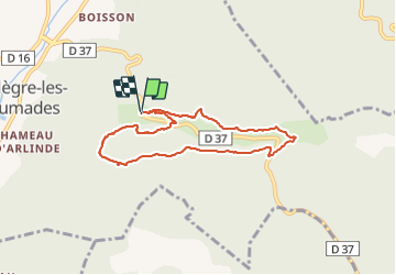
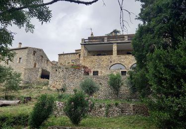
Randonnée Marche de 7,4 km à découvrir à Occitanie, Gard, Allègre-les-Fumades. Cette randonnée est proposée par thibat.
Description
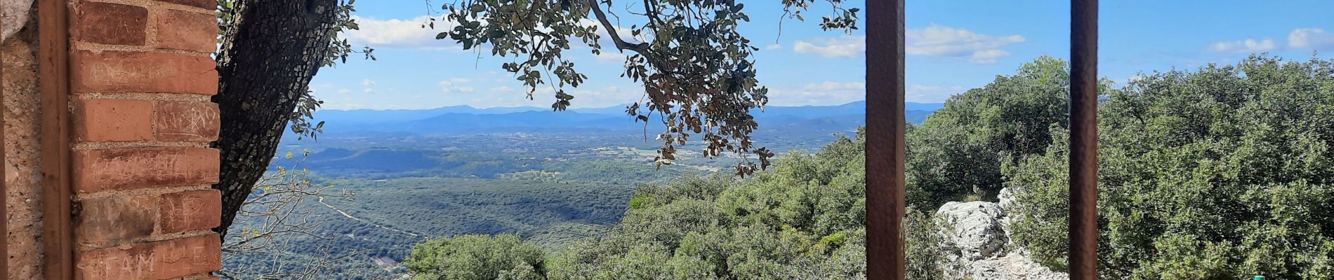
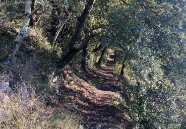
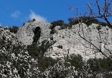
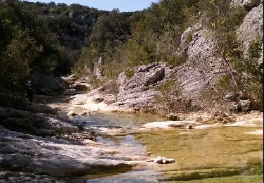
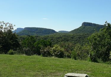
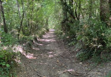
Rando au départ du parking du château d'Allègre empruntant la crête de la côte d'Allègre et le ravin de Serre Fourré. Nombreux points de vue sur la première partie de l'itinéraire.
Localisation
Pays :
France
Région :
Occitanie
Département/Province :
Gard
Commune :
Allègre-les-Fumades
Localité :
Unknown
Départ:(Dec)
Départ:(UTM)
600918 ; 4894509 (31T) N.
Commentaires
Randonnées à proximité
![Randonnée Marche Navacelles - Les Aiguiéres au départ de Call - Photo](https://media.geolcdn.com/t/375/260/ceda67ec-d101-468c-8a83-e91809d135cb.jpg&format=jpg&maxdim=2)
![Marche Marche](https://static1.geolcdn.com/sitytour/trail-icons/101.png)
Les Aiguiéres au départ de Call
Marche
Difficile
(1)
Navacelles,
Occitanie,
Gard,
France
![](/images/other/stat-length.png)
10,4 km | 14,9 km-effort
4h 39min
![](https://static1.geolcdn.com/siteimages/upload/files/16400158638029165_repeat_loop_refresh_sync_direction_icon.png)
Oui
![Randonnée Marche Allègre-les-Fumades - château d allègre aiguieres - Photo](https://media.geolcdn.com/t/375/260/c7f87895-b1c3-467b-937c-ecf963f10da2.jpg&format=jpg&maxdim=2)
![Marche Marche](https://static1.geolcdn.com/sitytour/trail-icons/101.png)
château d allègre aiguieres
Marche
Moyen
(1)
Allègre-les-Fumades,
Occitanie,
Gard,
France
![](/images/other/stat-length.png)
16,9 km | 25 km-effort
6h 10min
![](https://static1.geolcdn.com/siteimages/upload/files/16400158638029165_repeat_loop_refresh_sync_direction_icon.png)
Oui
![Randonnée Marche Navacelles - Aiguieres par Cal - Photo](https://media.geolcdn.com/t/375/260/ext.jpg?maxdim=2&url=https%3A%2F%2Fservices.sitytrail.com%2FGeolivesWS%2FDownloadMedia.ashx%3FTrailID%3D406963%26Media%3Dfix__20150412123451.jpg)
![Marche Marche](https://static1.geolcdn.com/sitytour/trail-icons/101.png)
Aiguieres par Cal
Marche
Moyen
(2)
Navacelles,
Occitanie,
Gard,
France
![](/images/other/stat-length.png)
8,9 km | 12,6 km-effort
2h 20min
![](https://static1.geolcdn.com/siteimages/upload/files/16400158638029165_repeat_loop_refresh_sync_direction_icon.png)
Oui
![Randonnée Marche Navacelles - Château d'Allegre / Aiguières - Photo](https://media.geolcdn.com/t/375/260/3f553ed7-1a33-4856-a98a-164e5181c4df.jpg&format=jpg&maxdim=2)
![Marche Marche](https://static1.geolcdn.com/sitytour/trail-icons/101.png)
Château d'Allegre / Aiguières
Marche
Difficile
Navacelles,
Occitanie,
Gard,
France
![](/images/other/stat-length.png)
20 km | 29 km-effort
7h 18min
![](https://static1.geolcdn.com/siteimages/upload/files/16400158638029165_repeat_loop_refresh_sync_direction_icon.png)
Oui
![Randonnée Marche Tharaux - Tharaux - Photo](https://media.geolcdn.com/t/375/260/01bc6044-7c62-4cc1-8831-f55311bb9329.jpg&format=jpg&maxdim=2)
![Marche Marche](https://static1.geolcdn.com/sitytour/trail-icons/101.png)
![Randonnée Marche Rochegude - ROCHEGUDE - GROTTE DES CAMISARDS - Photo](https://media.geolcdn.com/t/375/260/16497b10-8ac8-49c4-9447-7778ef028cc3.jpeg&format=jpg&maxdim=2)
![Marche Marche](https://static1.geolcdn.com/sitytour/trail-icons/101.png)
ROCHEGUDE - GROTTE DES CAMISARDS
Marche
Moyen
Rochegude,
Occitanie,
Gard,
France
![](/images/other/stat-length.png)
5 km | 7,6 km-effort
1h 43min
![](https://static1.geolcdn.com/siteimages/upload/files/16400158638029165_repeat_loop_refresh_sync_direction_icon.png)
Oui
![Randonnée Marche Rivières - 231203_Rivières - Photo](https://media.geolcdn.com/t/375/260/90c703ff-22cb-4a53-ba01-e199fc09b073.jpg&format=jpg&maxdim=2)
![Marche Marche](https://static1.geolcdn.com/sitytour/trail-icons/101.png)
231203_Rivières
Marche
Difficile
Rivières,
Occitanie,
Gard,
France
![](/images/other/stat-length.png)
15,4 km | 18,9 km-effort
5h 43min
![](https://static1.geolcdn.com/siteimages/upload/files/16400158638029165_repeat_loop_refresh_sync_direction_icon.png)
Oui
![Randonnée Marche Tharaux - Tharaux la Cèze - Photo](https://media.geolcdn.com/t/375/260/4bdb970c-b0f9-4e30-b3b2-4f135c4250be.jpg&format=jpg&maxdim=2)
![Marche Marche](https://static1.geolcdn.com/sitytour/trail-icons/101.png)
![Randonnée Marche Rochegude - Rochegude 30 - Photo](https://media.geolcdn.com/t/375/260/a538ea29-ca1c-4e49-a5d0-6fa2d1fad284.jpg&format=jpg&maxdim=2)
![Marche Marche](https://static1.geolcdn.com/sitytour/trail-icons/101.png)
Rochegude 30
Marche
Difficile
Rochegude,
Occitanie,
Gard,
France
![](/images/other/stat-length.png)
15,6 km | 21 km-effort
5h 42min
![](https://static1.geolcdn.com/siteimages/upload/files/16400158638029165_repeat_loop_refresh_sync_direction_icon.png)
Oui