Randonnée  Limours - Predecelle 2021 - GPX - Photo

Predecelle 2021 - GPX

 Gaby78
Gaby78

Utilisateur

© OpenStreetMap contributors
Longueur
Longueur
18,9 km
Altitude max
Altitude max
178 m
Dénivelé positif
Dénivelé positif
284 m
Km-Effort
Km-Effort  
23 km
Altitude min
Altitude min
88 m
Dénivelé négatif
Dénivelé négatif
287 m
Boucle
Boucle
Oui
Date de création :
2021-10-06 10:47:43.0
Dernière modification :
2021-10-06 10:47:44.452

(0 Avis)


Scannez ce code QR pour ouvrir la randonnée dans l'application SityTrail

Application GPS de randonnée GRATUITE

Logo SityTrail SityTrail

IGN / Instituts géographiques

Télécharger SityTrail sur l'App Store Télécharger SityTrail sur Google Play

Logo SityTrail SityTrail World

Le monde est à vous

Télécharger SityTrail sur l'App Store Télécharger SityTrail sur Google Play Télécharger SityTrail sur Huawei AppGallery

À propos

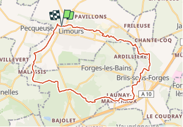
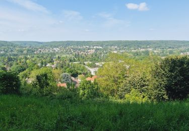
Randonnée de 18,9 km à découvrir à Île-de-France, Essonne, Limours. Cette randonnée est proposée par Gaby78.

Profil altimétrique

Localisation

Pays :
France
Région :
Île-de-France
Département/Province :
Essonne
Commune :
Limours
Localité :
Unknown
Départ:(Dec)
Départ:(UTM)
431449 ; 5388712 (31U) N.

Randonnées à proximité

Randonnée Marche Bonnelles - _Le rallye de Bonnelles à Rochefort - Photo
Marche
GUIDE+

Marche

Moyen
(10)
Bonnelles, Île-de-France, Yvelines, France
14,1 km | 16,4 km-effort
3h 30min
Oui
Randonnée Marche Choisel - _Si Choisel m'était conté - Photo
Marche
GUIDE+

Marche

Facile
(8)
Choisel, Île-de-France, Yvelines, France
5,6 km | 6,6 km-effort
1h 27min
Oui
Randonnée Marche Limours - Essonne_Tour_des_Fermes_de_la_Prédecelle - Photo
Marche
BMorin91470

Marche

Très facile
(1)
Limours, Île-de-France, Essonne, France
12,9 km | 14,3 km-effort
3h 43min
Oui
Randonnée Marche Limours - Essonne_RD_Limours=>Viaduc=>Prédecelle=>Chaumusson - Photo
Marche
BMorin91470

Marche

Facile
(1)
Limours, Île-de-France, Essonne, France
7,4 km | 8,4 km-effort
2h 30min
Oui
Randonnée Marche Limours - 20210319_Limours_Viaduc_Prédecelle_Amont - Photo
Marche
BMorin91470

Marche

Facile
(1)
Limours, Île-de-France, Essonne, France
8,7 km | 9,9 km-effort
2h 30min
Oui
Randonnée Marche Pecqueuse - 20191019_Tour_des_Fermes_réalisé - Photo
Marche
BMorin91470

Marche

Très facile
(1)
Pecqueuse, Île-de-France, Essonne, France
13,8 km | 15,2 km-effort
3h 43min
Oui
Randonnée V.T.T. Choisel - Rallye VTT de Choisel - Photo
V.T.T.
tracegps

V.T.T.

Très difficile
(1)
Choisel, Île-de-France, Yvelines, France
60 km | 75 km-effort
4h 0min
Oui
Randonnée Marche Gometz-le-Châtel - Gometz-le-Chatel.11022024 - Photo
Marche
aucamus

Marche

Moyen
(1)
Gometz-le-Châtel, Île-de-France, Essonne, France
17,9 km | 24 km-effort
5h 28min
Oui
Randonnée Marche Gif-sur-Yvette - Boucle Gif Sur Yvette 20 km - 370 mètres dénivelés - Photo
Marche
GUIDE
chessyca

Marche

Facile
Gif-sur-Yvette, Île-de-France, Essonne, France
21 km | 27 km-effort
5h 5min
Oui


Fermer
Mes abonnements