![](/images/other/stat-length.png)
![Randonnée Marche nordique Saint-Chéron - carrière Saint chérion - Photo](https://media.geolcdn.com/t/1900/400/7a5ccaf6-47ec-485d-b51b-aceb21d3f457.jpg&format=pjpeg&maxdim=2)
carrière Saint chérion
PascalROBINET
Utilisateur
![Longueur](/images/other/stat-length.png)
Longueur
10,3 km
![Altitude max](https://static1.geolcdn.com/siteimages/upload/files/1508320355ic_sort_altitude_max_24dp.png)
Altitude max
158 m
![Dénivelé positif](https://static1.geolcdn.com/siteimages/upload/files/1508320355ic_sort_den_pos_24dp.png)
Dénivelé positif
149 m
![Km-Effort](/images/other/stat-length.png)
Km-Effort
12,3 km
![Altitude min](https://static1.geolcdn.com/siteimages/upload/files/1508320355ic_sort_altitude_min_24dp.png)
Altitude min
65 m
![Dénivelé négatif](https://static1.geolcdn.com/siteimages/upload/files/1508320355ic_sort_den_neg_24dp.png)
Dénivelé négatif
149 m
![Boucle](https://static1.geolcdn.com/siteimages/upload/files/16400158638029165_repeat_loop_refresh_sync_direction_icon.png)
Boucle
Oui
Date de création :
2021-10-04 07:41:50.622
Dernière modification :
2021-10-15 09:27:10.407
![Marche nordique](https://static1.geolcdn.com/sitytour/trail-icons/102.png)
2h32
Difficulté : Très facile
![Scannez ce code QR pour ouvrir la randonnée dans l'application SityTrail](https://capi.geolives.com/qq0zvz2zws4bq2lad0pu/sitytour/trails/2958377/qr.png?size=200)
Application GPS de randonnée GRATUITE
À propos
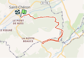
Randonnée Marche nordique de 10,3 km à découvrir à Île-de-France, Essonne, Saint-Chéron. Cette randonnée est proposée par PascalROBINET.
Description
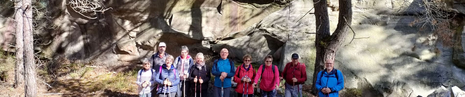
Cette marche nordique était conviviale, avec des temps de pause pour un intérêt historique du site. D'où la durée plus longue pour parcourir 10 kms avec une belle montée au départ.
Localisation
Pays :
France
Région :
Île-de-France
Département/Province :
Essonne
Commune :
Saint-Chéron
Localité :
Unknown
Départ:(Dec)
Départ:(UTM)
435449 ; 5377726 (31U) N.
Commentaires
Randonnées à proximité
![Randonnée Marche Saint-Sulpice-de-Favières - Les Pétales de Souzy - Photo](https://media.geolcdn.com/t/375/260/ext.jpg?maxdim=2&url=https%3A%2F%2Fservices.sitytrail.com%2FGeolivesWS%2FDownloadMedia.ashx%3FTrailID%3D110217%26Media%3D5477_1.jpg)
![Marche Marche](https://static1.geolcdn.com/sitytour/trail-icons/101.png)
Les Pétales de Souzy
Marche
Difficile
(1)
Saint-Sulpice-de-Favières,
Île-de-France,
Essonne,
France
![](/images/other/stat-length.png)
23 km | 29 km-effort
4h 49min
![](https://static1.geolcdn.com/siteimages/upload/files/16400158638029165_repeat_loop_refresh_sync_direction_icon.png)
Oui
![Randonnée A pied Saint-Sulpice-de-Favières - Boucle 18 km St Sulpice de Favières - Photo](https://media.geolcdn.com/t/375/260/d7c57897-6d36-438c-b5b4-66e9a4d71ed2.jpg&format=jpg&maxdim=2)
![A pied A pied](https://static1.geolcdn.com/sitytour/trail-icons/100.png)
Boucle 18 km St Sulpice de Favières
A pied
Moyen
Saint-Sulpice-de-Favières,
Île-de-France,
Essonne,
France
![](/images/other/stat-length.png)
18 km | 22 km-effort
4h 59min
![](https://static1.geolcdn.com/siteimages/upload/files/16400158638029165_repeat_loop_refresh_sync_direction_icon.png)
Oui
![Randonnée Marche Saint-Maurice-Montcouronne - Boucle St Maurice Montcouronne - Brigitte - Photo](https://media.geolcdn.com/t/375/260/0e3ebb94-9c16-4bc9-9efb-ddbb902c3347.jpg&format=jpg&maxdim=2)
![Marche Marche](https://static1.geolcdn.com/sitytour/trail-icons/101.png)
Boucle St Maurice Montcouronne - Brigitte
Marche
Très facile
Saint-Maurice-Montcouronne,
Île-de-France,
Essonne,
France
![](/images/other/stat-length.png)
21 km | 24 km-effort
4h 19min
![](https://static1.geolcdn.com/siteimages/upload/files/16400158638029165_repeat_loop_refresh_sync_direction_icon.png)
Oui
![Randonnée Marche Saint-Sulpice-de-Favières - St Sulpice - Photo](https://media.geolcdn.com/t/375/260/ext.jpg?maxdim=2&url=https%3A%2F%2Fstatic1.geolcdn.com%2Fsiteimages%2Fupload%2Ffiles%2F1553511878bg_sport_marche.png)
![Marche Marche](https://static1.geolcdn.com/sitytour/trail-icons/101.png)
St Sulpice
Marche
Moyen
(1)
Saint-Sulpice-de-Favières,
Île-de-France,
Essonne,
France
![](/images/other/stat-length.png)
8 km | 10,1 km-effort
2h 18min
![](https://static1.geolcdn.com/siteimages/upload/files/16400158638029165_repeat_loop_refresh_sync_direction_icon.png)
Oui
![Randonnée Marche Sermaise - 2018-09-26 Rando Sermaise - Photo](https://media.geolcdn.com/t/375/260/ext.jpg?maxdim=2&url=https%3A%2F%2Fstatic1.geolcdn.com%2Fsiteimages%2Fupload%2Ffiles%2F1553511878bg_sport_marche.png)
![Marche Marche](https://static1.geolcdn.com/sitytour/trail-icons/101.png)
2018-09-26 Rando Sermaise
Marche
Facile
(1)
Sermaise,
Île-de-France,
Essonne,
France
![](/images/other/stat-length.png)
12,3 km | 15 km-effort
3h 15min
![](https://static1.geolcdn.com/siteimages/upload/files/16400158638029165_repeat_loop_refresh_sync_direction_icon.png)
Oui
![Randonnée Marche Saint-Chéron - Saint-Cheron - l'Orge - Photo](https://media.geolcdn.com/t/375/260/2bdcf5f2-4f95-4613-9437-acb9feb0586a.jpg&format=jpg&maxdim=2)
![Marche Marche](https://static1.geolcdn.com/sitytour/trail-icons/101.png)
Saint-Cheron - l'Orge
Marche
Moyen
Saint-Chéron,
Île-de-France,
Essonne,
France
![](/images/other/stat-length.png)
8,3 km | 10,4 km-effort
2h 21min
![](https://static1.geolcdn.com/siteimages/upload/files/16400158638029165_repeat_loop_refresh_sync_direction_icon.png)
Oui
![Randonnée Marche Saint-Chéron - De Saint Chéron à Dourdan par les côteaux de la rive gauche - Photo](https://media.geolcdn.com/t/375/260/ext.jpg?maxdim=2&url=https%3A%2F%2Fstatic1.geolcdn.com%2Fsiteimages%2Fupload%2Ffiles%2F1553511878bg_sport_marche.png)
![Marche Marche](https://static1.geolcdn.com/sitytour/trail-icons/101.png)
De Saint Chéron à Dourdan par les côteaux de la rive gauche
Marche
Difficile
(1)
Saint-Chéron,
Île-de-France,
Essonne,
France
![](/images/other/stat-length.png)
13,5 km | 17 km-effort
3h 51min
![](https://static1.geolcdn.com/siteimages/upload/files/16400158638029165_repeat_loop_refresh_sync_direction_icon.png)
Non
![Randonnée Marche Villeconin - Villeconin - Photo](https://media.geolcdn.com/t/375/260/4c2738cd-d8e9-4cad-ac5e-3768674ab35a.jpg&format=jpg&maxdim=2)
![Marche Marche](https://static1.geolcdn.com/sitytour/trail-icons/101.png)
Villeconin
Marche
Moyen
Villeconin,
Île-de-France,
Essonne,
France
![](/images/other/stat-length.png)
8,5 km | 10,9 km-effort
2h 11min
![](https://static1.geolcdn.com/siteimages/upload/files/16400158638029165_repeat_loop_refresh_sync_direction_icon.png)
Oui
![Randonnée Marche Saint-Sulpice-de-Favières - Saint-Sulpice-de-Favières - Photo](https://media.geolcdn.com/t/375/260/30d6968b-6d8b-409a-a736-bd1e34a09395.jpg&format=jpg&maxdim=2)
![Marche Marche](https://static1.geolcdn.com/sitytour/trail-icons/101.png)
Saint-Sulpice-de-Favières
Marche
Moyen
Saint-Sulpice-de-Favières,
Île-de-France,
Essonne,
France
![](/images/other/stat-length.png)
7,5 km | 9,4 km-effort
1h 55min
![](https://static1.geolcdn.com/siteimages/upload/files/16400158638029165_repeat_loop_refresh_sync_direction_icon.png)
Oui