![](/images/other/stat-length.png)
![Randonnée Marche Nant - les canoles Pres de Nant - Photo](https://media.geolcdn.com/t/1900/400/ext.pjpeg?maxdim=2&url=https%3A%2F%2Fstatic1.geolcdn.com%2Fsiteimages%2Fupload%2Ffiles%2F1553511878bg_sport_marche.png)
les canoles Pres de Nant
nanie
Utilisateur
![Longueur](/images/other/stat-length.png)
Longueur
8,6 km
![Altitude max](https://static1.geolcdn.com/siteimages/upload/files/1508320355ic_sort_altitude_max_24dp.png)
Altitude max
757 m
![Dénivelé positif](https://static1.geolcdn.com/siteimages/upload/files/1508320355ic_sort_den_pos_24dp.png)
Dénivelé positif
132 m
![Km-Effort](/images/other/stat-length.png)
Km-Effort
10,3 km
![Altitude min](https://static1.geolcdn.com/siteimages/upload/files/1508320355ic_sort_altitude_min_24dp.png)
Altitude min
676 m
![Dénivelé négatif](https://static1.geolcdn.com/siteimages/upload/files/1508320355ic_sort_den_neg_24dp.png)
Dénivelé négatif
130 m
![Boucle](https://static1.geolcdn.com/siteimages/upload/files/16400158638029165_repeat_loop_refresh_sync_direction_icon.png)
Boucle
Oui
Date de création :
2021-10-02 19:53:11.119
Dernière modification :
2023-02-15 19:14:39.646
![Marche](https://static1.geolcdn.com/sitytour/trail-icons/101.png)
2h08
Difficulté : Très facile
![Scannez ce code QR pour ouvrir la randonnée dans l'application SityTrail](https://capi.geolives.com/qq0zvz2zws4bq2lad0pu/sitytour/trails/2956998/qr.png?size=200)
Application GPS de randonnée GRATUITE
À propos
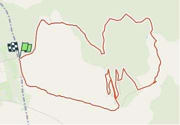
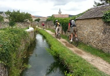
Randonnée Marche de 8,6 km à découvrir à Occitanie, Aveyron, Nant. Cette randonnée est proposée par nanie.
Description
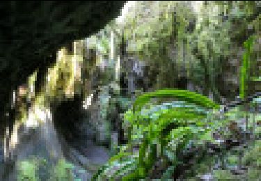
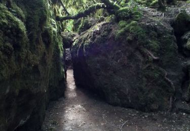
Sur le plateau du Larzac, l’érosion calcaire a creusé des canoles, étroites entailles rocheuses aux parois couvertes de mousse et de fougères. De véritables puits de fraîcheur dans leur écrin forestier.
Randonnée sans difficulté
Localisation
Pays :
France
Région :
Occitanie
Département/Province :
Aveyron
Commune :
Nant
Localité :
Unknown
Départ:(Dec)
Départ:(UTM)
518941 ; 4869442 (31T) N.
Commentaires
Randonnées à proximité
![Randonnée Marche Nant - les canalettes - Photo](https://media.geolcdn.com/t/375/260/ext.jpg?maxdim=2&url=https%3A%2F%2Fstatic1.geolcdn.com%2Fsiteimages%2Fupload%2Ffiles%2F1553511878bg_sport_marche.png)
![Marche Marche](https://static1.geolcdn.com/sitytour/trail-icons/101.png)
les canalettes
Marche
Facile
(1)
Nant,
Occitanie,
Aveyron,
France
![](/images/other/stat-length.png)
13,5 km | 15,6 km-effort
5h 21min
![](https://static1.geolcdn.com/siteimages/upload/files/16400158638029165_repeat_loop_refresh_sync_direction_icon.png)
Oui
![Randonnée Marche Nant - les canalettes - Photo](https://media.geolcdn.com/t/375/260/ext.jpg?maxdim=2&url=https%3A%2F%2Fstatic1.geolcdn.com%2Fsiteimages%2Fupload%2Ffiles%2F1553511878bg_sport_marche.png)
![Marche Marche](https://static1.geolcdn.com/sitytour/trail-icons/101.png)
![Randonnée Marche L'Hospitalet-du-Larzac - sources de Dourzon - Photo](https://media.geolcdn.com/t/375/260/ext.jpg?maxdim=2&url=https%3A%2F%2Fstatic1.geolcdn.com%2Fsiteimages%2Fupload%2Ffiles%2F1553511878bg_sport_marche.png)
![Marche Marche](https://static1.geolcdn.com/sitytour/trail-icons/101.png)
sources de Dourzon
Marche
Très facile
(1)
L'Hospitalet-du-Larzac,
Occitanie,
Aveyron,
France
![](/images/other/stat-length.png)
12,1 km | 15,8 km-effort
3h 23min
![](https://static1.geolcdn.com/siteimages/upload/files/16400158638029165_repeat_loop_refresh_sync_direction_icon.png)
Oui
![Randonnée Marche Nant - Descente des Canallettes à la source du Durzon - Photo](https://media.geolcdn.com/t/375/260/44818450-4921-42a2-b524-bbc3bda978cb.jpg&format=jpg&maxdim=2)
![Marche Marche](https://static1.geolcdn.com/sitytour/trail-icons/101.png)
Descente des Canallettes à la source du Durzon
Marche
Moyen
Nant,
Occitanie,
Aveyron,
France
![](/images/other/stat-length.png)
10,9 km | 14,5 km-effort
3h 17min
![](https://static1.geolcdn.com/siteimages/upload/files/16400158638029165_repeat_loop_refresh_sync_direction_icon.png)
Oui
![Randonnée Marche nordique Nant - Canoles du Larzac - Photo](https://media.geolcdn.com/t/375/260/e798f9be-ae1b-4eb5-8b2e-2008c29cb3a8.jpg&format=jpg&maxdim=2)
![Marche nordique Marche nordique](https://static1.geolcdn.com/sitytour/trail-icons/102.png)
Canoles du Larzac
Marche nordique
Très facile
(1)
Nant,
Occitanie,
Aveyron,
France
![](/images/other/stat-length.png)
8,4 km | 10,1 km-effort
4h 58min
![](https://static1.geolcdn.com/siteimages/upload/files/16400158638029165_repeat_loop_refresh_sync_direction_icon.png)
Oui
![Randonnée Marche Nant - Roc des Nantais - Photo](https://media.geolcdn.com/t/375/260/72d8a408-9af4-4099-8ab1-89441cf8187a.jpg&format=jpg&maxdim=2)
![Marche Marche](https://static1.geolcdn.com/sitytour/trail-icons/101.png)
![Randonnée Marche La Couvertoirade - la blaquererie (12) source du Dourzon par les canalettes - Photo](https://media.geolcdn.com/t/375/260/ext.jpg?maxdim=2&url=https%3A%2F%2Fstatic1.geolcdn.com%2Fsiteimages%2Fupload%2Ffiles%2F1553511878bg_sport_marche.png)
![Marche Marche](https://static1.geolcdn.com/sitytour/trail-icons/101.png)
la blaquererie (12) source du Dourzon par les canalettes
Marche
Moyen
(1)
La Couvertoirade,
Occitanie,
Aveyron,
France
![](/images/other/stat-length.png)
19,9 km | 26 km-effort
5h 21min
![](https://static1.geolcdn.com/siteimages/upload/files/16400158638029165_repeat_loop_refresh_sync_direction_icon.png)
Oui
![Randonnée V.T.T. La Couvertoirade - vtt larzac - Photo](https://media.geolcdn.com/t/375/260/ext.jpg?maxdim=2&url=https%3A%2F%2Fservices.sitytrail.com%2FGeolivesWS%2FDownloadMedia.ashx%3FTrailID%3D211519%26Media%3Dfix__20130808150345.jpg)
![V.T.T. V.T.T.](https://static1.geolcdn.com/sitytour/trail-icons/202.png)
vtt larzac
V.T.T.
Moyen
(1)
La Couvertoirade,
Occitanie,
Aveyron,
France
![](/images/other/stat-length.png)
30 km | 38 km-effort
3h 25min
![](https://static1.geolcdn.com/siteimages/upload/files/16400158638029165_repeat_loop_refresh_sync_direction_icon.png)
Non
![Randonnée Marche Nant - Sce du D'ourson Léa Cabanelles - Photo](https://media.geolcdn.com/t/375/260/a7bafac7-eae2-4108-b206-c7a9e5f271b0.jpg&format=jpg&maxdim=2)
![Marche Marche](https://static1.geolcdn.com/sitytour/trail-icons/101.png)
Sce du D'ourson Léa Cabanelles
Marche
Difficile
Nant,
Occitanie,
Aveyron,
France
![](/images/other/stat-length.png)
13,2 km | 17,4 km-effort
3h 48min
![](https://static1.geolcdn.com/siteimages/upload/files/16400158638029165_repeat_loop_refresh_sync_direction_icon.png)
Oui