![](/images/other/stat-length.png)
![Randonnée Marche Chamrousse - Belledonne Le Grand Sorbier - Photo](https://media.geolcdn.com/t/1900/400/ext.pjpeg?maxdim=2&url=https%3A%2F%2Fstatic1.geolcdn.com%2Fsiteimages%2Fupload%2Ffiles%2F1553511878bg_sport_marche.png)
Belledonne Le Grand Sorbier
c.gourme
Utilisateur
![Longueur](/images/other/stat-length.png)
Longueur
13,1 km
![Altitude max](https://static1.geolcdn.com/siteimages/upload/files/1508320355ic_sort_altitude_max_24dp.png)
Altitude max
2485 m
![Dénivelé positif](https://static1.geolcdn.com/siteimages/upload/files/1508320355ic_sort_den_pos_24dp.png)
Dénivelé positif
1081 m
![Km-Effort](/images/other/stat-length.png)
Km-Effort
28 km
![Altitude min](https://static1.geolcdn.com/siteimages/upload/files/1508320355ic_sort_altitude_min_24dp.png)
Altitude min
1680 m
![Dénivelé négatif](https://static1.geolcdn.com/siteimages/upload/files/1508320355ic_sort_den_neg_24dp.png)
Dénivelé négatif
1082 m
![Boucle](https://static1.geolcdn.com/siteimages/upload/files/16400158638029165_repeat_loop_refresh_sync_direction_icon.png)
Boucle
Oui
Date de création :
2021-09-28 06:07:36.0
Dernière modification :
2021-09-29 14:06:06.789
![Marche](https://static1.geolcdn.com/sitytour/trail-icons/101.png)
7h16
Difficulté : Moyen
![Scannez ce code QR pour ouvrir la randonnée dans l'application SityTrail](https://capi.geolives.com/qq0zvz2zws4bq2lad0pu/sitytour/trails/2952543/qr.png?size=200)
Application GPS de randonnée GRATUITE
À propos
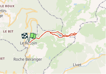
Randonnée Marche de 13,1 km à découvrir à Auvergne-Rhône-Alpes, Isère, Chamrousse. Cette randonnée est proposée par c.gourme.
Description
Ne pas rentrer par la Brèche sud. pas d'intérêt. Rentrer directement à droite du lac Robert direction Le Recoin
Localisation
Pays :
France
Région :
Auvergne-Rhône-Alpes
Département/Province :
Isère
Commune :
Chamrousse
Localité :
Unknown
Départ:(Dec)
Départ:(UTM)
726315 ; 5001024 (31T) N.
Commentaires
Randonnées à proximité
![Randonnée Marche Chamrousse - Boucle Roche Béranger - lacs Robert - Chamrousse - Photo](https://media.geolcdn.com/t/375/260/ext.jpg?maxdim=2&url=https%3A%2F%2Fservices.sitytrail.com%2FGeolivesWS%2FDownloadMedia.ashx%3FTrailID%3D172550%26Media%3D13915_2.jpg)
![Marche Marche](https://static1.geolcdn.com/sitytour/trail-icons/101.png)
Boucle Roche Béranger - lacs Robert - Chamrousse
Marche
Moyen
(1)
Chamrousse,
Auvergne-Rhône-Alpes,
Isère,
France
![](/images/other/stat-length.png)
11,4 km | 20 km-effort
4h 30min
![](https://static1.geolcdn.com/siteimages/upload/files/16400158638029165_repeat_loop_refresh_sync_direction_icon.png)
Oui
![Randonnée Ski de randonnée Chamrousse - col de la petite vaudaine - Photo](https://media.geolcdn.com/t/375/260/e327fe41-90ef-426f-99b9-61a7be1ec455.jpg&format=jpg&maxdim=2)
![Ski de randonnée Ski de randonnée](https://static1.geolcdn.com/sitytour/trail-icons/503.png)
col de la petite vaudaine
Ski de randonnée
Moyen
Chamrousse,
Auvergne-Rhône-Alpes,
Isère,
France
![](/images/other/stat-length.png)
15,4 km | 35 km-effort
7h 7min
![](https://static1.geolcdn.com/siteimages/upload/files/16400158638029165_repeat_loop_refresh_sync_direction_icon.png)
Oui
![Randonnée A pied Saint-Martin-d'Uriage - Circuit des Curistes - Photo](https://media.geolcdn.com/t/375/260/884736af-6d5e-4498-9816-404871d42486.jpeg&format=jpg&maxdim=2)
![A pied A pied](https://static1.geolcdn.com/sitytour/trail-icons/100.png)
Circuit des Curistes
A pied
Facile
Saint-Martin-d'Uriage,
Auvergne-Rhône-Alpes,
Isère,
France
![](/images/other/stat-length.png)
5,9 km | 7,8 km-effort
1h 46min
![](https://static1.geolcdn.com/siteimages/upload/files/16400158638029165_repeat_loop_refresh_sync_direction_icon.png)
Oui
![Randonnée A pied Saint-Martin-d'Uriage - Circuit des Crêtes - Photo](https://media.geolcdn.com/t/375/260/a077f9fa-48e4-483f-a273-f9f858afd6d0.jpeg&format=jpg&maxdim=2)
![A pied A pied](https://static1.geolcdn.com/sitytour/trail-icons/100.png)
Circuit des Crêtes
A pied
Facile
Saint-Martin-d'Uriage,
Auvergne-Rhône-Alpes,
Isère,
France
![](/images/other/stat-length.png)
9,5 km | 13,6 km-effort
3h 5min
![](https://static1.geolcdn.com/siteimages/upload/files/16400158638029165_repeat_loop_refresh_sync_direction_icon.png)
Oui
![Randonnée A pied Saint-Martin-d'Uriage - Circuit du Bit - Photo](https://media.geolcdn.com/t/375/260/2fa5dbdf-0fcb-48b8-a2a0-bdb0f129de25.jpeg&format=jpg&maxdim=2)
![A pied A pied](https://static1.geolcdn.com/sitytour/trail-icons/100.png)
Circuit du Bit
A pied
Facile
Saint-Martin-d'Uriage,
Auvergne-Rhône-Alpes,
Isère,
France
![](/images/other/stat-length.png)
9,1 km | 16,3 km-effort
3h 41min
![](https://static1.geolcdn.com/siteimages/upload/files/16400158638029165_repeat_loop_refresh_sync_direction_icon.png)
Oui
![Randonnée A pied Saint-Martin-d'Uriage - Balcon de Combeloup - Photo](https://media.geolcdn.com/t/375/260/67f211a9-4659-4ac8-8551-19ac88e52f68.jpeg&format=jpg&maxdim=2)
![A pied A pied](https://static1.geolcdn.com/sitytour/trail-icons/100.png)
Balcon de Combeloup
A pied
Facile
Saint-Martin-d'Uriage,
Auvergne-Rhône-Alpes,
Isère,
France
![](/images/other/stat-length.png)
9,4 km | 15,1 km-effort
3h 25min
![](https://static1.geolcdn.com/siteimages/upload/files/16400158638029165_repeat_loop_refresh_sync_direction_icon.png)
Oui
![Randonnée Marche Chamrousse - lacs Robert - Photo](https://media.geolcdn.com/t/375/260/ext.jpg?maxdim=2&url=https%3A%2F%2Fstatic1.geolcdn.com%2Fsiteimages%2Fupload%2Ffiles%2F1553511878bg_sport_marche.png)
![Marche Marche](https://static1.geolcdn.com/sitytour/trail-icons/101.png)
lacs Robert
Marche
Moyen
(1)
Chamrousse,
Auvergne-Rhône-Alpes,
Isère,
France
![](/images/other/stat-length.png)
9,2 km | 21 km-effort
5h 0min
![](https://static1.geolcdn.com/siteimages/upload/files/16400158638029165_repeat_loop_refresh_sync_direction_icon.png)
Oui
![Randonnée Marche Chamrousse - la grande moucherolle et la petite - Photo](https://media.geolcdn.com/t/375/260/e3dde858-ba24-405b-860c-373322d4b17f.jpg&format=jpg&maxdim=2)
![Marche Marche](https://static1.geolcdn.com/sitytour/trail-icons/101.png)
la grande moucherolle et la petite
Marche
Très difficile
Chamrousse,
Auvergne-Rhône-Alpes,
Isère,
France
![](/images/other/stat-length.png)
130 km | 170 km-effort
11h 33min
![](https://static1.geolcdn.com/siteimages/upload/files/16400158638029165_repeat_loop_refresh_sync_direction_icon.png)
Non
![Randonnée Marche Séchilienne - Lac de Luitel - Pic de l'oeilly - Photo](https://media.geolcdn.com/t/375/260/392243d2-0bef-4c0e-a978-68f4c5437966.jpg&format=jpg&maxdim=2)
![Marche Marche](https://static1.geolcdn.com/sitytour/trail-icons/101.png)
Lac de Luitel - Pic de l'oeilly
Marche
Facile
Séchilienne,
Auvergne-Rhône-Alpes,
Isère,
France
![](/images/other/stat-length.png)
7,3 km | 11,1 km-effort
2h 26min
![](https://static1.geolcdn.com/siteimages/upload/files/16400158638029165_repeat_loop_refresh_sync_direction_icon.png)
Oui