![](/images/other/stat-length.png)
![Randonnée Marche Emberménil - LES EVRIEUX - Photo](https://media.geolcdn.com/t/1900/400/ext.pjpeg?maxdim=2&url=https%3A%2F%2Fstatic1.geolcdn.com%2Fsiteimages%2Fupload%2Ffiles%2F1553511878bg_sport_marche.png)
LES EVRIEUX
DanielROLLET
Utilisateur
![Longueur](/images/other/stat-length.png)
Longueur
6,5 km
![Altitude max](https://static1.geolcdn.com/siteimages/upload/files/1508320355ic_sort_altitude_max_24dp.png)
Altitude max
324 m
![Dénivelé positif](https://static1.geolcdn.com/siteimages/upload/files/1508320355ic_sort_den_pos_24dp.png)
Dénivelé positif
95 m
![Km-Effort](/images/other/stat-length.png)
Km-Effort
7,7 km
![Altitude min](https://static1.geolcdn.com/siteimages/upload/files/1508320355ic_sort_altitude_min_24dp.png)
Altitude min
243 m
![Dénivelé négatif](https://static1.geolcdn.com/siteimages/upload/files/1508320355ic_sort_den_neg_24dp.png)
Dénivelé négatif
95 m
![Boucle](https://static1.geolcdn.com/siteimages/upload/files/16400158638029165_repeat_loop_refresh_sync_direction_icon.png)
Boucle
Oui
Date de création :
2021-09-26 06:56:37.763
Dernière modification :
2021-09-26 17:27:35.593
![Marche](https://static1.geolcdn.com/sitytour/trail-icons/101.png)
2h00
Difficulté : Facile
![Scannez ce code QR pour ouvrir la randonnée dans l'application SityTrail](https://capi.geolives.com/qq0zvz2zws4bq2lad0pu/sitytour/trails/2949941/qr.png?size=200)
Application GPS de randonnée GRATUITE
À propos
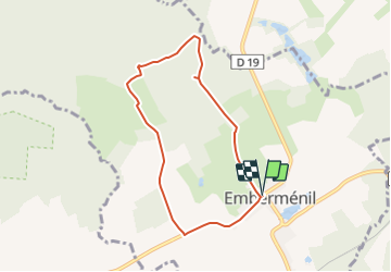
Randonnée Marche de 6,5 km à découvrir à Grand Est, Meurthe-et-Moselle, Emberménil. Cette randonnée est proposée par DanielROLLET.
Description
2021 09 16 - avec Marie - 09h00 à 11h00 - nombreux arrêts
Temps pluvieux mais calme
Reco pour CDSI ffRandonnée
Localisation
Pays :
France
Région :
Grand Est
Département/Province :
Meurthe-et-Moselle
Commune :
Emberménil
Localité :
Unknown
Départ:(Dec)
Départ:(UTM)
330201 ; 5388828 (32U) N.
Commentaires
Randonnées à proximité
![Randonnée Marche Reillon - Reillon (Les Entonnoirs) - Photo](https://media.geolcdn.com/t/375/260/ext.jpg?maxdim=2&url=https%3A%2F%2Fservices.sitytrail.com%2FGeolivesWS%2FDownloadMedia.ashx%3FTrailID%3D203419%26Media%3Dfix__20130707130623.jpg)
![Marche Marche](https://static1.geolcdn.com/sitytour/trail-icons/101.png)
Reillon (Les Entonnoirs)
Marche
Moyen
Reillon,
Grand Est,
Meurthe-et-Moselle,
France
![](/images/other/stat-length.png)
17,6 km | 21 km-effort
4h 27min
![](https://static1.geolcdn.com/siteimages/upload/files/16400158638029165_repeat_loop_refresh_sync_direction_icon.png)
Oui
![Randonnée Marche Reillon - Reillon, les Entonnoirs - Photo](https://media.geolcdn.com/t/375/260/ext.jpg?maxdim=2&url=https%3A%2F%2Fservices.sitytrail.com%2FGeolivesWS%2FDownloadMedia.ashx%3FTrailID%3D763687%26Media%3Dfix__20170527183256.jpg)
![Marche Marche](https://static1.geolcdn.com/sitytour/trail-icons/101.png)
Reillon, les Entonnoirs
Marche
Facile
Reillon,
Grand Est,
Meurthe-et-Moselle,
France
![](/images/other/stat-length.png)
8,1 km | 9,7 km-effort
1h 58min
![](https://static1.geolcdn.com/siteimages/upload/files/16400158638029165_repeat_loop_refresh_sync_direction_icon.png)
Oui
![Randonnée Randonnée équestre Emberménil - emberménil bénaménil - Photo](https://media.geolcdn.com/t/375/260/ext.jpg?maxdim=2&url=https%3A%2F%2Fstatic1.geolcdn.com%2Fsiteimages%2Fupload%2Ffiles%2F1524743154cheval.jpg)
![Randonnée équestre Randonnée équestre](https://static1.geolcdn.com/sitytour/trail-icons/301.png)
emberménil bénaménil
Randonnée équestre
Facile
Emberménil,
Grand Est,
Meurthe-et-Moselle,
France
![](/images/other/stat-length.png)
12,5 km | 14,3 km-effort
1h 52min
![](https://static1.geolcdn.com/siteimages/upload/files/16400158638029165_repeat_loop_refresh_sync_direction_icon.png)
Non
![Randonnée Marche Emberménil - Embermenil 6 470m +97m - Photo](https://media.geolcdn.com/t/375/260/ext.jpg?maxdim=2&url=https%3A%2F%2Fstatic1.geolcdn.com%2Fsiteimages%2Fupload%2Ffiles%2F1553511878bg_sport_marche.png)
![Marche Marche](https://static1.geolcdn.com/sitytour/trail-icons/101.png)
Embermenil 6 470m +97m
Marche
Moyen
Emberménil,
Grand Est,
Meurthe-et-Moselle,
France
![](/images/other/stat-length.png)
6,5 km | 7,8 km-effort
1h 45min
![](https://static1.geolcdn.com/siteimages/upload/files/16400158638029165_repeat_loop_refresh_sync_direction_icon.png)
Oui
![Randonnée Marche Vaucourt - vaucourt - Photo](https://media.geolcdn.com/t/375/260/ext.jpg?maxdim=2&url=https%3A%2F%2Fstatic1.geolcdn.com%2Fsiteimages%2Fupload%2Ffiles%2F1553511878bg_sport_marche.png)
![Marche Marche](https://static1.geolcdn.com/sitytour/trail-icons/101.png)
vaucourt
Marche
Difficile
Vaucourt,
Grand Est,
Meurthe-et-Moselle,
France
![](/images/other/stat-length.png)
10 km | 12,1 km-effort
2h 2min
![](https://static1.geolcdn.com/siteimages/upload/files/16400158638029165_repeat_loop_refresh_sync_direction_icon.png)
Oui
![Randonnée Marche Emberménil - Embermenil (Boucles des Entonnoirs) 21 040m +252m - Photo](https://media.geolcdn.com/t/375/260/ext.jpg?maxdim=2&url=https%3A%2F%2Fstatic1.geolcdn.com%2Fsiteimages%2Fupload%2Ffiles%2F1553511878bg_sport_marche.png)
![Marche Marche](https://static1.geolcdn.com/sitytour/trail-icons/101.png)
Embermenil (Boucles des Entonnoirs) 21 040m +252m
Marche
Difficile
Emberménil,
Grand Est,
Meurthe-et-Moselle,
France
![](/images/other/stat-length.png)
21 km | 24 km-effort
6h 45min
![](https://static1.geolcdn.com/siteimages/upload/files/16400158638029165_repeat_loop_refresh_sync_direction_icon.png)
Oui
![Randonnée Marche Emberménil - Emberménil (Boucle Evrieux) 6 360m +96m - Photo](https://media.geolcdn.com/t/375/260/ext.jpg?maxdim=2&url=https%3A%2F%2Fstatic1.geolcdn.com%2Fsiteimages%2Fupload%2Ffiles%2F1553511878bg_sport_marche.png)
![Marche Marche](https://static1.geolcdn.com/sitytour/trail-icons/101.png)
Emberménil (Boucle Evrieux) 6 360m +96m
Marche
Moyen
Emberménil,
Grand Est,
Meurthe-et-Moselle,
France
![](/images/other/stat-length.png)
6,4 km | 7,6 km-effort
1h 44min
![](https://static1.geolcdn.com/siteimages/upload/files/16400158638029165_repeat_loop_refresh_sync_direction_icon.png)
Oui
![Randonnée Marche Emberménil - entonnoir veho - Photo](https://media.geolcdn.com/t/375/260/ext.jpg?maxdim=2&url=https%3A%2F%2Fstatic1.geolcdn.com%2Fsiteimages%2Fupload%2Ffiles%2F1553511878bg_sport_marche.png)
![Marche Marche](https://static1.geolcdn.com/sitytour/trail-icons/101.png)
entonnoir veho
Marche
Moyen
Emberménil,
Grand Est,
Meurthe-et-Moselle,
France
![](/images/other/stat-length.png)
9,3 km | 11 km-effort
2h 3min
![](https://static1.geolcdn.com/siteimages/upload/files/16400158638029165_repeat_loop_refresh_sync_direction_icon.png)
Oui
![Randonnée Marche Emberménil - Emberménil (Les Boucles des Entonnoirs) 20 920m +253m - Photo](https://media.geolcdn.com/t/375/260/ext.jpg?maxdim=2&url=https%3A%2F%2Fstatic1.geolcdn.com%2Fsiteimages%2Fupload%2Ffiles%2F1553511878bg_sport_marche.png)
![Marche Marche](https://static1.geolcdn.com/sitytour/trail-icons/101.png)
Emberménil (Les Boucles des Entonnoirs) 20 920m +253m
Marche
Moyen
Emberménil,
Grand Est,
Meurthe-et-Moselle,
France
![](/images/other/stat-length.png)
21 km | 24 km-effort
5h 30min
![](https://static1.geolcdn.com/siteimages/upload/files/16400158638029165_repeat_loop_refresh_sync_direction_icon.png)
Oui