![](/images/other/stat-length.png)
![Randonnée Marche Chassagne-Montrachet - Chassagne - Photo](https://media.geolcdn.com/t/1900/400/ext.pjpeg?maxdim=2&url=https%3A%2F%2Fstatic1.geolcdn.com%2Fsiteimages%2Fupload%2Ffiles%2F1553511878bg_sport_marche.png)
Chassagne
Béatrice Micots
Utilisateur
![Longueur](/images/other/stat-length.png)
Longueur
7,6 km
![Altitude max](https://static1.geolcdn.com/siteimages/upload/files/1508320355ic_sort_altitude_max_24dp.png)
Altitude max
407 m
![Dénivelé positif](https://static1.geolcdn.com/siteimages/upload/files/1508320355ic_sort_den_pos_24dp.png)
Dénivelé positif
204 m
![Km-Effort](/images/other/stat-length.png)
Km-Effort
10,3 km
![Altitude min](https://static1.geolcdn.com/siteimages/upload/files/1508320355ic_sort_altitude_min_24dp.png)
Altitude min
223 m
![Dénivelé négatif](https://static1.geolcdn.com/siteimages/upload/files/1508320355ic_sort_den_neg_24dp.png)
Dénivelé négatif
195 m
![Boucle](https://static1.geolcdn.com/siteimages/upload/files/16400158638029165_repeat_loop_refresh_sync_direction_icon.png)
Boucle
Non
Date de création :
2021-09-24 11:58:51.707
Dernière modification :
2021-09-24 15:41:13.77
![Marche](https://static1.geolcdn.com/sitytour/trail-icons/101.png)
2h26
Difficulté : Moyen
![Scannez ce code QR pour ouvrir la randonnée dans l'application SityTrail](https://capi.geolives.com/qq0zvz2zws4bq2lad0pu/sitytour/trails/2948269/qr.png?size=200)
Application GPS de randonnée GRATUITE
À propos
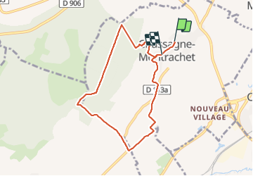
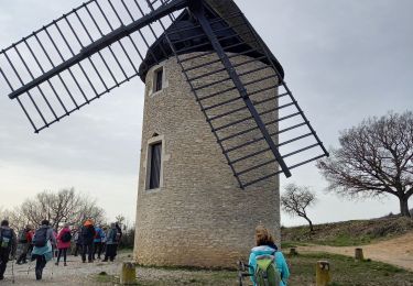
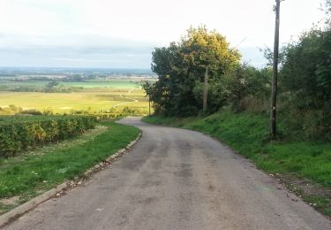
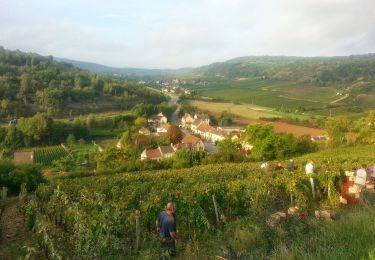
Randonnée Marche de 7,6 km à découvrir à Bourgogne-Franche-Comté, Côte-d'Or, Chassagne-Montrachet. Cette randonnée est proposée par Béatrice Micots.
Description
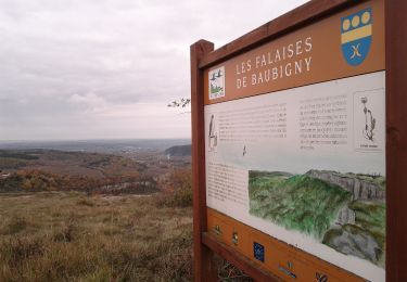
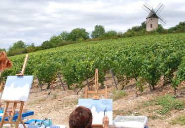
jolis paysages, en plat, puis en montée sous bois, de nouveau plat et descente, traversée du parc municipal.
Localisation
Pays :
France
Région :
Bourgogne-Franche-Comté
Département/Province :
Côte-d'Or
Commune :
Chassagne-Montrachet
Localité :
Unknown
Départ:(Dec)
Départ:(UTM)
631615 ; 5199704 (31T) N.
Commentaires
Randonnées à proximité
![Randonnée Marche Santenay - Santenay Le Moulin de Santenay page 165 - Photo](https://media.geolcdn.com/t/375/260/959aad95-3ace-4b9a-b3e0-f1e7f87da723.jpg&format=jpg&maxdim=2)
![Marche Marche](https://static1.geolcdn.com/sitytour/trail-icons/101.png)
Santenay Le Moulin de Santenay page 165
Marche
Difficile
(1)
Santenay,
Bourgogne-Franche-Comté,
Côte-d'Or,
France
![](/images/other/stat-length.png)
12 km | 16,7 km-effort
3h 48min
![](https://static1.geolcdn.com/siteimages/upload/files/16400158638029165_repeat_loop_refresh_sync_direction_icon.png)
Oui
![Randonnée Marche La Rochepot - DYN - la-rochepot-fontaine-dxorches 18km - Photo](https://media.geolcdn.com/t/375/260/ext.jpg?maxdim=2&url=https%3A%2F%2Fstatic1.geolcdn.com%2Fsiteimages%2Fupload%2Ffiles%2F1553511878bg_sport_marche.png)
![Marche Marche](https://static1.geolcdn.com/sitytour/trail-icons/101.png)
DYN - la-rochepot-fontaine-dxorches 18km
Marche
Très difficile
(1)
La Rochepot,
Bourgogne-Franche-Comté,
Côte-d'Or,
France
![](/images/other/stat-length.png)
17,9 km | 26 km-effort
5h 54min
![](https://static1.geolcdn.com/siteimages/upload/files/16400158638029165_repeat_loop_refresh_sync_direction_icon.png)
Oui
![Randonnée A pied Puligny-Montrachet - Ballade en Montrachet - Photo](https://media.geolcdn.com/t/375/260/d9d81137-5e0d-40b6-a13f-62abe2a87764.jpeg&format=jpg&maxdim=2)
![A pied A pied](https://static1.geolcdn.com/sitytour/trail-icons/100.png)
Ballade en Montrachet
A pied
Facile
Puligny-Montrachet,
Bourgogne-Franche-Comté,
Côte-d'Or,
France
![](/images/other/stat-length.png)
8 km | 10,2 km-effort
2h 19min
![](https://static1.geolcdn.com/siteimages/upload/files/16400158638029165_repeat_loop_refresh_sync_direction_icon.png)
Oui
![Randonnée A pied Meursault - Sentier Meursault-Blagny - Photo](https://media.geolcdn.com/t/375/260/bec2b132-1a40-4bb2-b8bd-39c61294cd06.jpeg&format=jpg&maxdim=2)
![A pied A pied](https://static1.geolcdn.com/sitytour/trail-icons/100.png)
Sentier Meursault-Blagny
A pied
Facile
Meursault,
Bourgogne-Franche-Comté,
Côte-d'Or,
France
![](/images/other/stat-length.png)
7,4 km | 9,8 km-effort
2h 13min
![](https://static1.geolcdn.com/siteimages/upload/files/16400158638029165_repeat_loop_refresh_sync_direction_icon.png)
Oui
![Randonnée A pied La Rochepot - Sentier des Roches - Photo](https://media.geolcdn.com/t/375/260/b77770c8-6448-484a-9e88-f705666674c5.jpeg&format=jpg&maxdim=2)
![A pied A pied](https://static1.geolcdn.com/sitytour/trail-icons/100.png)
Sentier des Roches
A pied
Moyen
La Rochepot,
Bourgogne-Franche-Comté,
Côte-d'Or,
France
![](/images/other/stat-length.png)
14,1 km | 21 km-effort
4h 46min
![](https://static1.geolcdn.com/siteimages/upload/files/16400158638029165_repeat_loop_refresh_sync_direction_icon.png)
Oui
![Randonnée A pied Santenay - Circuit des Crêtes - Photo](https://media.geolcdn.com/t/375/260/547b2add-c27d-4fd8-89ec-29b77b06fbc9.jpeg&format=jpg&maxdim=2)
![A pied A pied](https://static1.geolcdn.com/sitytour/trail-icons/100.png)
Circuit des Crêtes
A pied
Facile
Santenay,
Bourgogne-Franche-Comté,
Côte-d'Or,
France
![](/images/other/stat-length.png)
11 km | 16,2 km-effort
3h 40min
![](https://static1.geolcdn.com/siteimages/upload/files/16400158638029165_repeat_loop_refresh_sync_direction_icon.png)
Oui
![Randonnée Marche Remigny - Remigny la vallée de la Dheune page 19 - Photo](https://media.geolcdn.com/t/375/260/ext.jpg?maxdim=2&url=https%3A%2F%2Fstatic1.geolcdn.com%2Fsiteimages%2Fupload%2Ffiles%2F1553511878bg_sport_marche.png)
![Marche Marche](https://static1.geolcdn.com/sitytour/trail-icons/101.png)
Remigny la vallée de la Dheune page 19
Marche
Facile
(5)
Remigny,
Bourgogne-Franche-Comté,
Saône-et-Loire,
France
![](/images/other/stat-length.png)
13,2 km | 17,9 km-effort
2h 55min
![](https://static1.geolcdn.com/siteimages/upload/files/16400158638029165_repeat_loop_refresh_sync_direction_icon.png)
Oui
![Randonnée V.T.T. Chagny - chamilly - Photo](https://media.geolcdn.com/t/375/260/ext.jpg?maxdim=2&url=https%3A%2F%2Fstatic1.geolcdn.com%2Fsiteimages%2Fupload%2Ffiles%2F1524743154velo.jpg)
![V.T.T. V.T.T.](https://static1.geolcdn.com/sitytour/trail-icons/202.png)
chamilly
V.T.T.
Moyen
(1)
Chagny,
Bourgogne-Franche-Comté,
Saône-et-Loire,
France
![](/images/other/stat-length.png)
22 km | 28 km-effort
2h 16min
![](https://static1.geolcdn.com/siteimages/upload/files/16400158638029165_repeat_loop_refresh_sync_direction_icon.png)
Non
![Randonnée Marche Saint-Aubin - Saint-Aubin - Photo](https://media.geolcdn.com/t/375/260/9e5d7bbf-2d81-4476-8d42-f6f7f9bffb57.jpg&format=jpg&maxdim=2)
![Marche Marche](https://static1.geolcdn.com/sitytour/trail-icons/101.png)
Saint-Aubin
Marche
Moyen
Saint-Aubin,
Bourgogne-Franche-Comté,
Côte-d'Or,
France
![](/images/other/stat-length.png)
21 km | 29 km-effort
4h 53min
![](https://static1.geolcdn.com/siteimages/upload/files/16400158638029165_repeat_loop_refresh_sync_direction_icon.png)
Oui