![](/images/other/stat-length.png)
![Randonnée Marche Carthagène - El Portus Est Muella Ramirez - Photo](https://media.geolcdn.com/t/1900/400/ext.pjpeg?maxdim=2&url=https%3A%2F%2Fmedia.geolcdn.com%2Ff%2F38d43867-d960-4a6d-a3e9-91e7815918e8.jpg)
El Portus Est Muella Ramirez
jll7513
Utilisateur
![Longueur](/images/other/stat-length.png)
Longueur
8,5 km
![Altitude max](https://static1.geolcdn.com/siteimages/upload/files/1508320355ic_sort_altitude_max_24dp.png)
Altitude max
336 m
![Dénivelé positif](https://static1.geolcdn.com/siteimages/upload/files/1508320355ic_sort_den_pos_24dp.png)
Dénivelé positif
346 m
![Km-Effort](/images/other/stat-length.png)
Km-Effort
13,1 km
![Altitude min](https://static1.geolcdn.com/siteimages/upload/files/1508320355ic_sort_altitude_min_24dp.png)
Altitude min
2 m
![Dénivelé négatif](https://static1.geolcdn.com/siteimages/upload/files/1508320355ic_sort_den_neg_24dp.png)
Dénivelé négatif
347 m
![Boucle](https://static1.geolcdn.com/siteimages/upload/files/16400158638029165_repeat_loop_refresh_sync_direction_icon.png)
Boucle
Oui
Date de création :
2021-09-24 06:09:04.0
Dernière modification :
2021-09-28 13:50:53.46
![Marche](https://static1.geolcdn.com/sitytour/trail-icons/101.png)
2h01
Difficulté : Moyen
![Scannez ce code QR pour ouvrir la randonnée dans l'application SityTrail](https://capi.geolives.com/qq0zvz2zws4bq2lad0pu/sitytour/trails/2947674/qr.png?size=200)
Application GPS de randonnée GRATUITE
À propos
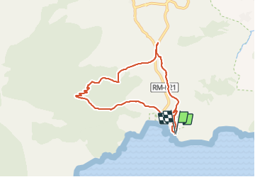
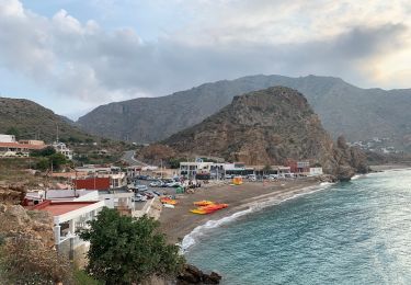
Randonnée Marche de 8,5 km à découvrir à Région de Murcie, Région de Murcie, Carthagène. Cette randonnée est proposée par jll7513.
Description
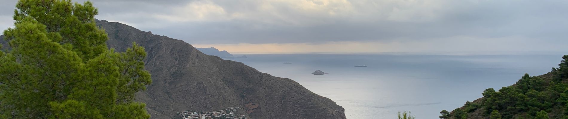
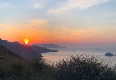
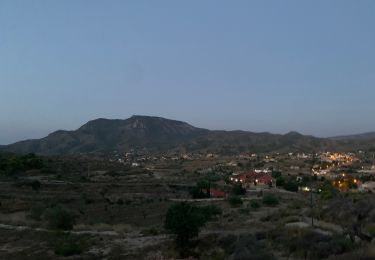
Départ de cette petite randonnée faite depuis le camping naturiste EL PORTUS. Mais peut-être faites en partant de la route. Chemin en face de la sortie du camping. Beau point de vue sur la base de EL PORTUS, le camping et le village.
Localisation
Pays :
Espagne
Région :
Région de Murcie
Département/Province :
Région de Murcie
Commune :
Carthagène
Localité :
Diputación de Canteras
Départ:(Dec)
Départ:(UTM)
670607 ; 4161206 (30S) N.
Commentaires
Randonnées à proximité
![Randonnée Marche Carthagène - El Portus camping Punta Del Moco retour rambla - Photo](https://media.geolcdn.com/t/375/260/ext.jpg?maxdim=2&url=https%3A%2F%2Fmedia.geolcdn.com%2Ff%2F62801927-e629-43de-b44e-e61405eeb0bb.jpg)
![Marche Marche](https://static1.geolcdn.com/sitytour/trail-icons/101.png)
El Portus camping Punta Del Moco retour rambla
Marche
Difficile
Carthagène,
Région de Murcie,
Région de Murcie,
Espagne
![](/images/other/stat-length.png)
5,7 km | 10,6 km-effort
2h 25min
![](https://static1.geolcdn.com/siteimages/upload/files/16400158638029165_repeat_loop_refresh_sync_direction_icon.png)
Oui
![Randonnée Marche Carthagène - El Portus Galifa contour Morre Del Pino retour par Ramblas - Photo](https://media.geolcdn.com/t/375/260/ext.jpg?maxdim=2&url=https%3A%2F%2Fmedia.geolcdn.com%2Ff%2Ffb7ad619-7f1d-493d-b7fb-18811e1e1d2f.jpg)
![Marche Marche](https://static1.geolcdn.com/sitytour/trail-icons/101.png)
El Portus Galifa contour Morre Del Pino retour par Ramblas
Marche
Facile
Carthagène,
Région de Murcie,
Région de Murcie,
Espagne
![](/images/other/stat-length.png)
11,6 km | 14,8 km-effort
2h 9min
![](https://static1.geolcdn.com/siteimages/upload/files/16400158638029165_repeat_loop_refresh_sync_direction_icon.png)
Oui
![Randonnée Marche Carthagène - El Portus La Muella montée par le coté Nord descente par le coté Est - Photo](https://media.geolcdn.com/t/375/260/ext.jpg?maxdim=2&url=https%3A%2F%2Fmedia.geolcdn.com%2Ff%2Fb1c66ebf-2b6a-432b-9142-b41195e929d1.JPG)
![Marche Marche](https://static1.geolcdn.com/sitytour/trail-icons/101.png)
El Portus La Muella montée par le coté Nord descente par le coté Est
Marche
Moyen
Carthagène,
Région de Murcie,
Région de Murcie,
Espagne
![](/images/other/stat-length.png)
8 km | 14,2 km-effort
2h 17min
![](https://static1.geolcdn.com/siteimages/upload/files/16400158638029165_repeat_loop_refresh_sync_direction_icon.png)
Oui
![Randonnée Marche Carthagène - El Portus camping à village retour par plage et rambla - Photo](https://media.geolcdn.com/t/375/260/ext.jpg?maxdim=2&url=https%3A%2F%2Fmedia.geolcdn.com%2Ff%2Fce6c2749-a821-4b1d-9e05-c5edc1c688cc.jpg)
![Marche Marche](https://static1.geolcdn.com/sitytour/trail-icons/101.png)
El Portus camping à village retour par plage et rambla
Marche
Facile
Carthagène,
Région de Murcie,
Région de Murcie,
Espagne
![](/images/other/stat-length.png)
3 km | 3,8 km-effort
44min
![](https://static1.geolcdn.com/siteimages/upload/files/16400158638029165_repeat_loop_refresh_sync_direction_icon.png)
Oui
![Randonnée Marche Carthagène - El Portus Puntal del Moco Ramirez retour Camping - Photo](https://media.geolcdn.com/t/375/260/ext.jpg?maxdim=2&url=https%3A%2F%2Fstatic1.geolcdn.com%2Fsiteimages%2Fupload%2Ffiles%2F1553511878bg_sport_marche.png)
![Marche Marche](https://static1.geolcdn.com/sitytour/trail-icons/101.png)
El Portus Puntal del Moco Ramirez retour Camping
Marche
Difficile
Carthagène,
Région de Murcie,
Région de Murcie,
Espagne
![](/images/other/stat-length.png)
5,3 km | 10,2 km-effort
2h 30min
![](https://static1.geolcdn.com/siteimages/upload/files/16400158638029165_repeat_loop_refresh_sync_direction_icon.png)
Oui
![Randonnée Marche Carthagène - Espagne. El Portus La Muela Cabezo Colorado Casa Comandante retour bord de mer - Photo](https://media.geolcdn.com/t/375/260/ext.jpg?maxdim=2&url=https%3A%2F%2Fstatic1.geolcdn.com%2Fsiteimages%2Fupload%2Ffiles%2F1553511878bg_sport_marche.png)
![Marche Marche](https://static1.geolcdn.com/sitytour/trail-icons/101.png)
Espagne. El Portus La Muela Cabezo Colorado Casa Comandante retour bord de mer
Marche
Difficile
(1)
Carthagène,
Région de Murcie,
Région de Murcie,
Espagne
![](/images/other/stat-length.png)
8,4 km | 15,6 km-effort
3h 17min
![](https://static1.geolcdn.com/siteimages/upload/files/16400158638029165_repeat_loop_refresh_sync_direction_icon.png)
Non
![Randonnée Marche Carthagène - Espagne. El Portus boucle en passant par La Muella - Photo](https://media.geolcdn.com/t/375/260/ext.jpg?maxdim=2&url=https%3A%2F%2Fstatic1.geolcdn.com%2Fsiteimages%2Fupload%2Ffiles%2F1553511878bg_sport_marche.png)
![Marche Marche](https://static1.geolcdn.com/sitytour/trail-icons/101.png)
Espagne. El Portus boucle en passant par La Muella
Marche
Moyen
Carthagène,
Région de Murcie,
Région de Murcie,
Espagne
![](/images/other/stat-length.png)
11,2 km | 18,1 km-effort
3h 7min
![](https://static1.geolcdn.com/siteimages/upload/files/16400158638029165_repeat_loop_refresh_sync_direction_icon.png)
Non
![Randonnée Marche Carthagène - w-spanje-rondje-la-muela - Photo](https://media.geolcdn.com/t/375/260/ext.jpg?maxdim=2&url=https%3A%2F%2Fstatic1.geolcdn.com%2Fsiteimages%2Fupload%2Ffiles%2F1553511878bg_sport_marche.png)
![Marche Marche](https://static1.geolcdn.com/sitytour/trail-icons/101.png)
w-spanje-rondje-la-muela
Marche
Très facile
Carthagène,
Région de Murcie,
Région de Murcie,
Espagne
![](/images/other/stat-length.png)
7,7 km | 13,9 km-effort
Inconnu
![](https://static1.geolcdn.com/siteimages/upload/files/16400158638029165_repeat_loop_refresh_sync_direction_icon.png)
Oui
![Randonnée Course à pied Carthagène - El Portus jogging de camping à Galifa retour par ramblas - Photo](https://media.geolcdn.com/t/375/260/ext.jpg?maxdim=2&url=https%3A%2F%2Fstatic1.geolcdn.com%2Fsiteimages%2Fupload%2Ffiles%2F1524743154running.jpg)
![Course à pied Course à pied](https://static1.geolcdn.com/sitytour/trail-icons/103.png)
El Portus jogging de camping à Galifa retour par ramblas
Course à pied
Facile
Carthagène,
Région de Murcie,
Région de Murcie,
Espagne
![](/images/other/stat-length.png)
7,5 km | 9,2 km-effort
57min
![](https://static1.geolcdn.com/siteimages/upload/files/16400158638029165_repeat_loop_refresh_sync_direction_icon.png)
Oui