![](/images/other/stat-length.png)
![Randonnée Marche Uvernet-Fours - Ventebrun depuis Pont de Julien - Photo](https://media.geolcdn.com/t/1900/400/851cfbca-49f7-4dce-84ca-2e56fcb5741d.jpg&format=pjpeg&maxdim=2)
Ventebrun depuis Pont de Julien
Uio73
Utilisateur
![Longueur](/images/other/stat-length.png)
![Altitude max](https://static1.geolcdn.com/siteimages/upload/files/1508320355ic_sort_altitude_max_24dp.png)
![Dénivelé positif](https://static1.geolcdn.com/siteimages/upload/files/1508320355ic_sort_den_pos_24dp.png)
![Km-Effort](/images/other/stat-length.png)
![Altitude min](https://static1.geolcdn.com/siteimages/upload/files/1508320355ic_sort_altitude_min_24dp.png)
![Dénivelé négatif](https://static1.geolcdn.com/siteimages/upload/files/1508320355ic_sort_den_neg_24dp.png)
![Boucle](https://static1.geolcdn.com/siteimages/upload/files/16400158638029165_repeat_loop_refresh_sync_direction_icon.png)
![Marche](https://static1.geolcdn.com/sitytour/trail-icons/101.png)
6h09
Difficulté : Difficile
![Scannez ce code QR pour ouvrir la randonnée dans l'application SityTrail](https://capi.geolives.com/qq0zvz2zws4bq2lad0pu/sitytour/trails/2936586/qr.png?size=200)
Application GPS de randonnée GRATUITE
À propos
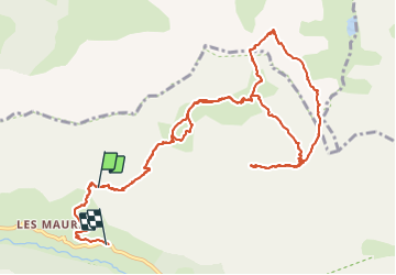
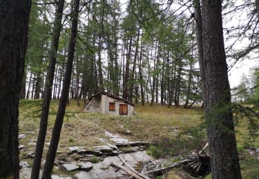
Randonnée Marche de 15 km à découvrir à Provence-Alpes-Côte d'Azur, Alpes-de-Haute-Provence, Uvernet-Fours. Cette randonnée est proposée par Uio73.
Description
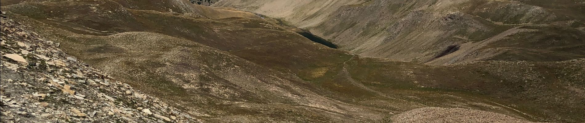
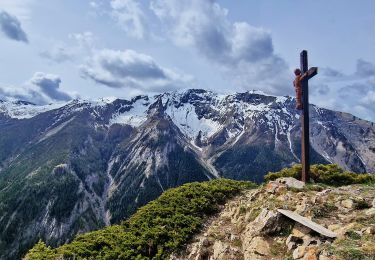
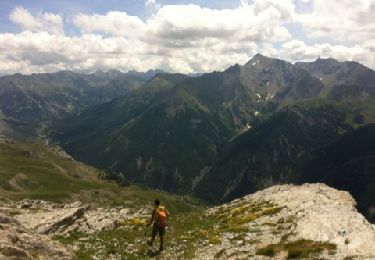
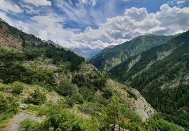
Très belle randonnée dans un vallon sauvage avec plein de bouquetins. Attention le dénivelé de montée est identique à celui de la descente (j'ai lancé l'enregistrement un peu tard). Le chemin n'apparait pas sur la carte IGN, mais il est très bien tracé en réalité jusqu'au sommet. L'itinéraire jusqu'au sommet en aller-retour par le sentier est facile.
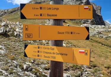
On a rajouté une boucle en faisant le tour du "Rocher de Tête Clapouse" avec un passage à travers la falaise de la "Barre de Terres Plaines" dans un pierrier raide (d'où la classification difficile).
Localisation
Commentaires
Randonnées à proximité
![Randonnée Marche Uvernet-Fours - UVERNET. Bayasse, tour de la pierre éclatée o - Photo](https://media.geolcdn.com/t/375/260/585a8992-95bd-4974-8e25-bbc57e644b01.jpg&format=jpg&maxdim=2)
![Marche Marche](https://static1.geolcdn.com/sitytour/trail-icons/101.png)
Marche
![](/images/other/stat-length.png)
![](https://static1.geolcdn.com/siteimages/upload/files/16400158638029165_repeat_loop_refresh_sync_direction_icon.png)
![Randonnée Marche Uvernet-Fours - Col de la Cloche - Croix de Saint Médard Via Villard d'Abas - Photo](https://media.geolcdn.com/t/375/260/308bf2a1-9335-4e20-b2f5-d29a649f0d5e.jpg&format=jpg&maxdim=2)
![Marche Marche](https://static1.geolcdn.com/sitytour/trail-icons/101.png)
Marche
![](/images/other/stat-length.png)
![](https://static1.geolcdn.com/siteimages/upload/files/16400158638029165_repeat_loop_refresh_sync_direction_icon.png)
![Randonnée Marche Enchastrayes - chapeau de gendarme. Ubaye - Photo](https://media.geolcdn.com/t/375/260/ext.jpg?maxdim=2&url=https%3A%2F%2Fservices.sitytrail.com%2FGeolivesWS%2FDownloadMedia.ashx%3FTrailID%3D213716%26Media%3D20130816125107.jpg)
![Marche Marche](https://static1.geolcdn.com/sitytour/trail-icons/101.png)
Marche
![](/images/other/stat-length.png)
![](https://static1.geolcdn.com/siteimages/upload/files/16400158638029165_repeat_loop_refresh_sync_direction_icon.png)
![Randonnée Marche Uvernet-Fours - Autour de la Pierre Eclatée - Photo](https://media.geolcdn.com/t/375/260/ext.jpg?maxdim=2&url=https%3A%2F%2Fservices.sitytrail.com%2FGeolivesWS%2FDownloadMedia.ashx%3FTrailID%3D101188%26Media%3D675_1.jpg)
![Marche Marche](https://static1.geolcdn.com/sitytour/trail-icons/101.png)
Marche
![](/images/other/stat-length.png)
![](https://static1.geolcdn.com/siteimages/upload/files/16400158638029165_repeat_loop_refresh_sync_direction_icon.png)
![Randonnée Marche Enchastrayes - chapeau de gendarme - Photo](https://media.geolcdn.com/t/375/260/33ebb070-0a87-4026-a47d-467969733ca3.jpg&format=jpg&maxdim=2)
![Marche Marche](https://static1.geolcdn.com/sitytour/trail-icons/101.png)
Marche
![](/images/other/stat-length.png)
![](https://static1.geolcdn.com/siteimages/upload/files/16400158638029165_repeat_loop_refresh_sync_direction_icon.png)
![Randonnée Marche Enchastrayes - col du Chapeau de gendarme et de Gyp Aller via flanc est Retour via flanc nord - Photo](https://media.geolcdn.com/t/375/260/eac4dd18-0f0f-4143-9343-f0bf7d4ed81b.jpg&format=jpg&maxdim=2)
![Marche Marche](https://static1.geolcdn.com/sitytour/trail-icons/101.png)
Marche
![](/images/other/stat-length.png)
![](https://static1.geolcdn.com/siteimages/upload/files/16400158638029165_repeat_loop_refresh_sync_direction_icon.png)
![Marche Marche](https://static1.geolcdn.com/sitytour/trail-icons/101.png)
Marche
![](/images/other/stat-length.png)
![](https://static1.geolcdn.com/siteimages/upload/files/16400158638029165_repeat_loop_refresh_sync_direction_icon.png)
![Randonnée Marche Uvernet-Fours - rando col de la cloche 8/07/2021 - Photo](https://media.geolcdn.com/t/375/260/95736b36-304b-4736-8102-5e823bc5f215.jpg&format=jpg&maxdim=2)
![Marche Marche](https://static1.geolcdn.com/sitytour/trail-icons/101.png)
Marche
![](/images/other/stat-length.png)
![](https://static1.geolcdn.com/siteimages/upload/files/16400158638029165_repeat_loop_refresh_sync_direction_icon.png)
![Randonnée Marche Uvernet-Fours - Cabane de la petite Saume. 27/09/20 - Photo](https://media.geolcdn.com/t/375/260/40416cf0-e9b3-42ff-ad12-bc7e310f746b.jpg&format=jpg&maxdim=2)
![Marche Marche](https://static1.geolcdn.com/sitytour/trail-icons/101.png)
Marche
![](/images/other/stat-length.png)
![](https://static1.geolcdn.com/siteimages/upload/files/16400158638029165_repeat_loop_refresh_sync_direction_icon.png)
Merci pour ce partage !