![](/images/other/stat-length.png)
![Randonnée Marche Fontenu - GR_559_AC_03_Fontenu_Bonlieu_20210914 - Photo](https://media.geolcdn.com/t/1900/400/626a9953-b37f-463e-a917-966facbebecd.jpg&format=pjpeg&maxdim=2)
GR_559_AC_03_Fontenu_Bonlieu_20210914
patrickdanilo
Utilisateur
![Longueur](/images/other/stat-length.png)
Longueur
15,4 km
![Altitude max](https://static1.geolcdn.com/siteimages/upload/files/1508320355ic_sort_altitude_max_24dp.png)
Altitude max
822 m
![Dénivelé positif](https://static1.geolcdn.com/siteimages/upload/files/1508320355ic_sort_den_pos_24dp.png)
Dénivelé positif
512 m
![Km-Effort](/images/other/stat-length.png)
Km-Effort
22 km
![Altitude min](https://static1.geolcdn.com/siteimages/upload/files/1508320355ic_sort_altitude_min_24dp.png)
Altitude min
530 m
![Dénivelé négatif](https://static1.geolcdn.com/siteimages/upload/files/1508320355ic_sort_den_neg_24dp.png)
Dénivelé négatif
321 m
![Boucle](https://static1.geolcdn.com/siteimages/upload/files/16400158638029165_repeat_loop_refresh_sync_direction_icon.png)
Boucle
Non
Date de création :
2021-09-14 07:29:21.388
Dernière modification :
2022-02-09 10:47:16.373
![Marche](https://static1.geolcdn.com/sitytour/trail-icons/101.png)
4h51
Difficulté : Difficile
![Scannez ce code QR pour ouvrir la randonnée dans l'application SityTrail](https://capi.geolives.com/qq0zvz2zws4bq2lad0pu/sitytour/trails/2936317/qr.png?size=200)
Application GPS de randonnée GRATUITE
À propos
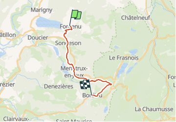
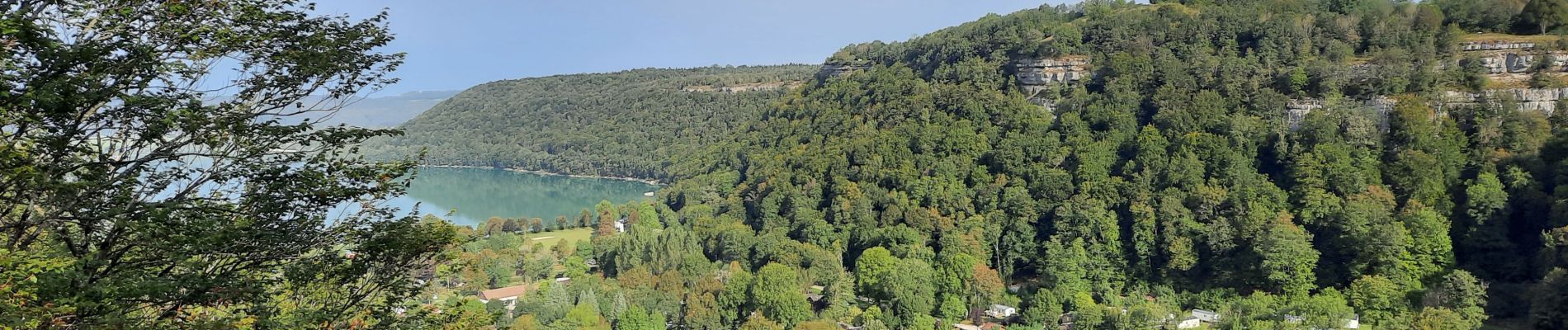
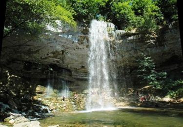
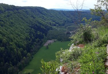
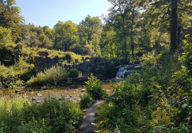
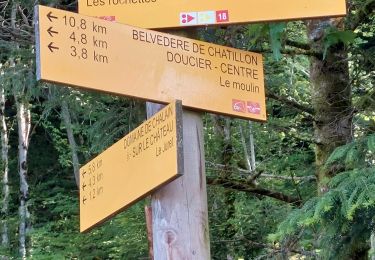
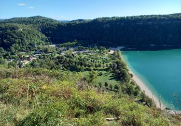
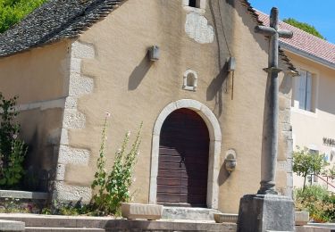
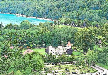
Randonnée Marche de 15,4 km à découvrir à Bourgogne-Franche-Comté, Jura, Fontenu. Cette randonnée est proposée par patrickdanilo.
Description
GR®559
Le Jura d'Ouest en Est
de Montaigu (Jura) Bourgogne-Franche-Comté
aux Rousses (Jura) Bourgogne-Franche-Comté
82,8km
Localisation
Pays :
France
Région :
Bourgogne-Franche-Comté
Département/Province :
Jura
Commune :
Fontenu
Localité :
Unknown
Départ:(Dec)
Départ:(UTM)
715927 ; 5172119 (31T) N.
Commentaires
Randonnées à proximité
![Randonnée Marche Menétrux-en-Joux - Les cascades du Hérisson : Boucle du randonneur - Photo](https://media.geolcdn.com/t/375/260/ext.jpg?maxdim=2&url=https%3A%2F%2Fservices.sitytrail.com%2FGeolivesWS%2FDownloadMedia.ashx%3FTrailID%3D792637%26Media%3Dfix__20170718143932.jpg)
![Marche Marche](https://static1.geolcdn.com/sitytour/trail-icons/101.png)
Les cascades du Hérisson : Boucle du randonneur
Marche
Moyen
(3)
Menétrux-en-Joux,
Bourgogne-Franche-Comté,
Jura,
France
![](/images/other/stat-length.png)
14,5 km | 20 km-effort
5h 10min
![](https://static1.geolcdn.com/siteimages/upload/files/16400158638029165_repeat_loop_refresh_sync_direction_icon.png)
Oui
![Randonnée Marche Menétrux-en-Joux - Le Hérisson et ses cascades - Photo](https://media.geolcdn.com/t/375/260/ext.jpg?maxdim=2&url=https%3A%2F%2Fservices.sitytrail.com%2FGeolivesWS%2FDownloadMedia.ashx%3FTrailID%3D109457%26Media%3D3924_2.jpg)
![Marche Marche](https://static1.geolcdn.com/sitytour/trail-icons/101.png)
Le Hérisson et ses cascades
Marche
Moyen
(7)
Menétrux-en-Joux,
Bourgogne-Franche-Comté,
Jura,
France
![](/images/other/stat-length.png)
11,9 km | 17,6 km-effort
4h 0min
![](https://static1.geolcdn.com/siteimages/upload/files/16400158638029165_repeat_loop_refresh_sync_direction_icon.png)
Oui
![Randonnée V.T.T. Doucier - La Dame Blanche - Doucier - Photo](https://media.geolcdn.com/t/375/260/ext.jpg?maxdim=2&url=https%3A%2F%2Fservices.sitytrail.com%2FGeolivesWS%2FDownloadMedia.ashx%3FTrailID%3D104084%26Media%3D7109_1.jpg)
![V.T.T. V.T.T.](https://static1.geolcdn.com/sitytour/trail-icons/202.png)
La Dame Blanche - Doucier
V.T.T.
Difficile
(1)
Doucier,
Bourgogne-Franche-Comté,
Jura,
France
![](/images/other/stat-length.png)
33 km | 42 km-effort
2h 30min
![](https://static1.geolcdn.com/siteimages/upload/files/16400158638029165_repeat_loop_refresh_sync_direction_icon.png)
Oui
![Randonnée Marche Menétrux-en-Joux - Menetrux. Les Cascades du hérisson. - Photo](https://media.geolcdn.com/t/375/260/8e5e2f86-bd6e-477f-a743-cdfd861bfcc6.jpg&format=jpg&maxdim=2)
![Marche Marche](https://static1.geolcdn.com/sitytour/trail-icons/101.png)
Menetrux. Les Cascades du hérisson.
Marche
Moyen
Menétrux-en-Joux,
Bourgogne-Franche-Comté,
Jura,
France
![](/images/other/stat-length.png)
13,9 km | 20 km-effort
3h 59min
![](https://static1.geolcdn.com/siteimages/upload/files/16400158638029165_repeat_loop_refresh_sync_direction_icon.png)
Oui
![Randonnée Marche Menétrux-en-Joux - Ménétrux-en-Joux - cascades Evantail et Hérisson - Saut de la Forge - La Fromagerie - Photo](https://media.geolcdn.com/t/375/260/d48ed8df-2feb-4b91-8f37-fd07908921c0.jpg&format=jpg&maxdim=2)
![Marche Marche](https://static1.geolcdn.com/sitytour/trail-icons/101.png)
Ménétrux-en-Joux - cascades Evantail et Hérisson - Saut de la Forge - La From...
Marche
Très difficile
Menétrux-en-Joux,
Bourgogne-Franche-Comté,
Jura,
France
![](/images/other/stat-length.png)
13,6 km | 19,7 km-effort
4h 28min
![](https://static1.geolcdn.com/siteimages/upload/files/16400158638029165_repeat_loop_refresh_sync_direction_icon.png)
Oui
![Randonnée Marche Doucier - Balisage Lac de Chambly - Photo](https://media.geolcdn.com/t/375/260/a66299b1-acba-4c28-b135-ec0a9e2beef8.jpg&format=jpg&maxdim=2)
![Marche Marche](https://static1.geolcdn.com/sitytour/trail-icons/101.png)
Balisage Lac de Chambly
Marche
Difficile
(1)
Doucier,
Bourgogne-Franche-Comté,
Jura,
France
![](/images/other/stat-length.png)
11,4 km | 14,6 km-effort
3h 19min
![](https://static1.geolcdn.com/siteimages/upload/files/16400158638029165_repeat_loop_refresh_sync_direction_icon.png)
Oui
![Randonnée Marche Fontenu - Tour du lac de Chalain - Photo](https://media.geolcdn.com/t/375/260/1c5595f4-5d36-4f85-b728-7ff9b046c0c9.jpg&format=jpg&maxdim=2)
![Marche Marche](https://static1.geolcdn.com/sitytour/trail-icons/101.png)
Tour du lac de Chalain
Marche
Moyen
Fontenu,
Bourgogne-Franche-Comté,
Jura,
France
![](/images/other/stat-length.png)
12,7 km | 16,3 km-effort
3h 56min
![](https://static1.geolcdn.com/siteimages/upload/files/16400158638029165_repeat_loop_refresh_sync_direction_icon.png)
Oui
![Randonnée Marche Menétrux-en-Joux - CASCADES DU HERISSON DEPUIS MENETRUX-EN-JOUX - Photo](https://media.geolcdn.com/t/375/260/e70f75bd-2d3f-4c85-950b-39b567cdc95a.jpg&format=jpg&maxdim=2)
![Marche Marche](https://static1.geolcdn.com/sitytour/trail-icons/101.png)
CASCADES DU HERISSON DEPUIS MENETRUX-EN-JOUX
Marche
Très difficile
Menétrux-en-Joux,
Bourgogne-Franche-Comté,
Jura,
France
![](/images/other/stat-length.png)
15 km | 21 km-effort
4h 0min
![](https://static1.geolcdn.com/siteimages/upload/files/16400158638029165_repeat_loop_refresh_sync_direction_icon.png)
Oui
![Randonnée A pied Marigny - La Queille - Photo](https://media.geolcdn.com/t/375/260/2900c982-6017-4412-a9fc-672092055637.jpeg&format=jpg&maxdim=2)
![A pied A pied](https://static1.geolcdn.com/sitytour/trail-icons/100.png)
La Queille
A pied
Facile
Marigny,
Bourgogne-Franche-Comté,
Jura,
France
![](/images/other/stat-length.png)
6,7 km | 8,6 km-effort
1h 57min
![](https://static1.geolcdn.com/siteimages/upload/files/16400158638029165_repeat_loop_refresh_sync_direction_icon.png)
Non