![](/images/other/stat-length.png)
![Randonnée V.T.T. Interlaken - - Photo](https://media.geolcdn.com/t/1900/400/ext.pjpeg?maxdim=2&url=https%3A%2F%2Fstatic1.geolcdn.com%2Fsiteimages%2Fupload%2Ffiles%2F1524743154velo.jpg)
maturin
Utilisateur
![Longueur](/images/other/stat-length.png)
Longueur
65 km
![Altitude max](https://static1.geolcdn.com/siteimages/upload/files/1508320355ic_sort_altitude_max_24dp.png)
Altitude max
2064 m
![Dénivelé positif](https://static1.geolcdn.com/siteimages/upload/files/1508320355ic_sort_den_pos_24dp.png)
Dénivelé positif
2744 m
![Km-Effort](/images/other/stat-length.png)
Km-Effort
102 km
![Altitude min](https://static1.geolcdn.com/siteimages/upload/files/1508320355ic_sort_altitude_min_24dp.png)
Altitude min
565 m
![Dénivelé négatif](https://static1.geolcdn.com/siteimages/upload/files/1508320355ic_sort_den_neg_24dp.png)
Dénivelé négatif
2716 m
![Boucle](https://static1.geolcdn.com/siteimages/upload/files/16400158638029165_repeat_loop_refresh_sync_direction_icon.png)
Boucle
Non
Date de création :
2014-12-11 00:00:00.0
Dernière modification :
2014-12-11 00:00:00.0
![V.T.T.](https://static1.geolcdn.com/sitytour/trail-icons/202.png)
16h22
Difficulté : Inconnu
![Scannez ce code QR pour ouvrir la randonnée dans l'application SityTrail](https://capi.geolives.com/qq0zvz2zws4bq2lad0pu/sitytour/trails/29323/qr.png?size=200)
Application GPS de randonnée GRATUITE
À propos
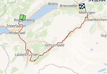
Randonnée V.T.T. de 65 km à découvrir à Berne, Arrondissement administratif d'Interlaken-Oberhasli, Interlaken. Cette randonnée est proposée par maturin.
Description
Retour depuis Meiringen vers interlaken, en train...sinon, en vélo, mais environ 30 km
Localisation
Pays :
Suisse
Région :
Berne
Département/Province :
Arrondissement administratif d'Interlaken-Oberhasli
Commune :
Interlaken
Localité :
Unknown
Départ:(Dec)
Départ:(UTM)
413607 ; 5171410 (32T) N.
Commentaires
Randonnées à proximité
![Randonnée A pied Habkern - Habkern - Bärenei - Photo](https://media.geolcdn.com/t/375/260/5bf8858d-0d92-4513-be83-10494bede7fc.jpeg&format=jpg&maxdim=2)
![A pied A pied](https://static1.geolcdn.com/sitytour/trail-icons/100.png)
Habkern - Bärenei
A pied
Facile
Habkern,
Berne,
Arrondissement administratif d'Interlaken-Oberhasli,
Suisse
![](/images/other/stat-length.png)
3,6 km | 9,6 km-effort
2h 11min
![](https://static1.geolcdn.com/siteimages/upload/files/16400158638029165_repeat_loop_refresh_sync_direction_icon.png)
Non
![Randonnée Marche Unterseen - Randonnée au dessus de Harder Kulm - Photo](https://media.geolcdn.com/t/375/260/892c2f01-47c6-4d5f-b278-0c8915435efa.jpg&format=jpg&maxdim=2)
![Marche Marche](https://static1.geolcdn.com/sitytour/trail-icons/101.png)
Randonnée au dessus de Harder Kulm
Marche
Difficile
Unterseen,
Berne,
Arrondissement administratif d'Interlaken-Oberhasli,
Suisse
![](/images/other/stat-length.png)
6,4 km | 11,4 km-effort
2h 42min
![](https://static1.geolcdn.com/siteimages/upload/files/16400158638029165_repeat_loop_refresh_sync_direction_icon.png)
Non
![Randonnée Marche Gündlischwand - Schynige Platte chemin panoramique 06.07.15 - Photo](https://media.geolcdn.com/t/375/260/ext.jpg?maxdim=2&url=https%3A%2F%2Fservices.sitytrail.com%2FGeolivesWS%2FDownloadMedia.ashx%3FTrailID%3D441975%26Media%3Da208e773-71ba-44ed-a8d6-0cbc898752b8.jpg)
![Marche Marche](https://static1.geolcdn.com/sitytour/trail-icons/101.png)
Schynige Platte chemin panoramique 06.07.15
Marche
Moyen
Gündlischwand,
Berne,
Arrondissement administratif d'Interlaken-Oberhasli,
Suisse
![](/images/other/stat-length.png)
7,4 km | 11,7 km-effort
3h 0min
![](https://static1.geolcdn.com/siteimages/upload/files/16400158638029165_repeat_loop_refresh_sync_direction_icon.png)
Oui
![Randonnée Autre activité Unterseen - sf10_e7c - Photo](https://media.geolcdn.com/t/375/260/ext.jpg?maxdim=2&url=https%3A%2F%2Fstatic1.geolcdn.com%2Fsiteimages%2Fupload%2Ffiles%2F1545311037marcheuse_200dpi.jpg)
![Autre activité Autre activité](https://static1.geolcdn.com/sitytour/trail-icons/900.png)
sf10_e7c
Autre activité
Très facile
Unterseen,
Berne,
Arrondissement administratif d'Interlaken-Oberhasli,
Suisse
![](/images/other/stat-length.png)
24 km | 36 km-effort
8h 25min
![](https://static1.geolcdn.com/siteimages/upload/files/16400158638029165_repeat_loop_refresh_sync_direction_icon.png)
Non
![Randonnée Autre activité Habkern - sf10_e7b - Photo](https://media.geolcdn.com/t/375/260/ext.jpg?maxdim=2&url=https%3A%2F%2Fstatic1.geolcdn.com%2Fsiteimages%2Fupload%2Ffiles%2F1545311037marcheuse_200dpi.jpg)
![Autre activité Autre activité](https://static1.geolcdn.com/sitytour/trail-icons/900.png)
sf10_e7b
Autre activité
Très facile
Habkern,
Berne,
Arrondissement administratif d'Interlaken-Oberhasli,
Suisse
![](/images/other/stat-length.png)
23 km | 40 km-effort
8h 48min
![](https://static1.geolcdn.com/siteimages/upload/files/16400158638029165_repeat_loop_refresh_sync_direction_icon.png)
Non
![Randonnée Vélo Interlaken - st_ral_3 - Photo](https://media.geolcdn.com/t/375/260/ext.jpg?maxdim=2&url=https%3A%2F%2Fstatic1.geolcdn.com%2Fsiteimages%2Fupload%2Ffiles%2F1524743154velo.jpg)
![Vélo Vélo](https://static1.geolcdn.com/sitytour/trail-icons/200.png)
st_ral_3
Vélo
Très facile
Interlaken,
Berne,
Arrondissement administratif d'Interlaken-Oberhasli,
Suisse
![](/images/other/stat-length.png)
59 km | 69 km-effort
Inconnu
![](https://static1.geolcdn.com/siteimages/upload/files/16400158638029165_repeat_loop_refresh_sync_direction_icon.png)
Non
![Randonnée Marche Habkern - Hohgant: Schrattenkalk und Meringeberge - Photo](https://media.geolcdn.com/t/375/260/ext.jpg?maxdim=2&url=https%3A%2F%2Fstatic1.geolcdn.com%2Fsiteimages%2Fupload%2Ffiles%2F1553511878bg_sport_marche.png)
![Marche Marche](https://static1.geolcdn.com/sitytour/trail-icons/101.png)
Hohgant: Schrattenkalk und Meringeberge
Marche
Très facile
Habkern,
Berne,
Arrondissement administratif d'Interlaken-Oberhasli,
Suisse
![](/images/other/stat-length.png)
17,3 km | 33 km-effort
Inconnu
![](https://static1.geolcdn.com/siteimages/upload/files/16400158638029165_repeat_loop_refresh_sync_direction_icon.png)
Non
![Randonnée Marche Gündlischwand - Eiger, Mönch und Jungfrau im Blickfeld - Photo](https://media.geolcdn.com/t/375/260/ext.jpg?maxdim=2&url=https%3A%2F%2Fstatic1.geolcdn.com%2Fsiteimages%2Fupload%2Ffiles%2F1553511878bg_sport_marche.png)
![Marche Marche](https://static1.geolcdn.com/sitytour/trail-icons/101.png)
Eiger, Mönch und Jungfrau im Blickfeld
Marche
Très facile
Gündlischwand,
Berne,
Arrondissement administratif d'Interlaken-Oberhasli,
Suisse
![](/images/other/stat-length.png)
15,9 km | 27 km-effort
Inconnu
![](https://static1.geolcdn.com/siteimages/upload/files/16400158638029165_repeat_loop_refresh_sync_direction_icon.png)
Non
![Randonnée V.T.T. Habkern - Bike32898 - Photo](https://media.geolcdn.com/t/375/260/ext.jpg?maxdim=2&url=https%3A%2F%2Fstatic1.geolcdn.com%2Fsiteimages%2Fupload%2Ffiles%2F1524743154velo.jpg)
![V.T.T. V.T.T.](https://static1.geolcdn.com/sitytour/trail-icons/202.png)
Bike32898
V.T.T.
Très facile
Habkern,
Berne,
Arrondissement administratif d'Interlaken-Oberhasli,
Suisse
![](/images/other/stat-length.png)
41 km | 61 km-effort
Inconnu
![](https://static1.geolcdn.com/siteimages/upload/files/16400158638029165_repeat_loop_refresh_sync_direction_icon.png)
Oui