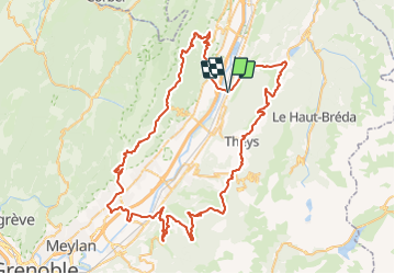
![](/images/other/stat-length.png)
![Randonnée Goncelin - 2021-09-10_18h22m23_Cirkwi-Par_les_balcons_de_Belledonne_et_Chartreuse - Photo](https://media.geolcdn.com/t/1900/400/ext.pjpeg?maxdim=2&url=https%3A%2F%2Fsecurestorage.geolives.com%2Fsitytour%2Ftrail-bg%2Fdefault.jpg)
2021-09-10_18h22m23_Cirkwi-Par_les_balcons_de_Belledonne_et_Chartreuse
Strabon
Utilisateur
![Longueur](/images/other/stat-length.png)
![Altitude max](https://static1.geolcdn.com/siteimages/upload/files/1508320355ic_sort_altitude_max_24dp.png)
![Dénivelé positif](https://static1.geolcdn.com/siteimages/upload/files/1508320355ic_sort_den_pos_24dp.png)
![Km-Effort](/images/other/stat-length.png)
![Altitude min](https://static1.geolcdn.com/siteimages/upload/files/1508320355ic_sort_altitude_min_24dp.png)
![Dénivelé négatif](https://static1.geolcdn.com/siteimages/upload/files/1508320355ic_sort_den_neg_24dp.png)
![Boucle](https://static1.geolcdn.com/siteimages/upload/files/16400158638029165_repeat_loop_refresh_sync_direction_icon.png)
![Scannez ce code QR pour ouvrir la randonnée dans l'application SityTrail](https://capi.geolives.com/qq0zvz2zws4bq2lad0pu/sitytour/trails/2931786/qr.png?size=200)
Application GPS de randonnée GRATUITE
À propos
Randonnée de 95 km à découvrir à Auvergne-Rhône-Alpes, Isère, Goncelin. Cette randonnée est proposée par Strabon.
Description
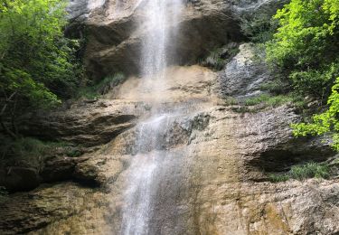
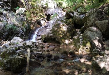
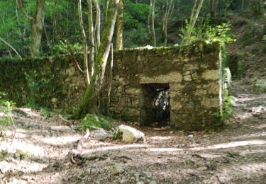
La route tranquille du balcon de Belledonne offre sur toute sa longueur un magnifique panorama sur la vallée du Grésivaudan et la Chartreuse. Un arrêt s’impose au belvédère naturel de la croix du Revollat.Au départ de Goncelin, prendre la D525 jusqu’à Saint-Pierre-d’Allevard, obliquer à droite sur la D280 et mettre le cap sur le col du Barioz, traverser le village de Theys et enchaîner la montée par le col des Ayes au pied de la station des 7 Laux, puis le col des Mouilles. Retour dans la vallée par la D165 jusqu’à Lancey pour retrouver la D523, longer le bord de l’Isère un court instant avant de quitter la D52 et de rejoindre l’autre versant du Grésivaudan à Saint-Nazaire-les-Eymes. À Saint-Nazaire-les-Eymes, traverser la D1090 et prendre la D30 pour accéder au balcon de Chartreuse par Saint-Pancrasse, Saint-Hilaire-du-Touvet et Saint- Bernard-du-Touvet. Attaquer la dernière partie de la randonnée par le col de Marcieu et une agréable descente sur la Flachère par la D282 et par la D19 jusqu’à Saint-Vincent-de-Mercuze, avant d’arriver au Touvet. Rejoindre Goncelin en traversant la D1090 et le pont sur l’Isère.
Localisation
Commentaires
Randonnées à proximité
![Randonnée Marche La Terrasse - Les Cascades du Glesy et le Belvédère du Puy - Photo](https://media.geolcdn.com/t/375/260/ext.jpg?maxdim=2&url=https%3A%2F%2Fservices.sitytrail.com%2FGeolivesWS%2FDownloadMedia.ashx%3FTrailID%3D859792%26Media%3Dfix__20171109135601.jpg)
![Marche Marche](https://static1.geolcdn.com/sitytour/trail-icons/101.png)
Marche
![](/images/other/stat-length.png)
![](https://static1.geolcdn.com/siteimages/upload/files/16400158638029165_repeat_loop_refresh_sync_direction_icon.png)
![Randonnée Marche Saint-Vincent-de-Mercuze - 38 cascades d alloix - Photo](https://media.geolcdn.com/t/375/260/ac959965-e9e6-43ac-868c-d1afc5ef4777.jpg&format=jpg&maxdim=2)
![Marche Marche](https://static1.geolcdn.com/sitytour/trail-icons/101.png)
Marche
![](/images/other/stat-length.png)
![](https://static1.geolcdn.com/siteimages/upload/files/16400158638029165_repeat_loop_refresh_sync_direction_icon.png)
![Randonnée V.T.T. Theys - Autour du crêt de Chazay - Photo](https://media.geolcdn.com/t/375/260/ext.jpg?maxdim=2&url=https%3A%2F%2Fstatic1.geolcdn.com%2Fsiteimages%2Fupload%2Ffiles%2F1524743154velo.jpg)
![V.T.T. V.T.T.](https://static1.geolcdn.com/sitytour/trail-icons/202.png)
V.T.T.
![](/images/other/stat-length.png)
![](https://static1.geolcdn.com/siteimages/upload/files/16400158638029165_repeat_loop_refresh_sync_direction_icon.png)
![Randonnée Marche La Terrasse - 38 croix coquet - Photo](https://media.geolcdn.com/t/375/260/b4142c47-b708-48d1-bde5-f071ad1815cd.jpg&format=jpg&maxdim=2)
![Marche Marche](https://static1.geolcdn.com/sitytour/trail-icons/101.png)
Marche
![](/images/other/stat-length.png)
![](https://static1.geolcdn.com/siteimages/upload/files/16400158638029165_repeat_loop_refresh_sync_direction_icon.png)
![Randonnée Marche Saint-Vincent-de-Mercuze - Grande cascade de Montalieu - Photo](https://media.geolcdn.com/t/375/260/ext.jpg?maxdim=2&url=https%3A%2F%2Fstatic1.geolcdn.com%2Fsiteimages%2Fupload%2Ffiles%2F1553511878bg_sport_marche.png)
![Marche Marche](https://static1.geolcdn.com/sitytour/trail-icons/101.png)
Marche
![](/images/other/stat-length.png)
![](https://static1.geolcdn.com/siteimages/upload/files/16400158638029165_repeat_loop_refresh_sync_direction_icon.png)
![Randonnée Marche Plateau-des-Petites-Roches - Cabane de l'Aulp du Seuil au part du col de Marcieu - Photo](https://media.geolcdn.com/t/375/260/2eee0c8f-e00c-49d7-8e11-2f874442064a.jpg&format=jpg&maxdim=2)
![Marche Marche](https://static1.geolcdn.com/sitytour/trail-icons/101.png)
Marche
![](/images/other/stat-length.png)
![](https://static1.geolcdn.com/siteimages/upload/files/16400158638029165_repeat_loop_refresh_sync_direction_icon.png)
![Randonnée Marche Saint-Vincent-de-Mercuze - Cascades de l’Alloix Montalieu - Photo](https://media.geolcdn.com/t/375/260/8601530d-e476-4556-ae2d-7b5494f9bf11.jpg&format=jpg&maxdim=2)
![Marche Marche](https://static1.geolcdn.com/sitytour/trail-icons/101.png)
Marche
![](/images/other/stat-length.png)
![](https://static1.geolcdn.com/siteimages/upload/files/16400158638029165_repeat_loop_refresh_sync_direction_icon.png)
![Randonnée Marche Saint-Vincent-de-Mercuze - les cascades Alloix et l' Enversin - Photo](https://media.geolcdn.com/t/375/260/0f4fce4a-9fc4-40ca-bffe-b496dd5c911b.jpg&format=jpg&maxdim=2)
![Marche Marche](https://static1.geolcdn.com/sitytour/trail-icons/101.png)
Marche
![](/images/other/stat-length.png)
![](https://static1.geolcdn.com/siteimages/upload/files/16400158638029165_repeat_loop_refresh_sync_direction_icon.png)
![Randonnée Marche Saint-Vincent-de-Mercuze - les cascades - Photo](https://media.geolcdn.com/t/375/260/d6afa88b-4e28-4020-a4fb-ca7a8d25f064.jpg&format=jpg&maxdim=2)
![Marche Marche](https://static1.geolcdn.com/sitytour/trail-icons/101.png)
Marche
![](/images/other/stat-length.png)
![](https://static1.geolcdn.com/siteimages/upload/files/16400158638029165_repeat_loop_refresh_sync_direction_icon.png)