![](/images/other/stat-length.png)
![Randonnée Marche Plévenon - circuit fort de la Latte - cap Frehel - Photo](https://media.geolcdn.com/t/1900/400/992fd1ca-8929-4806-99fd-20ebd3caa307.jpg&format=pjpeg&maxdim=2)
circuit fort de la Latte - cap Frehel
selevrich
Utilisateur
![Longueur](/images/other/stat-length.png)
Longueur
13,5 km
![Altitude max](https://static1.geolcdn.com/siteimages/upload/files/1508320355ic_sort_altitude_max_24dp.png)
Altitude max
79 m
![Dénivelé positif](https://static1.geolcdn.com/siteimages/upload/files/1508320355ic_sort_den_pos_24dp.png)
Dénivelé positif
184 m
![Km-Effort](/images/other/stat-length.png)
Km-Effort
15,9 km
![Altitude min](https://static1.geolcdn.com/siteimages/upload/files/1508320355ic_sort_altitude_min_24dp.png)
Altitude min
8 m
![Dénivelé négatif](https://static1.geolcdn.com/siteimages/upload/files/1508320355ic_sort_den_neg_24dp.png)
Dénivelé négatif
184 m
![Boucle](https://static1.geolcdn.com/siteimages/upload/files/16400158638029165_repeat_loop_refresh_sync_direction_icon.png)
Boucle
Oui
Date de création :
2021-09-10 12:09:05.515
Dernière modification :
2021-09-11 07:48:39.548
![Marche](https://static1.geolcdn.com/sitytour/trail-icons/101.png)
3h12
Difficulté : Moyen
![Scannez ce code QR pour ouvrir la randonnée dans l'application SityTrail](https://capi.geolives.com/qq0zvz2zws4bq2lad0pu/sitytour/trails/2931687/qr.png?size=200)
Application GPS de randonnée GRATUITE
À propos
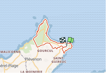
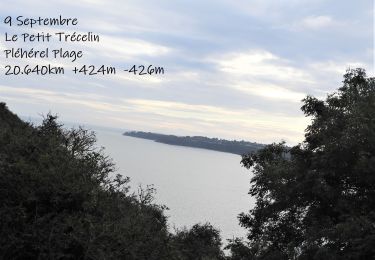
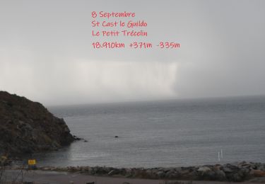
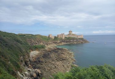
Randonnée Marche de 13,5 km à découvrir à Bretagne, Côtes-d'Armor, Plévenon. Cette randonnée est proposée par selevrich.
Description
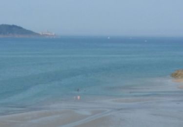
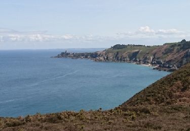
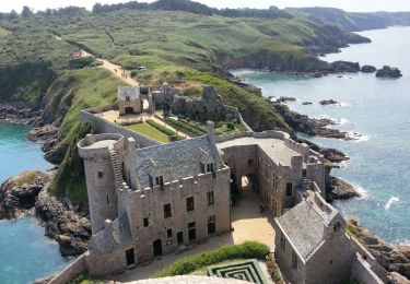
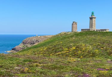
au fil de cette randonnée on découvrira la superbe lande de la presqu'île de Fréhel, puis le tronçon exceptionnel du GR 34 entre le cap Fréhel et le fort de la Latte
Localisation
Pays :
France
Région :
Bretagne
Département/Province :
Côtes-d'Armor
Commune :
Plévenon
Localité :
Unknown
Départ:(Dec)
Départ:(UTM)
552115 ; 5390418 (30U) N.
Commentaires
Randonnées à proximité
![Randonnée Marche Saint-Cast-le-Guildo - 2017-08 St Cast-le Guildo - Photo](https://media.geolcdn.com/t/375/260/ext.jpg?maxdim=2&url=https%3A%2F%2Fservices.sitytrail.com%2FGeolivesWS%2FDownloadMedia.ashx%3FTrailID%3D820107%26Media%3Dfix__20170828153848.jpg)
![Marche Marche](https://static1.geolcdn.com/sitytour/trail-icons/101.png)
2017-08 St Cast-le Guildo
Marche
Facile
(1)
Saint-Cast-le-Guildo,
Bretagne,
Côtes-d'Armor,
France
![](/images/other/stat-length.png)
12,3 km | 15,6 km-effort
3h 28min
![](https://static1.geolcdn.com/siteimages/upload/files/16400158638029165_repeat_loop_refresh_sync_direction_icon.png)
Oui
![Randonnée Marche Plévenon - cap Frehel - Photo](https://media.geolcdn.com/t/375/260/ext.jpg?maxdim=2&url=https%3A%2F%2Fservices.sitytrail.com%2FGeolivesWS%2FDownloadMedia.ashx%3FTrailID%3D733815%26Media%3Dfix__20170416142659.jpg)
![Marche Marche](https://static1.geolcdn.com/sitytour/trail-icons/101.png)
cap Frehel
Marche
Moyen
(1)
Plévenon,
Bretagne,
Côtes-d'Armor,
France
![](/images/other/stat-length.png)
17,2 km | 21 km-effort
4h 43min
![](https://static1.geolcdn.com/siteimages/upload/files/16400158638029165_repeat_loop_refresh_sync_direction_icon.png)
Oui
![Marche Marche](https://static1.geolcdn.com/sitytour/trail-icons/101.png)
N°9 GR34 Le Petit Trécelin -- Pléhérel plage
Marche
Très difficile
Plévenon,
Bretagne,
Côtes-d'Armor,
France
![](/images/other/stat-length.png)
21 km | 26 km-effort
5h 58min
![](https://static1.geolcdn.com/siteimages/upload/files/16400158638029165_repeat_loop_refresh_sync_direction_icon.png)
Non
![Marche Marche](https://static1.geolcdn.com/sitytour/trail-icons/101.png)
N°8 GR34 St Cast le Guildo -- Le Petit Trécelin
Marche
Très difficile
Saint-Cast-le-Guildo,
Bretagne,
Côtes-d'Armor,
France
![](/images/other/stat-length.png)
18,9 km | 24 km-effort
5h 23min
![](https://static1.geolcdn.com/siteimages/upload/files/16400158638029165_repeat_loop_refresh_sync_direction_icon.png)
Non
![Randonnée Marche Plévenon - Plévenon - Fort la Latte - 3.1km 65m 1h00 - 2017 06 22 - Photo](https://media.geolcdn.com/t/375/260/8294287f-801d-42c8-995a-de2105ee0c15.jpg&format=jpg&maxdim=2)
![Marche Marche](https://static1.geolcdn.com/sitytour/trail-icons/101.png)
Plévenon - Fort la Latte - 3.1km 65m 1h00 - 2017 06 22
Marche
Très facile
Plévenon,
Bretagne,
Côtes-d'Armor,
France
![](/images/other/stat-length.png)
3,1 km | 4 km-effort
1h 0min
![](https://static1.geolcdn.com/siteimages/upload/files/16400158638029165_repeat_loop_refresh_sync_direction_icon.png)
Oui
![Randonnée Autre activité Plévenon - Cap Frehel Fort la latte - Photo](https://media.geolcdn.com/t/375/260/ext.jpg?maxdim=2&url=https%3A%2F%2Fstatic1.geolcdn.com%2Fsiteimages%2Fupload%2Ffiles%2F1545311037marcheuse_200dpi.jpg)
![Autre activité Autre activité](https://static1.geolcdn.com/sitytour/trail-icons/900.png)
Cap Frehel Fort la latte
Autre activité
Moyen
(1)
Plévenon,
Bretagne,
Côtes-d'Armor,
France
![](/images/other/stat-length.png)
12,9 km | 15,6 km-effort
4h 41min
![](https://static1.geolcdn.com/siteimages/upload/files/16400158638029165_repeat_loop_refresh_sync_direction_icon.png)
Oui
![Randonnée Marche Plévenon - Cap Frehel - Photo](https://media.geolcdn.com/t/375/260/017eb03e-444e-4bbb-a7dd-b551f9a78235.jpg&format=jpg&maxdim=2)
![Marche Marche](https://static1.geolcdn.com/sitytour/trail-icons/101.png)
Cap Frehel
Marche
Facile
Plévenon,
Bretagne,
Côtes-d'Armor,
France
![](/images/other/stat-length.png)
12,1 km | 14,2 km-effort
4h 28min
![](https://static1.geolcdn.com/siteimages/upload/files/16400158638029165_repeat_loop_refresh_sync_direction_icon.png)
Oui
![Randonnée Marche Plévenon - GR_34_BF_12_Plevenon_Erquy_20230818 - Photo](https://media.geolcdn.com/t/375/260/2759aa01-3305-4693-920a-9eec8c0be183.jpg&format=jpg&maxdim=2)
![Marche Marche](https://static1.geolcdn.com/sitytour/trail-icons/101.png)
GR_34_BF_12_Plevenon_Erquy_20230818
Marche
Facile
Plévenon,
Bretagne,
Côtes-d'Armor,
France
![](/images/other/stat-length.png)
15,5 km | 18,7 km-effort
3h 44min
![](https://static1.geolcdn.com/siteimages/upload/files/16400158638029165_repeat_loop_refresh_sync_direction_icon.png)
Non
![Randonnée Marche Plévenon - Cap Fréhel et Fort la Latte 5.7.23 - Photo](https://media.geolcdn.com/t/375/260/17bf9c44-d657-48b0-aeb2-b0316457cb2f.jpg&format=jpg&maxdim=2)
![Marche Marche](https://static1.geolcdn.com/sitytour/trail-icons/101.png)
Cap Fréhel et Fort la Latte 5.7.23
Marche
Facile
Plévenon,
Bretagne,
Côtes-d'Armor,
France
![](/images/other/stat-length.png)
13,4 km | 16 km-effort
3h 25min
![](https://static1.geolcdn.com/siteimages/upload/files/16400158638029165_repeat_loop_refresh_sync_direction_icon.png)
Oui