![](/images/other/stat-length.png)
![Randonnée Marche Mauchamps - Ecoute s'il pleut - Photo](https://media.geolcdn.com/t/1900/400/60d49545-308d-4742-a760-75374d30d887.jpg&format=pjpeg&maxdim=2)
Ecoute s'il pleut
c.chehere
Utilisateur
![Longueur](/images/other/stat-length.png)
Longueur
18 km
![Altitude max](https://static1.geolcdn.com/siteimages/upload/files/1508320355ic_sort_altitude_max_24dp.png)
Altitude max
160 m
![Dénivelé positif](https://static1.geolcdn.com/siteimages/upload/files/1508320355ic_sort_den_pos_24dp.png)
Dénivelé positif
149 m
![Km-Effort](/images/other/stat-length.png)
Km-Effort
20 km
![Altitude min](https://static1.geolcdn.com/siteimages/upload/files/1508320355ic_sort_altitude_min_24dp.png)
Altitude min
89 m
![Dénivelé négatif](https://static1.geolcdn.com/siteimages/upload/files/1508320355ic_sort_den_neg_24dp.png)
Dénivelé négatif
149 m
![Boucle](https://static1.geolcdn.com/siteimages/upload/files/16400158638029165_repeat_loop_refresh_sync_direction_icon.png)
Boucle
Oui
Date de création :
2021-09-07 07:46:25.634
Dernière modification :
2021-09-07 16:38:58.935
![Marche](https://static1.geolcdn.com/sitytour/trail-icons/101.png)
5h32
Difficulté : Facile
![Scannez ce code QR pour ouvrir la randonnée dans l'application SityTrail](https://capi.geolives.com/qq0zvz2zws4bq2lad0pu/sitytour/trails/2928194/qr.png?size=200)
Application GPS de randonnée GRATUITE
À propos
Randonnée Marche de 18 km à découvrir à Île-de-France, Essonne, Mauchamps. Cette randonnée est proposée par c.chehere.
Description
Pas terrible, rando sur des chemins d'exploitations agricoles tout droits et tout plats.
Seule partie intéressante, la boucle de St Sulpice.
Météo très chaude
Localisation
Pays :
France
Région :
Île-de-France
Département/Province :
Essonne
Commune :
Mauchamps
Localité :
Unknown
Départ:(Dec)
Départ:(UTM)
440454 ; 5375562 (31U) N.
Commentaires
Randonnées à proximité
![Randonnée Marche Lardy - Lardy - Chamarande -F - Photo](https://media.geolcdn.com/t/375/260/ext.jpg?maxdim=2&url=https%3A%2F%2Fservices.sitytrail.com%2FGeolivesWS%2FDownloadMedia.ashx%3FTrailID%3D274259%26Media%3Dfix__20140504142726.jpg)
![Marche Marche](https://static1.geolcdn.com/sitytour/trail-icons/101.png)
Lardy - Chamarande -F
Marche
Moyen
(2)
Lardy,
Île-de-France,
Essonne,
France
![](/images/other/stat-length.png)
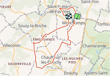
18,3 km | 22 km-effort
4h 44min
![](https://static1.geolcdn.com/siteimages/upload/files/16400158638029165_repeat_loop_refresh_sync_direction_icon.png)
Oui
![Randonnée Marche Saint-Sulpice-de-Favières - Les Pétales de Souzy - Photo](https://media.geolcdn.com/t/375/260/ext.jpg?maxdim=2&url=https%3A%2F%2Fservices.sitytrail.com%2FGeolivesWS%2FDownloadMedia.ashx%3FTrailID%3D110217%26Media%3D5477_1.jpg)
![Marche Marche](https://static1.geolcdn.com/sitytour/trail-icons/101.png)
Les Pétales de Souzy
Marche
Difficile
(1)
Saint-Sulpice-de-Favières,
Île-de-France,
Essonne,
France
![](/images/other/stat-length.png)
23 km | 29 km-effort
4h 49min
![](https://static1.geolcdn.com/siteimages/upload/files/16400158638029165_repeat_loop_refresh_sync_direction_icon.png)
Oui
![Randonnée Marche Lardy - Autour de Lardy par la Pierre levée de Janville sur Juine - Photo](https://media.geolcdn.com/t/375/260/ext.jpg?maxdim=2&url=https%3A%2F%2Fservices.sitytrail.com%2FGeolivesWS%2FDownloadMedia.ashx%3FTrailID%3D110136%26Media%3D5334_1.jpg)
![Marche Marche](https://static1.geolcdn.com/sitytour/trail-icons/101.png)
Autour de Lardy par la Pierre levée de Janville sur Juine
Marche
Difficile
(1)
Lardy,
Île-de-France,
Essonne,
France
![](/images/other/stat-length.png)
24 km | 29 km-effort
4h 49min
![](https://static1.geolcdn.com/siteimages/upload/files/16400158638029165_repeat_loop_refresh_sync_direction_icon.png)
Oui
![Randonnée A pied Étréchy - Linéaire Etrechy - Dourdan - Photo](https://media.geolcdn.com/t/375/260/6933a6b2-3858-4fb1-ab0c-7f731489899d.jpg&format=jpg&maxdim=2)
![A pied A pied](https://static1.geolcdn.com/sitytour/trail-icons/100.png)
Linéaire Etrechy - Dourdan
A pied
Moyen
Étréchy,
Île-de-France,
Essonne,
France
![](/images/other/stat-length.png)
26 km | 31 km-effort
7h 3min
![](https://static1.geolcdn.com/siteimages/upload/files/16400158638029165_repeat_loop_refresh_sync_direction_icon.png)
Non
![Randonnée A pied Saint-Sulpice-de-Favières - Boucle 18 km St Sulpice de Favières - Photo](https://media.geolcdn.com/t/375/260/d7c57897-6d36-438c-b5b4-66e9a4d71ed2.jpg&format=jpg&maxdim=2)
![A pied A pied](https://static1.geolcdn.com/sitytour/trail-icons/100.png)
Boucle 18 km St Sulpice de Favières
A pied
Moyen
Saint-Sulpice-de-Favières,
Île-de-France,
Essonne,
France
![](/images/other/stat-length.png)
18 km | 22 km-effort
4h 59min
![](https://static1.geolcdn.com/siteimages/upload/files/16400158638029165_repeat_loop_refresh_sync_direction_icon.png)
Oui
![Randonnée Marche Chamarande - bois de belvedere au depart de chamarande - Photo](https://media.geolcdn.com/t/375/260/ext.jpg?maxdim=2&url=https%3A%2F%2Fstatic1.geolcdn.com%2Fsiteimages%2Fupload%2Ffiles%2F1553511878bg_sport_marche.png)
![Marche Marche](https://static1.geolcdn.com/sitytour/trail-icons/101.png)
bois de belvedere au depart de chamarande
Marche
Difficile
(1)
Chamarande,
Île-de-France,
Essonne,
France
![](/images/other/stat-length.png)
12,6 km | 17,2 km-effort
3h 54min
![](https://static1.geolcdn.com/siteimages/upload/files/16400158638029165_repeat_loop_refresh_sync_direction_icon.png)
Oui
![Randonnée A pied Saint-Yon - Sur les traces de la Renarde - Photo](https://media.geolcdn.com/t/375/260/422df56a-01d7-491a-a40b-c7b9da63fbd0.jpeg&format=jpg&maxdim=2)
![A pied A pied](https://static1.geolcdn.com/sitytour/trail-icons/100.png)
Sur les traces de la Renarde
A pied
Très difficile
Saint-Yon,
Île-de-France,
Essonne,
France
![](/images/other/stat-length.png)
38 km | 44 km-effort
10h 4min
![](https://static1.geolcdn.com/siteimages/upload/files/16400158638029165_repeat_loop_refresh_sync_direction_icon.png)
Non
![Randonnée Marche Saint-Sulpice-de-Favières - St Sulpice - Photo](https://media.geolcdn.com/t/375/260/ext.jpg?maxdim=2&url=https%3A%2F%2Fstatic1.geolcdn.com%2Fsiteimages%2Fupload%2Ffiles%2F1553511878bg_sport_marche.png)
![Marche Marche](https://static1.geolcdn.com/sitytour/trail-icons/101.png)
St Sulpice
Marche
Moyen
(1)
Saint-Sulpice-de-Favières,
Île-de-France,
Essonne,
France
![](/images/other/stat-length.png)
8 km | 10,1 km-effort
2h 18min
![](https://static1.geolcdn.com/siteimages/upload/files/16400158638029165_repeat_loop_refresh_sync_direction_icon.png)
Oui
![Randonnée Marche Boissy-sous-Saint-Yon - Carrière de Madagascar - Photo](https://media.geolcdn.com/t/375/260/ext.jpg?maxdim=2&url=https%3A%2F%2Fstatic1.geolcdn.com%2Fsiteimages%2Fupload%2Ffiles%2F1553511878bg_sport_marche.png)
![Marche Marche](https://static1.geolcdn.com/sitytour/trail-icons/101.png)
Carrière de Madagascar
Marche
Très facile
(1)
Boissy-sous-Saint-Yon,
Île-de-France,
Essonne,
France
![](/images/other/stat-length.png)
13,2 km | 16,5 km-effort
2h 59min
![](https://static1.geolcdn.com/siteimages/upload/files/16400158638029165_repeat_loop_refresh_sync_direction_icon.png)
Oui