![](/images/other/stat-length.png)
![Randonnée Marche Valdeblore - Baus de la Frema de Colmiane - Photo](https://media.geolcdn.com/t/1900/400/434ffd19-f0b8-4773-ad6b-b19e13f9537a.jpg&format=pjpeg&maxdim=2)
Baus de la Frema de Colmiane
GrouGary
Utilisateur
![Longueur](/images/other/stat-length.png)
Longueur
8 km
![Altitude max](https://static1.geolcdn.com/siteimages/upload/files/1508320355ic_sort_altitude_max_24dp.png)
Altitude max
2225 m
![Dénivelé positif](https://static1.geolcdn.com/siteimages/upload/files/1508320355ic_sort_den_pos_24dp.png)
Dénivelé positif
643 m
![Km-Effort](/images/other/stat-length.png)
Km-Effort
16,5 km
![Altitude min](https://static1.geolcdn.com/siteimages/upload/files/1508320355ic_sort_altitude_min_24dp.png)
Altitude min
1578 m
![Dénivelé négatif](https://static1.geolcdn.com/siteimages/upload/files/1508320355ic_sort_den_neg_24dp.png)
Dénivelé négatif
642 m
![Boucle](https://static1.geolcdn.com/siteimages/upload/files/16400158638029165_repeat_loop_refresh_sync_direction_icon.png)
Boucle
Oui
Date de création :
2021-09-05 06:57:00.529
Dernière modification :
2021-09-05 16:56:23.3
![Marche](https://static1.geolcdn.com/sitytour/trail-icons/101.png)
3h00
Difficulté : Facile
![Scannez ce code QR pour ouvrir la randonnée dans l'application SityTrail](https://capi.geolives.com/qq0zvz2zws4bq2lad0pu/sitytour/trails/2925506/qr.png?size=200)
Application GPS de randonnée GRATUITE
À propos
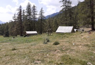
Randonnée Marche de 8 km à découvrir à Provence-Alpes-Côte d'Azur, Alpes-Maritimes, Valdeblore. Cette randonnée est proposée par GrouGary.
Description
A/R. Sentier parfois très raviné lors de la tempête Alex de 2020.
Pepoiri et Petoumier sous un bonnet de brumes.
Vaches et chevaux un peu au-dessus du col
Localisation
Pays :
France
Région :
Provence-Alpes-Côte d'Azur
Département/Province :
Alpes-Maritimes
Commune :
Valdeblore
Localité :
Unknown
Départ:(Dec)
Départ:(UTM)
358264 ; 4881703 (32T) N.
Commentaires
Randonnées à proximité
![Randonnée Marche Valdeblore - pepoiri - Photo](https://media.geolcdn.com/t/375/260/8ca18259-e53b-4625-8dc3-3afb9e53eb6b.jpg&format=jpg&maxdim=2)
![Marche Marche](https://static1.geolcdn.com/sitytour/trail-icons/101.png)
pepoiri
Marche
Très facile
(1)
Valdeblore,
Provence-Alpes-Côte d'Azur,
Alpes-Maritimes,
France
![](/images/other/stat-length.png)
7,8 km | 16,3 km-effort
5h 31min
![](https://static1.geolcdn.com/siteimages/upload/files/16400158638029165_repeat_loop_refresh_sync_direction_icon.png)
Oui
![Randonnée Marche Venanson - La Malouna - Photo](https://media.geolcdn.com/t/375/260/ext.jpg?maxdim=2&url=https%3A%2F%2Fservices.sitytrail.com%2FGeolivesWS%2FDownloadMedia.ashx%3FTrailID%3D405887%26Media%3Dfix__20150409152656.jpg)
![Marche Marche](https://static1.geolcdn.com/sitytour/trail-icons/101.png)
La Malouna
Marche
Moyen
(1)
Venanson,
Provence-Alpes-Côte d'Azur,
Alpes-Maritimes,
France
![](/images/other/stat-length.png)
10,7 km | 17,9 km-effort
5h 20min
![](https://static1.geolcdn.com/siteimages/upload/files/16400158638029165_repeat_loop_refresh_sync_direction_icon.png)
Oui
![Randonnée A pied Valdeblore - Le Caïre Gros - Photo](https://media.geolcdn.com/t/375/260/3c6df4dd-1089-48da-8830-4c0973863251.jpeg&format=jpg&maxdim=2)
![A pied A pied](https://static1.geolcdn.com/sitytour/trail-icons/100.png)
Le Caïre Gros
A pied
Moyen
Valdeblore,
Provence-Alpes-Côte d'Azur,
Alpes-Maritimes,
France
![](/images/other/stat-length.png)
9,8 km | 20 km-effort
4h 38min
![](https://static1.geolcdn.com/siteimages/upload/files/16400158638029165_repeat_loop_refresh_sync_direction_icon.png)
Oui
![Randonnée A pied Saint-Martin-Vésubie - Col de Cerise - Photo](https://media.geolcdn.com/t/375/260/90b1ce11-d155-4ca1-8f15-a1d1ec21efc7.jpeg&format=jpg&maxdim=2)
![A pied A pied](https://static1.geolcdn.com/sitytour/trail-icons/100.png)
Col de Cerise
A pied
Moyen
Saint-Martin-Vésubie,
Provence-Alpes-Côte d'Azur,
Alpes-Maritimes,
France
![](/images/other/stat-length.png)
9,7 km | 23 km-effort
5h 18min
![](https://static1.geolcdn.com/siteimages/upload/files/16400158638029165_repeat_loop_refresh_sync_direction_icon.png)
Oui
![Randonnée A pied Venanson - Circuit du Conquet - Photo](https://media.geolcdn.com/t/375/260/e58595d6-e9ca-4e12-a313-f11c5e4c7d45.jpeg&format=jpg&maxdim=2)
![A pied A pied](https://static1.geolcdn.com/sitytour/trail-icons/100.png)
Circuit du Conquet
A pied
Moyen
Venanson,
Provence-Alpes-Côte d'Azur,
Alpes-Maritimes,
France
![](/images/other/stat-length.png)
10,2 km | 21 km-effort
4h 45min
![](https://static1.geolcdn.com/siteimages/upload/files/16400158638029165_repeat_loop_refresh_sync_direction_icon.png)
Oui
![Marche Marche](https://static1.geolcdn.com/sitytour/trail-icons/101.png)
Lac de Trécolpas - Pas des Ladres - refuge de Cougourde
Marche
Très difficile
Saint-Martin-Vésubie,
Provence-Alpes-Côte d'Azur,
Alpes-Maritimes,
France
![](/images/other/stat-length.png)
17 km | 30 km-effort
5h 45min
![](https://static1.geolcdn.com/siteimages/upload/files/16400158638029165_repeat_loop_refresh_sync_direction_icon.png)
Oui
![Randonnée Marche Valdeblore - Les Lacs des Millefonts (Variante) - Photo](https://media.geolcdn.com/t/375/260/9ec3a33c-746a-4f95-a3bf-1bc95c27318a.jpg&format=jpg&maxdim=2)
![Marche Marche](https://static1.geolcdn.com/sitytour/trail-icons/101.png)
Les Lacs des Millefonts (Variante)
Marche
Difficile
Valdeblore,
Provence-Alpes-Côte d'Azur,
Alpes-Maritimes,
France
![](/images/other/stat-length.png)
10,1 km | 19,4 km-effort
4h 5min
![](https://static1.geolcdn.com/siteimages/upload/files/16400158638029165_repeat_loop_refresh_sync_direction_icon.png)
Oui
![Randonnée Marche Saint-Martin-Vésubie - Tour de la Vallée du Boréon - Photo](https://media.geolcdn.com/t/375/260/c27c6217-906b-4fb0-92a6-1ad8d294a181.jpg&format=jpg&maxdim=2)
![Marche Marche](https://static1.geolcdn.com/sitytour/trail-icons/101.png)
Tour de la Vallée du Boréon
Marche
Difficile
Saint-Martin-Vésubie,
Provence-Alpes-Côte d'Azur,
Alpes-Maritimes,
France
![](/images/other/stat-length.png)
15,2 km | 26 km-effort
4h 45min
![](https://static1.geolcdn.com/siteimages/upload/files/16400158638029165_repeat_loop_refresh_sync_direction_icon.png)
Oui
![Randonnée Ski de randonnée Valdeblore - Pèpoiri et Petoumier - Photo](https://media.geolcdn.com/t/375/260/b5f7f954-f6d6-45d0-b44a-3f93e1cb0060.jpg&format=jpg&maxdim=2)
![Ski de randonnée Ski de randonnée](https://static1.geolcdn.com/sitytour/trail-icons/503.png)
Pèpoiri et Petoumier
Ski de randonnée
Moyen
Valdeblore,
Provence-Alpes-Côte d'Azur,
Alpes-Maritimes,
France
![](/images/other/stat-length.png)
12,8 km | 31 km-effort
6h 44min
![](https://static1.geolcdn.com/siteimages/upload/files/16400158638029165_repeat_loop_refresh_sync_direction_icon.png)
Oui