![](/images/other/stat-length.png)
![Randonnée Marche Val-d'Arc - la chapelle de montsap' - Photo](https://media.geolcdn.com/t/1900/400/ext.pjpeg?maxdim=2&url=https%3A%2F%2Fstatic1.geolcdn.com%2Fsiteimages%2Fupload%2Ffiles%2F1553511878bg_sport_marche.png)
la chapelle de montsap'
jibebouvier
Utilisateur
![Longueur](/images/other/stat-length.png)
Longueur
11,1 km
![Altitude max](https://static1.geolcdn.com/siteimages/upload/files/1508320355ic_sort_altitude_max_24dp.png)
Altitude max
1035 m
![Dénivelé positif](https://static1.geolcdn.com/siteimages/upload/files/1508320355ic_sort_den_pos_24dp.png)
Dénivelé positif
807 m
![Km-Effort](/images/other/stat-length.png)
Km-Effort
22 km
![Altitude min](https://static1.geolcdn.com/siteimages/upload/files/1508320355ic_sort_altitude_min_24dp.png)
Altitude min
321 m
![Dénivelé négatif](https://static1.geolcdn.com/siteimages/upload/files/1508320355ic_sort_den_neg_24dp.png)
Dénivelé négatif
812 m
![Boucle](https://static1.geolcdn.com/siteimages/upload/files/16400158638029165_repeat_loop_refresh_sync_direction_icon.png)
Boucle
Oui
Date de création :
2021-09-05 05:49:04.539
Dernière modification :
2021-09-05 08:46:33.879
![Marche](https://static1.geolcdn.com/sitytour/trail-icons/101.png)
2h30
Difficulté : Moyen
![Scannez ce code QR pour ouvrir la randonnée dans l'application SityTrail](https://capi.geolives.com/qq0zvz2zws4bq2lad0pu/sitytour/trails/2925169/qr.png?size=200)
Application GPS de randonnée GRATUITE
À propos
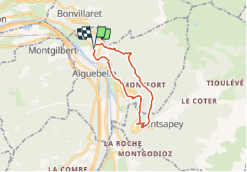
Randonnée Marche de 11,1 km à découvrir à Auvergne-Rhône-Alpes, Savoie, Val-d'Arc. Cette randonnée est proposée par jibebouvier.
Description
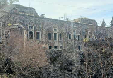
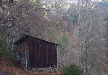
l'aller par le chemin habituel, le retour, en fait le chemin n'existe plus, ligne électrique qui touche terre, ronciers etc...
soit redescendre par le même chemin soit par le chaudron puis Argentine
Localisation
Pays :
France
Région :
Auvergne-Rhône-Alpes
Département/Province :
Savoie
Commune :
Val-d'Arc
Localité :
Randens
Départ:(Dec)
Départ:(UTM)
289723 ; 5047586 (32T) N.
Commentaires
Randonnées à proximité
![Randonnée Marche Montsapey - Lac Clartan et plus - Photo](https://media.geolcdn.com/t/375/260/a3945484-2742-42e9-b6c0-fb5c4b25df2b.jpg&format=jpg&maxdim=2)
![Marche Marche](https://static1.geolcdn.com/sitytour/trail-icons/101.png)
Lac Clartan et plus
Marche
Moyen
Montsapey,
Auvergne-Rhône-Alpes,
Savoie,
France
![](/images/other/stat-length.png)
7,4 km | 21 km-effort
2h 46min
![](https://static1.geolcdn.com/siteimages/upload/files/16400158638029165_repeat_loop_refresh_sync_direction_icon.png)
Non
![Randonnée Ski de randonnée Montsapey - pas de Freydon - Photo](https://media.geolcdn.com/t/375/260/878ecc25-aa9c-40b4-b58b-a735c66cffef.jpg&format=jpg&maxdim=2)
![Ski de randonnée Ski de randonnée](https://static1.geolcdn.com/sitytour/trail-icons/503.png)
pas de Freydon
Ski de randonnée
Moyen
Montsapey,
Auvergne-Rhône-Alpes,
Savoie,
France
![](/images/other/stat-length.png)
13,6 km | 34 km-effort
7h 37min
![](https://static1.geolcdn.com/siteimages/upload/files/16400158638029165_repeat_loop_refresh_sync_direction_icon.png)
Oui
![Randonnée Marche Val-d'Arc - Grand Arc - Photo](https://media.geolcdn.com/t/375/260/ext.jpg?maxdim=2&url=https%3A%2F%2Fstatic1.geolcdn.com%2Fsiteimages%2Fupload%2Ffiles%2F1553511878bg_sport_marche.png)
![Marche Marche](https://static1.geolcdn.com/sitytour/trail-icons/101.png)
Grand Arc
Marche
Très difficile
(1)
Val-d'Arc,
Auvergne-Rhône-Alpes,
Savoie,
France
![](/images/other/stat-length.png)
7,7 km | 28 km-effort
5h 0min
![](https://static1.geolcdn.com/siteimages/upload/files/16400158638029165_repeat_loop_refresh_sync_direction_icon.png)
Non
![Randonnée Marche Montsapey - portes de Montmélian par le col des fretes - Photo](https://media.geolcdn.com/t/375/260/90286a5c-8381-4fdf-9211-0d4b99111163.jpg&format=jpg&maxdim=2)
![Marche Marche](https://static1.geolcdn.com/sitytour/trail-icons/101.png)
portes de Montmélian par le col des fretes
Marche
Difficile
Montsapey,
Auvergne-Rhône-Alpes,
Savoie,
France
![](/images/other/stat-length.png)
11,5 km | 29 km-effort
4h 7min
![](https://static1.geolcdn.com/siteimages/upload/files/16400158638029165_repeat_loop_refresh_sync_direction_icon.png)
Oui
![Randonnée Marche Montgilbert - les batteries par Montgilbert - Photo](https://media.geolcdn.com/t/375/260/f104cb28-96a4-49e7-af5f-60f831324464.jpg&format=jpg&maxdim=2)
![Marche Marche](https://static1.geolcdn.com/sitytour/trail-icons/101.png)
les batteries par Montgilbert
Marche
Facile
Montgilbert,
Auvergne-Rhône-Alpes,
Savoie,
France
![](/images/other/stat-length.png)
11,5 km | 19,5 km-effort
3h 10min
![](https://static1.geolcdn.com/siteimages/upload/files/16400158638029165_repeat_loop_refresh_sync_direction_icon.png)
Oui
![Randonnée Marche Sainte-Hélène-sur-Isère - 27 09 23 le Grand Arc - Photo](https://media.geolcdn.com/t/375/260/06827bae-7a14-40e2-996f-75ece7e1ce9b.jpg&format=jpg&maxdim=2)
![Marche Marche](https://static1.geolcdn.com/sitytour/trail-icons/101.png)
27 09 23 le Grand Arc
Marche
Très difficile
Sainte-Hélène-sur-Isère,
Auvergne-Rhône-Alpes,
Savoie,
France
![](/images/other/stat-length.png)
9,4 km | 19,8 km-effort
4h 5min
![](https://static1.geolcdn.com/siteimages/upload/files/16400158638029165_repeat_loop_refresh_sync_direction_icon.png)
Non
![Randonnée Marche Sainte-Hélène-sur-Isère - 26 09 23 la dent du corbeau par la grande lanche - Photo](https://media.geolcdn.com/t/375/260/87de882e-a65f-4159-b9ac-8bc46446cbc4.jpg&format=jpg&maxdim=2)
![Marche Marche](https://static1.geolcdn.com/sitytour/trail-icons/101.png)
26 09 23 la dent du corbeau par la grande lanche
Marche
Difficile
Sainte-Hélène-sur-Isère,
Auvergne-Rhône-Alpes,
Savoie,
France
![](/images/other/stat-length.png)
10,5 km | 22 km-effort
4h 12min
![](https://static1.geolcdn.com/siteimages/upload/files/16400158638029165_repeat_loop_refresh_sync_direction_icon.png)
Oui
![Randonnée Marche Montsapey - petit arc par bataille dessus printemps - Photo](https://media.geolcdn.com/t/375/260/3bc7f631-fc7c-488f-b081-67d83a0e2dae.jpg&format=jpg&maxdim=2)
![Marche Marche](https://static1.geolcdn.com/sitytour/trail-icons/101.png)
petit arc par bataille dessus printemps
Marche
Difficile
Montsapey,
Auvergne-Rhône-Alpes,
Savoie,
France
![](/images/other/stat-length.png)
9,2 km | 22 km-effort
4h 29min
![](https://static1.geolcdn.com/siteimages/upload/files/16400158638029165_repeat_loop_refresh_sync_direction_icon.png)
Oui
![Randonnée Marche Val-d'Arc - tour du haut de Randens - Photo](https://media.geolcdn.com/t/375/260/aa8a7963-0ce0-4bad-bb6f-4b975d8a3b5b.jpg&format=jpg&maxdim=2)
![Marche Marche](https://static1.geolcdn.com/sitytour/trail-icons/101.png)
tour du haut de Randens
Marche
Moyen
Val-d'Arc,
Auvergne-Rhône-Alpes,
Savoie,
France
![](/images/other/stat-length.png)
13 km | 31 km-effort
2h 48min
![](https://static1.geolcdn.com/siteimages/upload/files/16400158638029165_repeat_loop_refresh_sync_direction_icon.png)
Oui