![](/images/other/stat-length.png)
![Randonnée Marche Saint-Antonin-du-Var - Circuit des Colles - Photo](https://media.geolcdn.com/t/1900/400/ext.pjpeg?maxdim=2&url=https%3A%2F%2Fstatic1.geolcdn.com%2Fsiteimages%2Fupload%2Ffiles%2F1553511878bg_sport_marche.png)
Circuit des Colles
Chantheys
Utilisateur
![Longueur](/images/other/stat-length.png)
Longueur
9,8 km
![Altitude max](https://static1.geolcdn.com/siteimages/upload/files/1508320355ic_sort_altitude_max_24dp.png)
Altitude max
317 m
![Dénivelé positif](https://static1.geolcdn.com/siteimages/upload/files/1508320355ic_sort_den_pos_24dp.png)
Dénivelé positif
262 m
![Km-Effort](/images/other/stat-length.png)
Km-Effort
13,3 km
![Altitude min](https://static1.geolcdn.com/siteimages/upload/files/1508320355ic_sort_altitude_min_24dp.png)
Altitude min
160 m
![Dénivelé négatif](https://static1.geolcdn.com/siteimages/upload/files/1508320355ic_sort_den_neg_24dp.png)
Dénivelé négatif
259 m
![Boucle](https://static1.geolcdn.com/siteimages/upload/files/16400158638029165_repeat_loop_refresh_sync_direction_icon.png)
Boucle
Oui
Date de création :
2021-08-30 07:39:26.711
Dernière modification :
2024-10-14 00:26:45.437
![Marche](https://static1.geolcdn.com/sitytour/trail-icons/101.png)
3h00
Difficulté : Difficile
![Scannez ce code QR pour ouvrir la randonnée dans l'application SityTrail](https://capi.geolives.com/qq0zvz2zws4bq2lad0pu/sitytour/trails/2918786/qr.png?size=200)
Application GPS de randonnée GRATUITE
À propos
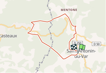
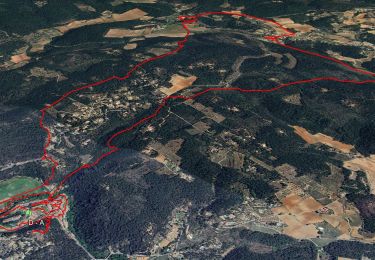
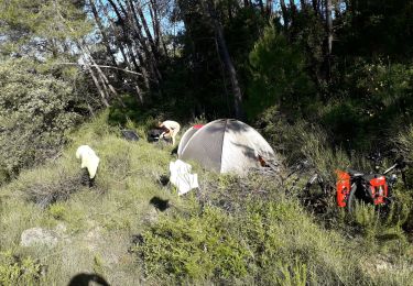
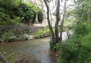
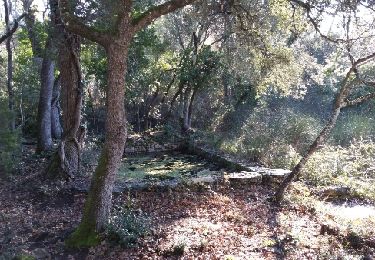
Randonnée Marche de 9,8 km à découvrir à Provence-Alpes-Côte d'Azur, Var, Saint-Antonin-du-Var. Cette randonnée est proposée par Chantheys.
Description
Inspiré du fascicule "7 balades au départ de Saint-Antonin"(www.saintantoninduvar.com) ajout d'un tracé gps
Localisation
Pays :
France
Région :
Provence-Alpes-Côte d'Azur
Département/Province :
Var
Commune :
Saint-Antonin-du-Var
Localité :
Unknown
Départ:(Dec)
Départ:(UTM)
280721 ; 4820657 (32T) N.
Commentaires
Randonnées à proximité
![Randonnée sport Saint-Antonin-du-Var - 2024-02-05_17h29m21_st antonin demain - Photo](https://media.geolcdn.com/t/375/260/ext.jpg?maxdim=2&url=https%3A%2F%2Fsecurestorage.geolives.com%2Fsitytour%2Ftrail-bg%2Fdefault.jpg)
2024-02-05_17h29m21_st antonin demain
sport
Très facile
(1)
Saint-Antonin-du-Var,
Provence-Alpes-Côte d'Azur,
Var,
France
![](/images/other/stat-length.png)
27 km | 35 km-effort
Inconnu
![](https://static1.geolcdn.com/siteimages/upload/files/16400158638029165_repeat_loop_refresh_sync_direction_icon.png)
Oui
![Randonnée Marche Entrecasteaux - 2023-11-28 Encastreaux Mentone - Photo](https://media.geolcdn.com/t/375/260/55d6a213-bd6e-43cc-a50c-f4aedf4623ce.jpg&format=jpg&maxdim=2)
![Marche Marche](https://static1.geolcdn.com/sitytour/trail-icons/101.png)
2023-11-28 Encastreaux Mentone
Marche
Moyen
Entrecasteaux,
Provence-Alpes-Côte d'Azur,
Var,
France
![](/images/other/stat-length.png)
15,5 km | 22 km-effort
4h 54min
![](https://static1.geolcdn.com/siteimages/upload/files/16400158638029165_repeat_loop_refresh_sync_direction_icon.png)
Oui
![Randonnée Marche Entrecasteaux - Entrecasteaux - Photo](https://media.geolcdn.com/t/375/260/e3754524-1b1b-4fbb-8572-3a4b34c7ddfe.jpg&format=jpg&maxdim=2)
![Marche Marche](https://static1.geolcdn.com/sitytour/trail-icons/101.png)
Entrecasteaux
Marche
Facile
Entrecasteaux,
Provence-Alpes-Côte d'Azur,
Var,
France
![](/images/other/stat-length.png)
16,1 km | 23 km-effort
6h 0min
![](https://static1.geolcdn.com/siteimages/upload/files/16400158638029165_repeat_loop_refresh_sync_direction_icon.png)
Oui
![Randonnée Marche Entrecasteaux - entrecastaux / mentonne - Photo](https://media.geolcdn.com/t/375/260/43adbfcf-5c5e-44a6-81ff-e17e6520c91e.jpg&format=jpg&maxdim=2)
![Marche Marche](https://static1.geolcdn.com/sitytour/trail-icons/101.png)
entrecastaux / mentonne
Marche
Facile
Entrecasteaux,
Provence-Alpes-Côte d'Azur,
Var,
France
![](/images/other/stat-length.png)
14,3 km | 19,6 km-effort
3h 42min
![](https://static1.geolcdn.com/siteimages/upload/files/16400158638029165_repeat_loop_refresh_sync_direction_icon.png)
Oui
![Randonnée Marche Entrecasteaux - Entrecasteaux - Photo](https://media.geolcdn.com/t/375/260/959802ef-ad7e-4cb2-8ce2-e529d3140213.jpg&format=jpg&maxdim=2)
![Marche Marche](https://static1.geolcdn.com/sitytour/trail-icons/101.png)
Entrecasteaux
Marche
Moyen
Entrecasteaux,
Provence-Alpes-Côte d'Azur,
Var,
France
![](/images/other/stat-length.png)
13,9 km | 19 km-effort
4h 49min
![](https://static1.geolcdn.com/siteimages/upload/files/16400158638029165_repeat_loop_refresh_sync_direction_icon.png)
Oui
![Randonnée Marche Saint-Antonin-du-Var - SAINT-ANTONIN DU VAR - ENTRE MENTONE ET SALERNES - Photo](https://media.geolcdn.com/t/375/260/79146983-c6e4-4d99-8b7e-7782eba7f484.jpg&format=jpg&maxdim=2)
![Marche Marche](https://static1.geolcdn.com/sitytour/trail-icons/101.png)
SAINT-ANTONIN DU VAR - ENTRE MENTONE ET SALERNES
Marche
Facile
Saint-Antonin-du-Var,
Provence-Alpes-Côte d'Azur,
Var,
France
![](/images/other/stat-length.png)
15,2 km | 19,7 km-effort
5h 13min
![](https://static1.geolcdn.com/siteimages/upload/files/16400158638029165_repeat_loop_refresh_sync_direction_icon.png)
Oui
![Randonnée Cyclotourisme Entrecasteaux - 83 Var Salernes à Callas J2/6 - Photo](https://media.geolcdn.com/t/375/260/db54e772-40da-4043-9a2d-62a60e0d430f.jpg&format=jpg&maxdim=2)
![Cyclotourisme Cyclotourisme](https://static1.geolcdn.com/sitytour/trail-icons/204.png)
83 Var Salernes à Callas J2/6
Cyclotourisme
Moyen
Entrecasteaux,
Provence-Alpes-Côte d'Azur,
Var,
France
![](/images/other/stat-length.png)
47 km | 59 km-effort
8h 14min
![](https://static1.geolcdn.com/siteimages/upload/files/16400158638029165_repeat_loop_refresh_sync_direction_icon.png)
Non
![Randonnée Marche Entrecasteaux - Entrecasteaux 20-05-2020 - Photo](https://media.geolcdn.com/t/375/260/d391037a-b05f-4894-9127-bc631cd9629d.jpg&format=jpg&maxdim=2)
![Marche Marche](https://static1.geolcdn.com/sitytour/trail-icons/101.png)
Entrecasteaux 20-05-2020
Marche
Moyen
Entrecasteaux,
Provence-Alpes-Côte d'Azur,
Var,
France
![](/images/other/stat-length.png)
18,7 km | 25 km-effort
4h 36min
![](https://static1.geolcdn.com/siteimages/upload/files/16400158638029165_repeat_loop_refresh_sync_direction_icon.png)
Oui
![Randonnée Marche Lorgues - 20190130 Mentone Est rando réelle. - Photo](https://media.geolcdn.com/t/375/260/ext.jpg?maxdim=2&url=https%3A%2F%2Fservices.sitytrail.com%2FGeolivesWS%2FDownloadMedia.ashx%3FTrailID%3D1104083%26Media%3Dfix__20190130105141.jpg)
![Marche Marche](https://static1.geolcdn.com/sitytour/trail-icons/101.png)
20190130 Mentone Est rando réelle.
Marche
Facile
Lorgues,
Provence-Alpes-Côte d'Azur,
Var,
France
![](/images/other/stat-length.png)
17,4 km | 22 km-effort
4h 40min
![](https://static1.geolcdn.com/siteimages/upload/files/16400158638029165_repeat_loop_refresh_sync_direction_icon.png)
Oui