![](/images/other/stat-length.png)
![Randonnée A pied Gresse-en-Vercors - Un petit tour au Grand Brisou - Photo](https://media.geolcdn.com/t/1900/400/ext.pjpeg?maxdim=2&url=https%3A%2F%2Fstatic1.geolcdn.com%2Fsiteimages%2Fupload%2Ffiles%2F1545311037marcheuse_200dpi.jpg)
Un petit tour au Grand Brisou
Chafoin
Utilisateur
![Longueur](/images/other/stat-length.png)
![Altitude max](https://static1.geolcdn.com/siteimages/upload/files/1508320355ic_sort_altitude_max_24dp.png)
![Dénivelé positif](https://static1.geolcdn.com/siteimages/upload/files/1508320355ic_sort_den_pos_24dp.png)
![Km-Effort](/images/other/stat-length.png)
![Altitude min](https://static1.geolcdn.com/siteimages/upload/files/1508320355ic_sort_altitude_min_24dp.png)
![Dénivelé négatif](https://static1.geolcdn.com/siteimages/upload/files/1508320355ic_sort_den_neg_24dp.png)
![Boucle](https://static1.geolcdn.com/siteimages/upload/files/16400158638029165_repeat_loop_refresh_sync_direction_icon.png)
![A pied](https://static1.geolcdn.com/sitytour/trail-icons/100.png)
3h36
Difficulté : Facile
![Scannez ce code QR pour ouvrir la randonnée dans l'application SityTrail](https://capi.geolives.com/qq0zvz2zws4bq2lad0pu/sitytour/trails/2915963/qr.png?size=200)
Application GPS de randonnée GRATUITE
À propos
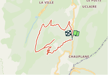
Randonnée A pied de 9,3 km à découvrir à Auvergne-Rhône-Alpes, Isère, Gresse-en-Vercors. Cette randonnée est proposée par Chafoin.
Description
Départ du col de l'Allimas (1352 m) passage au ravin de la Rantanche . Au ravin des Sagnes montée jusqu'à l'arrivée à
1678 m du téléski des Alleyrons .Descente par la crête des Alleyrons. Couper la piste du téléski du Blavet , à la fontaine du Clot remonter vers combe Rouge puis retour au col de l'Allimas
Localisation
Commentaires
Randonnées à proximité
![Randonnée Marche Saint-Michel-les-Portes - Grand Ceymont par la face Sud - Photo](https://media.geolcdn.com/t/375/260/d58be866-4722-407f-9e9c-e7428ea96660.jpg&format=jpg&maxdim=2)
![Marche Marche](https://static1.geolcdn.com/sitytour/trail-icons/101.png)
Marche
![](/images/other/stat-length.png)
![](https://static1.geolcdn.com/siteimages/upload/files/16400158638029165_repeat_loop_refresh_sync_direction_icon.png)
![Randonnée Marche Gresse-en-Vercors - Quinquambaye - crête du Brisou - Photo](https://media.geolcdn.com/t/375/260/686aed71-19ef-4a34-8333-a2b65dd9c4d5.jpg&format=jpg&maxdim=2)
![Marche Marche](https://static1.geolcdn.com/sitytour/trail-icons/101.png)
Marche
![](/images/other/stat-length.png)
![](https://static1.geolcdn.com/siteimages/upload/files/16400158638029165_repeat_loop_refresh_sync_direction_icon.png)
![Randonnée Marche Gresse-en-Vercors - Traversée du Rocher du Baconnet - Photo](https://media.geolcdn.com/t/375/260/ext.jpg?maxdim=2&url=https%3A%2F%2Fservices.sitytrail.com%2FGeolivesWS%2FDownloadMedia.ashx%3FTrailID%3D105962%26Media%3D10040_1.jpg)
![Marche Marche](https://static1.geolcdn.com/sitytour/trail-icons/101.png)
Marche
![](/images/other/stat-length.png)
![](https://static1.geolcdn.com/siteimages/upload/files/16400158638029165_repeat_loop_refresh_sync_direction_icon.png)
![Randonnée Marche Gresse-en-Vercors - traversée Sud nord du Grand Veymont - Photo](https://media.geolcdn.com/t/375/260/3004a1b5-ea0f-48e3-8863-72e77652ad4d.jpg&format=jpg&maxdim=2)
![Marche Marche](https://static1.geolcdn.com/sitytour/trail-icons/101.png)
Marche
![](/images/other/stat-length.png)
![](https://static1.geolcdn.com/siteimages/upload/files/16400158638029165_repeat_loop_refresh_sync_direction_icon.png)
![Randonnée Marche Saint-Michel-les-Portes - Tour du Mont Aiguille - Photo](https://media.geolcdn.com/t/375/260/13641da4-549e-49b9-8e23-d4a17f7e4345.jpg&format=jpg&maxdim=2)
![Marche Marche](https://static1.geolcdn.com/sitytour/trail-icons/101.png)
Marche
![](/images/other/stat-length.png)
![](https://static1.geolcdn.com/siteimages/upload/files/16400158638029165_repeat_loop_refresh_sync_direction_icon.png)
![Randonnée Marche Gresse-en-Vercors - le grand veymont depuis gresse en vercors et par le pas de la ville - Photo](https://media.geolcdn.com/t/375/260/ext.jpg?maxdim=2&url=https%3A%2F%2Fstatic1.geolcdn.com%2Fsiteimages%2Fupload%2Ffiles%2F1553511878bg_sport_marche.png)
![Marche Marche](https://static1.geolcdn.com/sitytour/trail-icons/101.png)
Marche
![](/images/other/stat-length.png)
![](https://static1.geolcdn.com/siteimages/upload/files/16400158638029165_repeat_loop_refresh_sync_direction_icon.png)
![Randonnée Marche Saint-Michel-les-Portes - Pas de Bachassons et de la Selle - Photo](https://media.geolcdn.com/t/375/260/10e42988-cabf-4bc0-8c6b-1118178d695b.jpg&format=jpg&maxdim=2)
![Marche Marche](https://static1.geolcdn.com/sitytour/trail-icons/101.png)
Marche
![](/images/other/stat-length.png)
![](https://static1.geolcdn.com/siteimages/upload/files/16400158638029165_repeat_loop_refresh_sync_direction_icon.png)
![Randonnée Marche Gresse-en-Vercors - Pas de Serpaton et crêtes, de Gresse en Vercors - Photo](https://media.geolcdn.com/t/375/260/184f68f2-62ff-4093-8bd0-69314b118936.jpg&format=jpg&maxdim=2)
![Marche Marche](https://static1.geolcdn.com/sitytour/trail-icons/101.png)
Marche
![](/images/other/stat-length.png)
![](https://static1.geolcdn.com/siteimages/upload/files/16400158638029165_repeat_loop_refresh_sync_direction_icon.png)
![Randonnée Marche Gresse-en-Vercors - Grand Veymond de Gresse en Vercors - Photo](https://media.geolcdn.com/t/375/260/2232aaa5-57f5-4754-96ce-b8c8c04af563.jpg&format=jpg&maxdim=2)
![Marche Marche](https://static1.geolcdn.com/sitytour/trail-icons/101.png)
Marche
![](/images/other/stat-length.png)
![](https://static1.geolcdn.com/siteimages/upload/files/16400158638029165_repeat_loop_refresh_sync_direction_icon.png)