![](/images/other/stat-length.png)
![Randonnée Marche Cervières - Le Grand Gleiza - Photo](https://media.geolcdn.com/t/1900/400/ext.pjpeg?maxdim=2&url=https%3A%2F%2Fstatic1.geolcdn.com%2Fsiteimages%2Fupload%2Ffiles%2F1553511878bg_sport_marche.png)
Le Grand Gleiza
Dervalmarc
Utilisateur
![Longueur](/images/other/stat-length.png)
![Altitude max](https://static1.geolcdn.com/siteimages/upload/files/1508320355ic_sort_altitude_max_24dp.png)
![Dénivelé positif](https://static1.geolcdn.com/siteimages/upload/files/1508320355ic_sort_den_pos_24dp.png)
![Km-Effort](/images/other/stat-length.png)
![Altitude min](https://static1.geolcdn.com/siteimages/upload/files/1508320355ic_sort_altitude_min_24dp.png)
![Dénivelé négatif](https://static1.geolcdn.com/siteimages/upload/files/1508320355ic_sort_den_neg_24dp.png)
![Boucle](https://static1.geolcdn.com/siteimages/upload/files/16400158638029165_repeat_loop_refresh_sync_direction_icon.png)
![Marche](https://static1.geolcdn.com/sitytour/trail-icons/101.png)
22h34
Difficulté : Très difficile
![Scannez ce code QR pour ouvrir la randonnée dans l'application SityTrail](https://capi.geolives.com/qq0zvz2zws4bq2lad0pu/sitytour/trails/2914264/qr.png?size=200)
Application GPS de randonnée GRATUITE
À propos
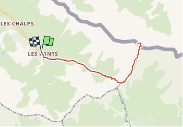
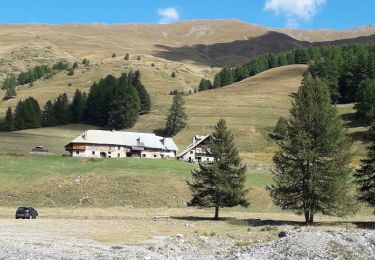
Randonnée Marche de 15,8 km à découvrir à Provence-Alpes-Côte d'Azur, Hautes-Alpes, Cervières. Cette randonnée est proposée par Dervalmarc.
Description
Très longue randonnée.
20 kilomètres.
Très variée.2 cimes, deux col.
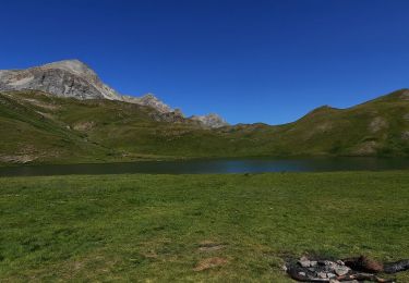
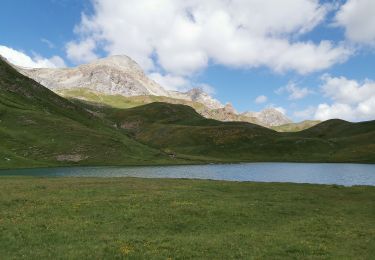
Vue sur le grand lac du Laus.
Compter entre huit et 10 heures de marche arrêts non compris.
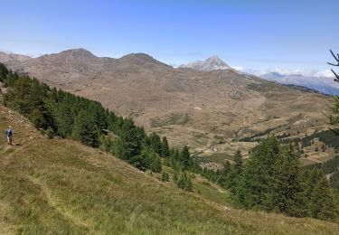
Panorama exceptionnel bien mérité après une ascension exigeante.
Compter 10h de marche et non 22h37
Localisation
Commentaires
Randonnées à proximité
![Randonnée Marche Cervières - Le Petit rochebrune par col de péas - Photo](https://media.geolcdn.com/t/375/260/e12553c6-5b67-4a21-b5b9-83e83e9c9741.jpg&format=jpg&maxdim=2)
![Marche Marche](https://static1.geolcdn.com/sitytour/trail-icons/101.png)
Marche
![](/images/other/stat-length.png)
![](https://static1.geolcdn.com/siteimages/upload/files/16400158638029165_repeat_loop_refresh_sync_direction_icon.png)
![Randonnée Marche Cervières - le lac des Cordes et le pic du vallon Crouzet - Photo](https://media.geolcdn.com/t/375/260/ext.jpg?maxdim=2&url=https%3A%2F%2Fservices.sitytrail.com%2FGeolivesWS%2FDownloadMedia.ashx%3FTrailID%3D787861%26Media%3Dfix__20170710153913.jpg)
![Marche Marche](https://static1.geolcdn.com/sitytour/trail-icons/101.png)
Marche
![](/images/other/stat-length.png)
![](https://static1.geolcdn.com/siteimages/upload/files/16400158638029165_repeat_loop_refresh_sync_direction_icon.png)
![Randonnée Marche Cervières - Circuit du Lac des Cordes - Photo](https://media.geolcdn.com/t/375/260/773a9233-b719-442d-b7b1-75196ce74f87.jpg&format=jpg&maxdim=2)
![Marche Marche](https://static1.geolcdn.com/sitytour/trail-icons/101.png)
Marche
![](/images/other/stat-length.png)
![](https://static1.geolcdn.com/siteimages/upload/files/16400158638029165_repeat_loop_refresh_sync_direction_icon.png)
![Randonnée Ski de randonnée Cervières - PT 2944 crête de Dormillouse - Photo](https://media.geolcdn.com/t/375/260/9199c634-7f71-48f6-bcd5-441d1eaab9cb.jpg&format=jpg&maxdim=2)
![Ski de randonnée Ski de randonnée](https://static1.geolcdn.com/sitytour/trail-icons/503.png)
Ski de randonnée
![](/images/other/stat-length.png)
![](https://static1.geolcdn.com/siteimages/upload/files/16400158638029165_repeat_loop_refresh_sync_direction_icon.png)
![Randonnée Marche Cervières - le lasseron col de chaude maison - Photo](https://media.geolcdn.com/t/375/260/a0498023-fd7f-45a6-ba40-c354c806ca60.jpg&format=jpg&maxdim=2)
![Marche Marche](https://static1.geolcdn.com/sitytour/trail-icons/101.png)
Marche
![](/images/other/stat-length.png)
![](https://static1.geolcdn.com/siteimages/upload/files/16400158638029165_repeat_loop_refresh_sync_direction_icon.png)
![Randonnée Marche Cervières - Le Lac des cordes - Photo](https://media.geolcdn.com/t/375/260/4677ed4c-abf4-4114-9dfd-57192ba7a290.jpg&format=jpg&maxdim=2)
![Marche Marche](https://static1.geolcdn.com/sitytour/trail-icons/101.png)
Marche
![](/images/other/stat-length.png)
![](https://static1.geolcdn.com/siteimages/upload/files/16400158638029165_repeat_loop_refresh_sync_direction_icon.png)
![Randonnée Marche Cervières - Arsem Les fonts de Cervieres - Photo](https://media.geolcdn.com/t/375/260/1c663feb-cf6d-4c05-adc4-11e78d8381cd.jpg&format=jpg&maxdim=2)
![Marche Marche](https://static1.geolcdn.com/sitytour/trail-icons/101.png)
Marche
![](/images/other/stat-length.png)
![](https://static1.geolcdn.com/siteimages/upload/files/16400158638029165_repeat_loop_refresh_sync_direction_icon.png)
![Randonnée Luge Cervières - refuge Les Fonts à Chalp - Photo](https://media.geolcdn.com/t/375/260/1095cc6d-0fa6-427a-8540-75f35ae6c8dc.jpg&format=jpg&maxdim=2)
![Luge Luge](https://static1.geolcdn.com/sitytour/trail-icons/506.png)
Luge
![](/images/other/stat-length.png)
![](https://static1.geolcdn.com/siteimages/upload/files/16400158638029165_repeat_loop_refresh_sync_direction_icon.png)
![Randonnée Marche Cervières - Lac des Cordes - Photo](https://media.geolcdn.com/t/375/260/89c8f3fc-bf2f-4ed0-a763-182170a8be7f.jpg&format=jpg&maxdim=2)
![Marche Marche](https://static1.geolcdn.com/sitytour/trail-icons/101.png)
Marche
![](/images/other/stat-length.png)
![](https://static1.geolcdn.com/siteimages/upload/files/16400158638029165_repeat_loop_refresh_sync_direction_icon.png)