![](/images/other/stat-length.png)
![Randonnée Marche Mercuès - Martine/Bernard - Photo](https://media.geolcdn.com/t/1900/400/ext.pjpeg?maxdim=2&url=https%3A%2F%2Fstatic1.geolcdn.com%2Fsiteimages%2Fupload%2Ffiles%2F1553511878bg_sport_marche.png)
Martine/Bernard
Marc51
Utilisateur
![Longueur](/images/other/stat-length.png)
Longueur
4,2 km
![Altitude max](https://static1.geolcdn.com/siteimages/upload/files/1508320355ic_sort_altitude_max_24dp.png)
Altitude max
174 m
![Dénivelé positif](https://static1.geolcdn.com/siteimages/upload/files/1508320355ic_sort_den_pos_24dp.png)
Dénivelé positif
57 m
![Km-Effort](/images/other/stat-length.png)
Km-Effort
5 km
![Altitude min](https://static1.geolcdn.com/siteimages/upload/files/1508320355ic_sort_altitude_min_24dp.png)
Altitude min
121 m
![Dénivelé négatif](https://static1.geolcdn.com/siteimages/upload/files/1508320355ic_sort_den_neg_24dp.png)
Dénivelé négatif
55 m
![Boucle](https://static1.geolcdn.com/siteimages/upload/files/16400158638029165_repeat_loop_refresh_sync_direction_icon.png)
Boucle
Oui
Date de création :
2021-08-25 15:59:58.412
Dernière modification :
2021-08-25 17:19:25.832
![Marche](https://static1.geolcdn.com/sitytour/trail-icons/101.png)
53m
Difficulté : Facile
![Scannez ce code QR pour ouvrir la randonnée dans l'application SityTrail](https://capi.geolives.com/qq0zvz2zws4bq2lad0pu/sitytour/trails/2912854/qr.png?size=200)
Application GPS de randonnée GRATUITE
À propos
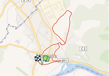
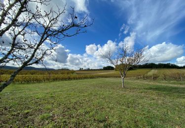
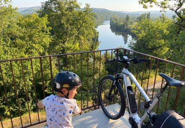
Randonnée Marche de 4,2 km à découvrir à Occitanie, Lot, Mercuès. Cette randonnée est proposée par Marc51.
Description
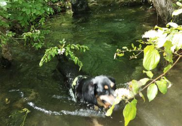
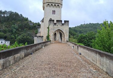
Chemin bétonné derrière la boulangerie. Passer par le vieux bourg puis traverser le petit pont du chemin de fer. Au carrefour à G direction Le Boudou. Avant la côte, ds le virage prendre à D, à 140m arrivée chez les Lacoux.
Localisation
Pays :
France
Région :
Occitanie
Département/Province :
Lot
Commune :
Mercuès
Localité :
Unknown
Départ:(Dec)
Départ:(UTM)
371649 ; 4928080 (31T) N.
Commentaires
Randonnées à proximité
![Randonnée Marche Maxou - Bois des Carrières_Le Lac-Blanc 5 km - Photo](https://media.geolcdn.com/t/375/260/8bbf484f-6401-4dee-85f0-ba90d0057aed.jpg&format=jpg&maxdim=2)
![Marche Marche](https://static1.geolcdn.com/sitytour/trail-icons/101.png)
Bois des Carrières_Le Lac-Blanc 5 km
Marche
Très facile
(1)
Maxou,
Occitanie,
Lot,
France
![](/images/other/stat-length.png)
5 km | 7,2 km-effort
2h 26min
![](https://static1.geolcdn.com/siteimages/upload/files/16400158638029165_repeat_loop_refresh_sync_direction_icon.png)
Oui
![Randonnée Marche nordique Pradines - 15km chemin des combettes - Photo](https://media.geolcdn.com/t/375/260/ext.jpg?maxdim=2&url=https%3A%2F%2Fstatic1.geolcdn.com%2Fsiteimages%2Fupload%2Ffiles%2F1545311037marcheuse_200dpi.jpg)
![Marche nordique Marche nordique](https://static1.geolcdn.com/sitytour/trail-icons/102.png)
15km chemin des combettes
Marche nordique
Très facile
(1)
Pradines,
Occitanie,
Lot,
France
![](/images/other/stat-length.png)
14,8 km | 17,9 km-effort
2h 15min
![](https://static1.geolcdn.com/siteimages/upload/files/16400158638029165_repeat_loop_refresh_sync_direction_icon.png)
Oui
![Randonnée Marche Crayssac - Crayssac Cévennes - Photo](https://media.geolcdn.com/t/375/260/f07bb3de-4c60-4431-b846-5572eb8ab419.jpg&format=jpg&maxdim=2)
![Marche Marche](https://static1.geolcdn.com/sitytour/trail-icons/101.png)
Crayssac Cévennes
Marche
Très facile
Crayssac,
Occitanie,
Lot,
France
![](/images/other/stat-length.png)
6,3 km | 9,1 km-effort
1h 43min
![](https://static1.geolcdn.com/siteimages/upload/files/16400158638029165_repeat_loop_refresh_sync_direction_icon.png)
Non
![Randonnée Marche Douelle - filles mamu aprem - Photo](https://media.geolcdn.com/t/375/260/cd9f458e-fb02-4c6e-9e6c-71d98e747b7b.jpg&format=jpg&maxdim=2)
![Marche Marche](https://static1.geolcdn.com/sitytour/trail-icons/101.png)
filles mamu aprem
Marche
Difficile
Douelle,
Occitanie,
Lot,
France
![](/images/other/stat-length.png)
11,4 km | 14,2 km-effort
3h 8min
![](https://static1.geolcdn.com/siteimages/upload/files/16400158638029165_repeat_loop_refresh_sync_direction_icon.png)
Non
![Randonnée Marche Trespoux-Rassiels - filles de manu 1juin24 - Photo](https://media.geolcdn.com/t/375/260/84f78169-4643-4282-b205-725e3a25e151.jpg&format=jpg&maxdim=2)
![Marche Marche](https://static1.geolcdn.com/sitytour/trail-icons/101.png)
filles de manu 1juin24
Marche
Moyen
Trespoux-Rassiels,
Occitanie,
Lot,
France
![](/images/other/stat-length.png)
5 km | 7,2 km-effort
1h 33min
![](https://static1.geolcdn.com/siteimages/upload/files/16400158638029165_repeat_loop_refresh_sync_direction_icon.png)
Oui
![Randonnée Marche Calamane - Calamane - Photo](https://media.geolcdn.com/t/375/260/be5d8ed0-6112-42c8-af8e-0a2b77a0b4c1.jpg&format=jpg&maxdim=2)
![Marche Marche](https://static1.geolcdn.com/sitytour/trail-icons/101.png)
![Randonnée Marche Mercuès - Mercues Caillac - Photo](https://media.geolcdn.com/t/375/260/1ad3e3bc-7774-41ec-b189-3cbf1574600e.jpg&format=jpg&maxdim=2)
![Marche Marche](https://static1.geolcdn.com/sitytour/trail-icons/101.png)
Mercues Caillac
Marche
Très facile
Mercuès,
Occitanie,
Lot,
France
![](/images/other/stat-length.png)
8,1 km | 9,7 km-effort
1h 59min
![](https://static1.geolcdn.com/siteimages/upload/files/16400158638029165_repeat_loop_refresh_sync_direction_icon.png)
Oui
![Randonnée V.T.C. Mercuès - Voie verte Mercues - Photo](https://media.geolcdn.com/t/375/260/546fc6c2-3dc2-41b1-ae90-8484728f06b7.jpg&format=jpg&maxdim=2)
![V.T.C. V.T.C.](https://static1.geolcdn.com/sitytour/trail-icons/203.png)
Voie verte Mercues
V.T.C.
Très facile
Mercuès,
Occitanie,
Lot,
France
![](/images/other/stat-length.png)
10,9 km | 12,7 km-effort
1h 57min
![](https://static1.geolcdn.com/siteimages/upload/files/16400158638029165_repeat_loop_refresh_sync_direction_icon.png)
Oui
![Randonnée Marche Cahors - cahors lascabanne durand - Photo](https://media.geolcdn.com/t/375/260/756321c4-2c9f-40a3-89e0-ac980ed918b3.jpg&format=jpg&maxdim=2)
![Marche Marche](https://static1.geolcdn.com/sitytour/trail-icons/101.png)
cahors lascabanne durand
Marche
Moyen
Cahors,
Occitanie,
Lot,
France
![](/images/other/stat-length.png)
24 km | 30 km-effort
6h 32min
![](https://static1.geolcdn.com/siteimages/upload/files/16400158638029165_repeat_loop_refresh_sync_direction_icon.png)
Non