![](/images/other/stat-length.png)
![Randonnée V.T.T. Saint-Paul-Trois-Châteaux - VTT_13R_Le Val des Nymphes - Photo](https://media.geolcdn.com/t/1900/400/ext.pjpeg?maxdim=2&url=https%3A%2F%2Fstatic1.geolcdn.com%2Fsiteimages%2Fupload%2Ffiles%2F1524743154velo.jpg)
VTT_13R_Le Val des Nymphes
charlytan
Utilisateur
![Longueur](/images/other/stat-length.png)
![Altitude max](https://static1.geolcdn.com/siteimages/upload/files/1508320355ic_sort_altitude_max_24dp.png)
![Dénivelé positif](https://static1.geolcdn.com/siteimages/upload/files/1508320355ic_sort_den_pos_24dp.png)
![Km-Effort](/images/other/stat-length.png)
![Altitude min](https://static1.geolcdn.com/siteimages/upload/files/1508320355ic_sort_altitude_min_24dp.png)
![Dénivelé négatif](https://static1.geolcdn.com/siteimages/upload/files/1508320355ic_sort_den_neg_24dp.png)
![Boucle](https://static1.geolcdn.com/siteimages/upload/files/16400158638029165_repeat_loop_refresh_sync_direction_icon.png)
![V.T.T.](https://static1.geolcdn.com/sitytour/trail-icons/202.png)
2h42
Difficulté : Difficile
![Scannez ce code QR pour ouvrir la randonnée dans l'application SityTrail](https://capi.geolives.com/qq0zvz2zws4bq2lad0pu/sitytour/trails/2906243/qr.png?size=200)
Application GPS de randonnée GRATUITE
À propos
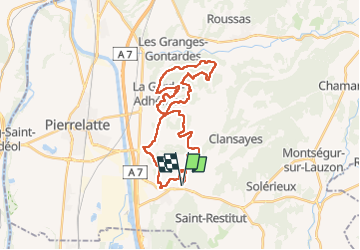
Randonnée V.T.T. de 33 km à découvrir à Auvergne-Rhône-Alpes, Drôme, Saint-Paul-Trois-Châteaux. Cette randonnée est proposée par charlytan.
Description
https://cyclotourisme26.org/base-vtt-tricastin-rouge-13/
Avec de beaux monotraces et de magnifiques points de vue, vous prendrez de la hauteur au village de la Garde-Adhémar. Une visite s’impose au lieu mystérieux du Val des Nymphes. Vous passerez près des caves lapidaires. Au retour, vous emprunterez de beaux sentiers au bord des vignes et vous traverserez la rivières.
Localisation
Commentaires
Randonnées à proximité
![Randonnée Marche Clansayes - Clansayes Le Rouvergue 7km - Photo](https://media.geolcdn.com/t/375/260/de3feb6f-5587-4e87-a580-1261cf3df48e.jpg&format=jpg&maxdim=2)
![Marche Marche](https://static1.geolcdn.com/sitytour/trail-icons/101.png)
Marche
![](/images/other/stat-length.png)
![](https://static1.geolcdn.com/siteimages/upload/files/16400158638029165_repeat_loop_refresh_sync_direction_icon.png)
![Randonnée Marche Saint-Restitut - St Restitut Le Barry 12km - Photo](https://media.geolcdn.com/t/375/260/52d96bcf-650b-4fd0-a59a-69f2b2d3703d.jpg&format=jpg&maxdim=2)
![Marche Marche](https://static1.geolcdn.com/sitytour/trail-icons/101.png)
Marche
![](/images/other/stat-length.png)
![](https://static1.geolcdn.com/siteimages/upload/files/16400158638029165_repeat_loop_refresh_sync_direction_icon.png)
![Randonnée Marche Bollène - Barry Chabrières Enclume 7,5km - Photo](https://media.geolcdn.com/t/375/260/3a4e67d1-088f-449d-b525-af6a45f2f0d7.jpg&format=jpg&maxdim=2)
![Marche Marche](https://static1.geolcdn.com/sitytour/trail-icons/101.png)
Marche
![](/images/other/stat-length.png)
![](https://static1.geolcdn.com/siteimages/upload/files/16400158638029165_repeat_loop_refresh_sync_direction_icon.png)
![Randonnée Marche Saint-Restitut - St Restitut Barry 14km - Photo](https://media.geolcdn.com/t/375/260/919620e4-c2f5-475b-864c-8c28884f4028.jpg&format=jpg&maxdim=2)
![Marche Marche](https://static1.geolcdn.com/sitytour/trail-icons/101.png)
Marche
![](/images/other/stat-length.png)
![](https://static1.geolcdn.com/siteimages/upload/files/16400158638029165_repeat_loop_refresh_sync_direction_icon.png)
![Randonnée Marche Saint-Restitut - Les carrières de Sainte Juste - Saint Restitut - Photo](https://media.geolcdn.com/t/375/260/ext.jpg?maxdim=2&url=https%3A%2F%2Fservices.sitytrail.com%2FGeolivesWS%2FDownloadMedia.ashx%3FTrailID%3D317462%26Media%3D16693_6.jpg)
![Marche Marche](https://static1.geolcdn.com/sitytour/trail-icons/101.png)
Marche
![](/images/other/stat-length.png)
![](https://static1.geolcdn.com/siteimages/upload/files/16400158638029165_repeat_loop_refresh_sync_direction_icon.png)
![Randonnée Marche Suze-la-Rousse - soleirieu - Photo](https://media.geolcdn.com/t/375/260/ext.jpg?maxdim=2&url=https%3A%2F%2Fstatic1.geolcdn.com%2Fsiteimages%2Fupload%2Ffiles%2F1553511878bg_sport_marche.png)
![Marche Marche](https://static1.geolcdn.com/sitytour/trail-icons/101.png)
Marche
![](/images/other/stat-length.png)
![](https://static1.geolcdn.com/siteimages/upload/files/16400158638029165_repeat_loop_refresh_sync_direction_icon.png)
![Randonnée Marche Clansayes - Clansayes Le Rouvergue 11km - Photo](https://media.geolcdn.com/t/375/260/89c952dc-9c57-4311-93c9-63263f0349ef.jpg&format=jpg&maxdim=2)
![Marche Marche](https://static1.geolcdn.com/sitytour/trail-icons/101.png)
Marche
![](/images/other/stat-length.png)
![](https://static1.geolcdn.com/siteimages/upload/files/16400158638029165_repeat_loop_refresh_sync_direction_icon.png)
![Randonnée Marche Clansayes - Clansayes Le Rouvergue 8km. - Photo](https://media.geolcdn.com/t/375/260/00183d4b-7799-462e-b9b9-5e3d9f7cb776.jpg&format=jpg&maxdim=2)
![Marche Marche](https://static1.geolcdn.com/sitytour/trail-icons/101.png)
Marche
![](/images/other/stat-length.png)
![](https://static1.geolcdn.com/siteimages/upload/files/16400158638029165_repeat_loop_refresh_sync_direction_icon.png)
![Randonnée Marche Clansayes - Clansayes Le Rouvergue 12km - Photo](https://media.geolcdn.com/t/375/260/10944c4f-f60a-41d6-ab1f-e2a3431a6612.jpg&format=jpg&maxdim=2)
![Marche Marche](https://static1.geolcdn.com/sitytour/trail-icons/101.png)
Marche
![](/images/other/stat-length.png)
![](https://static1.geolcdn.com/siteimages/upload/files/16400158638029165_repeat_loop_refresh_sync_direction_icon.png)