![](/images/other/stat-length.png)
![Randonnée Marche Les Junies - PC27---AUTOUR-DE-LA-VALLEE-DE-LA-MASSE-les-junies - Photo](https://media.geolcdn.com/t/1900/400/fad83b92-954b-44e0-9018-161ac3ae854f.jpg&format=pjpeg&maxdim=2)
PC27---AUTOUR-DE-LA-VALLEE-DE-LA-MASSE-les-junies
alain2306
Utilisateur
![Longueur](/images/other/stat-length.png)
![Altitude max](https://static1.geolcdn.com/siteimages/upload/files/1508320355ic_sort_altitude_max_24dp.png)
![Dénivelé positif](https://static1.geolcdn.com/siteimages/upload/files/1508320355ic_sort_den_pos_24dp.png)
![Km-Effort](/images/other/stat-length.png)
![Altitude min](https://static1.geolcdn.com/siteimages/upload/files/1508320355ic_sort_altitude_min_24dp.png)
![Dénivelé négatif](https://static1.geolcdn.com/siteimages/upload/files/1508320355ic_sort_den_neg_24dp.png)
![Boucle](https://static1.geolcdn.com/siteimages/upload/files/16400158638029165_repeat_loop_refresh_sync_direction_icon.png)
![Marche](https://static1.geolcdn.com/sitytour/trail-icons/101.png)
3h53
Difficulté : Difficile
![Scannez ce code QR pour ouvrir la randonnée dans l'application SityTrail](https://capi.geolives.com/qq0zvz2zws4bq2lad0pu/sitytour/trails/2899944/qr.png?size=200)
Application GPS de randonnée GRATUITE
À propos
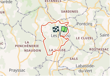
Randonnée Marche de 12 km à découvrir à Occitanie, Lot, Les Junies. Cette randonnée est proposée par alain2306.
Description
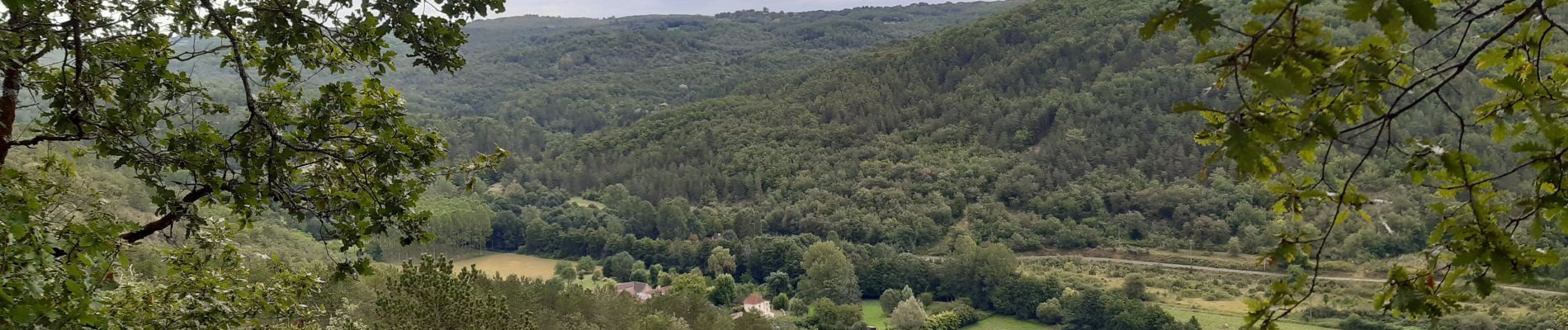
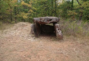
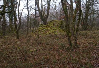
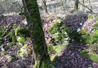
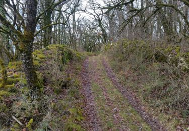
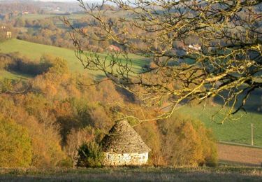
Découverte singulière et bucolique de la vallée de la Masse, son église aux peintures murales remarquables, ses petits hameaux, ses menhirs et ses dolmens.
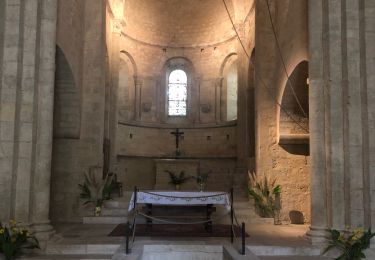
Construite au XIIe siècle, l’église de La Masse, remarquable par son imposant clocher-mur, abrite d’étonnantes peintures murales datées de la fin du Moyen-âge. Sur les parois de la nef, un ou plusieurs artistes anonymes ont figuré les sept péchés capitaux sous la forme d’un défilé de personnages guidés par des démons. L’orgueil est figuré par un noble monté sur un lion et tenant un faucon à la main, l’avarice par un homme portant trois bourses que l’on imagine pleines d’or.
- Circuit accessible aux VTT.
- Difficultés particulières : Attention certains passages escarpés.
Localisation
Commentaires
Randonnées à proximité
![Randonnée Marche Montgesty - Montgesty - Photo](https://media.geolcdn.com/t/375/260/ba0aa058-b6ad-4004-8313-7b5a08a3e041.jpg&format=jpg&maxdim=2)
![Marche Marche](https://static1.geolcdn.com/sitytour/trail-icons/101.png)
![Randonnée Marche Les Junies - les junies - Photo](https://media.geolcdn.com/t/375/260/76d02f5a-fbe7-4ae2-9039-75af13e1e019.jpg&format=jpg&maxdim=2)
![Marche Marche](https://static1.geolcdn.com/sitytour/trail-icons/101.png)
![Randonnée Marche Luzech - Fages_Pech-vert_Foulquet 6,5 - Photo](https://media.geolcdn.com/t/375/260/338f1118-5eea-4e57-9527-5664443760c4.jpg&format=jpg&maxdim=2)
![Marche Marche](https://static1.geolcdn.com/sitytour/trail-icons/101.png)
Marche
![](/images/other/stat-length.png)
![](https://static1.geolcdn.com/siteimages/upload/files/16400158638029165_repeat_loop_refresh_sync_direction_icon.png)
![Randonnée Marche Castelfranc - Castelfranc Tindout 2019 02 08 - Photo](https://media.geolcdn.com/t/375/260/e80082af-b8d1-43d9-93e0-f745cfe9929d.jpg&format=jpg&maxdim=2)
![Marche Marche](https://static1.geolcdn.com/sitytour/trail-icons/101.png)
Marche
![](/images/other/stat-length.png)
![](https://static1.geolcdn.com/siteimages/upload/files/16400158638029165_repeat_loop_refresh_sync_direction_icon.png)
![Randonnée Marche Castelfranc - Castelfranc Tindout photos - Photo](https://media.geolcdn.com/t/375/260/efe0a7fb-1925-40d4-8fb0-59e40660d7aa.jpg&format=jpg&maxdim=2)
![Marche Marche](https://static1.geolcdn.com/sitytour/trail-icons/101.png)
Marche
![](/images/other/stat-length.png)
![](https://static1.geolcdn.com/siteimages/upload/files/16400158638029165_repeat_loop_refresh_sync_direction_icon.png)
![Randonnée Marche Montgesty - Montgesty - Photo](https://media.geolcdn.com/t/375/260/ext.jpg?maxdim=2&url=https%3A%2F%2Fservices.sitytrail.com%2FGeolivesWS%2FDownloadMedia.ashx%3FTrailID%3D101247%26Media%3D735_1.jpg)
![Marche Marche](https://static1.geolcdn.com/sitytour/trail-icons/101.png)
![Randonnée sport Saint-Médard - Raynal - Photo](https://media.geolcdn.com/t/375/260/ext.jpg?maxdim=2&url=https%3A%2F%2Fsecurestorage.geolives.com%2Fsitytour%2Ftrail-bg%2Fdefault.jpg)
![Randonnée Marche Les Junies - les junies - Photo](https://media.geolcdn.com/t/375/260/ext.jpg?maxdim=2&url=https%3A%2F%2Fstatic1.geolcdn.com%2Fsiteimages%2Fupload%2Ffiles%2F1553511878bg_sport_marche.png)
![Marche Marche](https://static1.geolcdn.com/sitytour/trail-icons/101.png)
Marche
![](/images/other/stat-length.png)
![](https://static1.geolcdn.com/siteimages/upload/files/16400158638029165_repeat_loop_refresh_sync_direction_icon.png)
![Randonnée Vélo de route Pontcirq - La balade du CLUZEL - Photo](https://media.geolcdn.com/t/375/260/2c353918-da96-41c9-99fe-2ff9630ad0f0.jpg&format=jpg&maxdim=2)
![Vélo de route Vélo de route](https://static1.geolcdn.com/sitytour/trail-icons/201.png)
Vélo de route
![](/images/other/stat-length.png)
![](https://static1.geolcdn.com/siteimages/upload/files/16400158638029165_repeat_loop_refresh_sync_direction_icon.png)
beaux chemins et paysages, trop de bitumes cependant.