![](/images/other/stat-length.png)
![Randonnée Marche Gorinchem - Randonnée Gorinchem > Hardinxveld-Giessendam - Photo](https://media.geolcdn.com/t/1900/400/ext.pjpeg?maxdim=2&url=https%3A%2F%2Fstatic1.geolcdn.com%2Fsiteimages%2Fupload%2Ffiles%2F1553511878bg_sport_marche.png)
Randonnée Gorinchem > Hardinxveld-Giessendam
pegpeg
Utilisateur
![Longueur](/images/other/stat-length.png)
Longueur
12,2 km
![Altitude max](https://static1.geolcdn.com/siteimages/upload/files/1508320355ic_sort_altitude_max_24dp.png)
Altitude max
6 m
![Dénivelé positif](https://static1.geolcdn.com/siteimages/upload/files/1508320355ic_sort_den_pos_24dp.png)
Dénivelé positif
41 m
![Km-Effort](/images/other/stat-length.png)
Km-Effort
12,8 km
![Altitude min](https://static1.geolcdn.com/siteimages/upload/files/1508320355ic_sort_altitude_min_24dp.png)
Altitude min
-4 m
![Dénivelé négatif](https://static1.geolcdn.com/siteimages/upload/files/1508320355ic_sort_den_neg_24dp.png)
Dénivelé négatif
42 m
![Boucle](https://static1.geolcdn.com/siteimages/upload/files/16400158638029165_repeat_loop_refresh_sync_direction_icon.png)
Boucle
Non
Date de création :
2021-08-15 08:48:42.278
Dernière modification :
2021-08-16 10:28:01.327
![Marche](https://static1.geolcdn.com/sitytour/trail-icons/101.png)
2h30
Difficulté : Facile
![Scannez ce code QR pour ouvrir la randonnée dans l'application SityTrail](https://capi.geolives.com/qq0zvz2zws4bq2lad0pu/sitytour/trails/2899221/qr.png?size=200)
Application GPS de randonnée GRATUITE
À propos
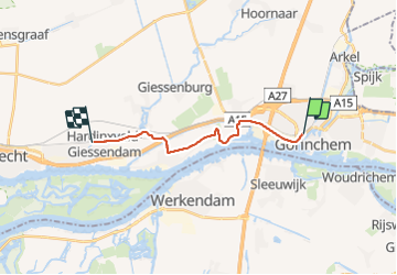
Randonnée Marche de 12,2 km à découvrir à Hollande-Méridionale, Inconnu, Gorinchem. Cette randonnée est proposée par pegpeg.
Description
Jolie randonnée dans la nature autour de Rotterdam de la gare de Hardinxveld-Giessendam à la gare de Gorinchem. Le train passe par Dordrecht, une très jolie ville où on peut s'arrêter.
Localisation
Pays :
Pays-Bas
Région :
Hollande-Méridionale
Département/Province :
Inconnu
Commune :
Gorinchem
Localité :
Unknown
Départ:(Dec)
Départ:(UTM)
635560 ; 5744379 (31U) N.
Commentaires
Randonnées à proximité
![Randonnée Moteur Molenlanden - a-utrecht-arkel-linge-route-via-buren-en-terug - Photo](https://media.geolcdn.com/t/375/260/ext.jpg?maxdim=2&url=https%3A%2F%2Fstatic1.geolcdn.com%2Fsiteimages%2Fupload%2Ffiles%2F15247431544x4.jpg)
![Moteur Moteur](https://static1.geolcdn.com/sitytour/trail-icons/400.png)
a-utrecht-arkel-linge-route-via-buren-en-terug
Moteur
Très facile
Molenlanden,
Hollande-Méridionale,
Inconnu,
Pays-Bas
![](/images/other/stat-length.png)
71 km | 74 km-effort
Inconnu
![](https://static1.geolcdn.com/siteimages/upload/files/16400158638029165_repeat_loop_refresh_sync_direction_icon.png)
Non
![Randonnée Moteur Altena - a-nbrabant-hyperpro-rondrit - Photo](https://media.geolcdn.com/t/375/260/ext.jpg?maxdim=2&url=https%3A%2F%2Fstatic1.geolcdn.com%2Fsiteimages%2Fupload%2Ffiles%2F15247431544x4.jpg)
![Moteur Moteur](https://static1.geolcdn.com/sitytour/trail-icons/400.png)
a-nbrabant-hyperpro-rondrit
Moteur
Très facile
Altena,
Brabant-Septentrional,
Inconnu,
Pays-Bas
![](/images/other/stat-length.png)
231 km | 245 km-effort
Inconnu
![](https://static1.geolcdn.com/siteimages/upload/files/16400158638029165_repeat_loop_refresh_sync_direction_icon.png)
Oui
![Randonnée Moteur Molenlanden - a-nbrabant-anwb-lek-en-linge - Photo](https://media.geolcdn.com/t/375/260/ext.jpg?maxdim=2&url=https%3A%2F%2Fstatic1.geolcdn.com%2Fsiteimages%2Fupload%2Ffiles%2F15247431544x4.jpg)
![Moteur Moteur](https://static1.geolcdn.com/sitytour/trail-icons/400.png)
a-nbrabant-anwb-lek-en-linge
Moteur
Très facile
Molenlanden,
Hollande-Méridionale,
Inconnu,
Pays-Bas
![](/images/other/stat-length.png)
85 km | 88 km-effort
Inconnu
![](https://static1.geolcdn.com/siteimages/upload/files/16400158638029165_repeat_loop_refresh_sync_direction_icon.png)
Oui
![Randonnée Vélo Altena - Noord-Brabant - Rondom afgedamde Maas - Photo](https://media.geolcdn.com/t/375/260/ext.jpg?maxdim=2&url=https%3A%2F%2Fstatic1.geolcdn.com%2Fsiteimages%2Fupload%2Ffiles%2F1524743154velo.jpg)
![Vélo Vélo](https://static1.geolcdn.com/sitytour/trail-icons/200.png)
Noord-Brabant - Rondom afgedamde Maas
Vélo
Très facile
Altena,
Brabant-Septentrional,
Inconnu,
Pays-Bas
![](/images/other/stat-length.png)
32 km | 34 km-effort
Inconnu
![](https://static1.geolcdn.com/siteimages/upload/files/16400158638029165_repeat_loop_refresh_sync_direction_icon.png)
Oui
![Randonnée Vélo Altena - f-nbrabant-altena-triangel - Photo](https://media.geolcdn.com/t/375/260/ext.jpg?maxdim=2&url=https%3A%2F%2Fstatic1.geolcdn.com%2Fsiteimages%2Fupload%2Ffiles%2F1524743154velo.jpg)
![Vélo Vélo](https://static1.geolcdn.com/sitytour/trail-icons/200.png)
f-nbrabant-altena-triangel
Vélo
Très facile
Altena,
Brabant-Septentrional,
Inconnu,
Pays-Bas
![](/images/other/stat-length.png)
27 km | 28 km-effort
Inconnu
![](https://static1.geolcdn.com/siteimages/upload/files/16400158638029165_repeat_loop_refresh_sync_direction_icon.png)
Oui
![Randonnée Vélo Altena - f-nbrabant-altena-biesbosch-ronde - Photo](https://media.geolcdn.com/t/375/260/ext.jpg?maxdim=2&url=https%3A%2F%2Fstatic1.geolcdn.com%2Fsiteimages%2Fupload%2Ffiles%2F1524743154velo.jpg)
![Vélo Vélo](https://static1.geolcdn.com/sitytour/trail-icons/200.png)
f-nbrabant-altena-biesbosch-ronde
Vélo
Très facile
Altena,
Brabant-Septentrional,
Inconnu,
Pays-Bas
![](/images/other/stat-length.png)
160 km | 165 km-effort
Inconnu
![](https://static1.geolcdn.com/siteimages/upload/files/16400158638029165_repeat_loop_refresh_sync_direction_icon.png)
Non
![Randonnée Marche Gorinchem - w-zholland-ns-wandeling-fort-vuren - Photo](https://media.geolcdn.com/t/375/260/ext.jpg?maxdim=2&url=https%3A%2F%2Fstatic1.geolcdn.com%2Fsiteimages%2Fupload%2Ffiles%2F1553511878bg_sport_marche.png)
![Marche Marche](https://static1.geolcdn.com/sitytour/trail-icons/101.png)
w-zholland-ns-wandeling-fort-vuren
Marche
Très facile
Gorinchem,
Hollande-Méridionale,
Inconnu,
Pays-Bas
![](/images/other/stat-length.png)
24 km | 25 km-effort
Inconnu
![](https://static1.geolcdn.com/siteimages/upload/files/16400158638029165_repeat_loop_refresh_sync_direction_icon.png)
Non
![Randonnée Marche Gorinchem - w-zholland-gornichem-naar-leerdam-waterliniepad - Photo](https://media.geolcdn.com/t/375/260/ext.jpg?maxdim=2&url=https%3A%2F%2Fstatic1.geolcdn.com%2Fsiteimages%2Fupload%2Ffiles%2F1553511878bg_sport_marche.png)
![Marche Marche](https://static1.geolcdn.com/sitytour/trail-icons/101.png)
w-zholland-gornichem-naar-leerdam-waterliniepad
Marche
Très facile
Gorinchem,
Hollande-Méridionale,
Inconnu,
Pays-Bas
![](/images/other/stat-length.png)
23 km | 24 km-effort
Inconnu
![](https://static1.geolcdn.com/siteimages/upload/files/16400158638029165_repeat_loop_refresh_sync_direction_icon.png)
Non
![Randonnée Marche Altena - w-nbrabant-oostwaardpad - Photo](https://media.geolcdn.com/t/375/260/ext.jpg?maxdim=2&url=https%3A%2F%2Fstatic1.geolcdn.com%2Fsiteimages%2Fupload%2Ffiles%2F1553511878bg_sport_marche.png)
![Marche Marche](https://static1.geolcdn.com/sitytour/trail-icons/101.png)
w-nbrabant-oostwaardpad
Marche
Très facile
Altena,
Brabant-Septentrional,
Inconnu,
Pays-Bas
![](/images/other/stat-length.png)
21 km | 22 km-effort
Inconnu
![](https://static1.geolcdn.com/siteimages/upload/files/16400158638029165_repeat_loop_refresh_sync_direction_icon.png)
Oui