![](/images/other/stat-length.png)
![Randonnée Course à pied Lit-et-Mixe - Cross depuis le camping](https://media.geolcdn.com/t/1900/400/ext.pjpeg?maxdim=2&url=https%3A%2F%2Fstatic1.geolcdn.com%2Fsiteimages%2Fupload%2Ffiles%2F1524743154running.jpg)
Cross depuis le camping "Le Soleil des Landes"
Alokteff
Utilisateur
![Longueur](/images/other/stat-length.png)
Longueur
8,4 km
![Altitude max](https://static1.geolcdn.com/siteimages/upload/files/1508320355ic_sort_altitude_max_24dp.png)
Altitude max
42 m
![Dénivelé positif](https://static1.geolcdn.com/siteimages/upload/files/1508320355ic_sort_den_pos_24dp.png)
Dénivelé positif
99 m
![Km-Effort](/images/other/stat-length.png)
Km-Effort
9,7 km
![Altitude min](https://static1.geolcdn.com/siteimages/upload/files/1508320355ic_sort_altitude_min_24dp.png)
Altitude min
11 m
![Dénivelé négatif](https://static1.geolcdn.com/siteimages/upload/files/1508320355ic_sort_den_neg_24dp.png)
Dénivelé négatif
100 m
![Boucle](https://static1.geolcdn.com/siteimages/upload/files/16400158638029165_repeat_loop_refresh_sync_direction_icon.png)
Boucle
Oui
Date de création :
2021-08-15 05:03:15.359
Dernière modification :
2021-08-15 07:05:10.096
![Course à pied](https://static1.geolcdn.com/sitytour/trail-icons/103.png)
1h19
Difficulté : Facile
![Scannez ce code QR pour ouvrir la randonnée dans l'application SityTrail](https://capi.geolives.com/qq0zvz2zws4bq2lad0pu/sitytour/trails/2898574/qr.png?size=200)
Application GPS de randonnée GRATUITE
À propos
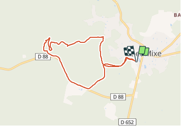
Randonnée Course à pied de 8,4 km à découvrir à Nouvelle-Aquitaine, Landes, Lit-et-Mixe. Cette randonnée est proposée par Alokteff.
Description
Au départ du camping, piste cyclable jusqu'au parcours santé, retour à travers la pinède jusqu'au camping
Localisation
Pays :
France
Région :
Nouvelle-Aquitaine
Département/Province :
Landes
Commune :
Lit-et-Mixe
Localité :
Unknown
Départ:(Dec)
Départ:(UTM)
639517 ; 4876677 (30T) N.
Commentaires
Randonnées à proximité
![Randonnée Marche Lit-et-Mixe - étape 3 Compostelle 24 - Photo](https://media.geolcdn.com/t/375/260/ext.jpg?maxdim=2&url=https%3A%2F%2Fmedia.geolcdn.com%2Ff%2F6c540f96-f272-4668-af92-421fff830c7c.jpg)
![Marche Marche](https://static1.geolcdn.com/sitytour/trail-icons/101.png)
étape 3 Compostelle 24
Marche
Difficile
Lit-et-Mixe,
Nouvelle-Aquitaine,
Landes,
France
![](/images/other/stat-length.png)
14,5 km | 16,1 km-effort
6h 56min
![](https://static1.geolcdn.com/siteimages/upload/files/16400158638029165_repeat_loop_refresh_sync_direction_icon.png)
Non
![Randonnée Marche Saint-Julien-en-Born - St Julien en Born - Photo](https://media.geolcdn.com/t/375/260/ext.jpg?maxdim=2&url=https%3A%2F%2Fservices.sitytrail.com%2FGeolivesWS%2FDownloadMedia.ashx%3FTrailID%3D340801%26Media%3Dfix__20140831131521.jpg)
![Marche Marche](https://static1.geolcdn.com/sitytour/trail-icons/101.png)
St Julien en Born
Marche
Facile
Saint-Julien-en-Born,
Nouvelle-Aquitaine,
Landes,
France
![](/images/other/stat-length.png)
7 km | 7,7 km-effort
1h 42min
![](https://static1.geolcdn.com/siteimages/upload/files/16400158638029165_repeat_loop_refresh_sync_direction_icon.png)
Oui
![Randonnée Cyclotourisme Lit-et-Mixe - Léon - Les pistes sous les pins - Photo](https://media.geolcdn.com/t/375/260/ext.jpg?maxdim=2&url=https%3A%2F%2Fstatic1.geolcdn.com%2Fsiteimages%2Fupload%2Ffiles%2F1524743154velo.jpg)
![Cyclotourisme Cyclotourisme](https://static1.geolcdn.com/sitytour/trail-icons/204.png)
Léon - Les pistes sous les pins
Cyclotourisme
Moyen
Lit-et-Mixe,
Nouvelle-Aquitaine,
Landes,
France
![](/images/other/stat-length.png)
73 km | 84 km-effort
Inconnu
![](https://static1.geolcdn.com/siteimages/upload/files/16400158638029165_repeat_loop_refresh_sync_direction_icon.png)
Oui
![Randonnée Marche Lit-et-Mixe - Compostelle 24 étape 3 lit et mixe St Giron - Photo](https://media.geolcdn.com/t/375/260/ext.jpg?maxdim=2&url=https%3A%2F%2Fstatic1.geolcdn.com%2Fsiteimages%2Fupload%2Ffiles%2F1553511878bg_sport_marche.png)
![Marche Marche](https://static1.geolcdn.com/sitytour/trail-icons/101.png)
Compostelle 24 étape 3 lit et mixe St Giron
Marche
Difficile
Lit-et-Mixe,
Nouvelle-Aquitaine,
Landes,
France
![](/images/other/stat-length.png)
16,2 km | 18,1 km-effort
4h 7min
![](https://static1.geolcdn.com/siteimages/upload/files/16400158638029165_repeat_loop_refresh_sync_direction_icon.png)
Non
![Randonnée Course à pied Lit-et-Mixe - lit et mice - Photo](https://media.geolcdn.com/t/375/260/ext.jpg?maxdim=2&url=https%3A%2F%2Fstatic1.geolcdn.com%2Fsiteimages%2Fupload%2Ffiles%2F1524743154running.jpg)
![Course à pied Course à pied](https://static1.geolcdn.com/sitytour/trail-icons/103.png)
lit et mice
Course à pied
Très facile
Lit-et-Mixe,
Nouvelle-Aquitaine,
Landes,
France
![](/images/other/stat-length.png)
5,4 km | 6,1 km-effort
35min
![](https://static1.geolcdn.com/siteimages/upload/files/16400158638029165_repeat_loop_refresh_sync_direction_icon.png)
Oui
![Randonnée Marche Saint-Julien-en-Born - Comp 23 Étape 8 St julien en Born Vielle Saint Girons - Photo](https://media.geolcdn.com/t/375/260/ext.jpg?maxdim=2&url=https%3A%2F%2Fstatic1.geolcdn.com%2Fsiteimages%2Fupload%2Ffiles%2F1553511878bg_sport_marche.png)
![Marche Marche](https://static1.geolcdn.com/sitytour/trail-icons/101.png)
Comp 23 Étape 8 St julien en Born Vielle Saint Girons
Marche
Moyen
Saint-Julien-en-Born,
Nouvelle-Aquitaine,
Landes,
France
![](/images/other/stat-length.png)
19,9 km | 23 km-effort
5h 10min
![](https://static1.geolcdn.com/siteimages/upload/files/16400158638029165_repeat_loop_refresh_sync_direction_icon.png)
Non
![Randonnée V.T.T. Lit-et-Mixe - Plage déserte 2 - Photo](https://media.geolcdn.com/t/375/260/ext.jpg?maxdim=2&url=https%3A%2F%2Fstatic1.geolcdn.com%2Fsiteimages%2Fupload%2Ffiles%2F1524743154velo.jpg)
![V.T.T. V.T.T.](https://static1.geolcdn.com/sitytour/trail-icons/202.png)
Plage déserte 2
V.T.T.
Facile
Lit-et-Mixe,
Nouvelle-Aquitaine,
Landes,
France
![](/images/other/stat-length.png)
16 km | 18,7 km-effort
3h 57min
![](https://static1.geolcdn.com/siteimages/upload/files/16400158638029165_repeat_loop_refresh_sync_direction_icon.png)
Oui
![Randonnée Marche Saint-Julien-en-Born - La plaine du sable blanc - Photo](https://media.geolcdn.com/t/375/260/ext.jpg?maxdim=2&url=https%3A%2F%2Fstatic1.geolcdn.com%2Fsiteimages%2Fupload%2Ffiles%2F1553511878bg_sport_marche.png)
![Marche Marche](https://static1.geolcdn.com/sitytour/trail-icons/101.png)
La plaine du sable blanc
Marche
Saint-Julien-en-Born,
Nouvelle-Aquitaine,
Landes,
France
![](/images/other/stat-length.png)
7,2 km | 7,9 km-effort
2h 12min
![](https://static1.geolcdn.com/siteimages/upload/files/16400158638029165_repeat_loop_refresh_sync_direction_icon.png)
Oui