![](/images/other/stat-length.png)
![Randonnée V.T.T. Crévoux - Boucle du Réal - Photo](https://media.geolcdn.com/t/1900/400/ext.pjpeg?maxdim=2&url=https%3A%2F%2Fstatic1.geolcdn.com%2Fsiteimages%2Fupload%2Ffiles%2F1524743154velo.jpg)
Boucle du Réal
xaviergilles
Utilisateur
![Longueur](/images/other/stat-length.png)
Longueur
13,5 km
![Altitude max](https://static1.geolcdn.com/siteimages/upload/files/1508320355ic_sort_altitude_max_24dp.png)
Altitude max
1915 m
![Dénivelé positif](https://static1.geolcdn.com/siteimages/upload/files/1508320355ic_sort_den_pos_24dp.png)
Dénivelé positif
419 m
![Km-Effort](/images/other/stat-length.png)
Km-Effort
19,2 km
![Altitude min](https://static1.geolcdn.com/siteimages/upload/files/1508320355ic_sort_altitude_min_24dp.png)
Altitude min
1593 m
![Dénivelé négatif](https://static1.geolcdn.com/siteimages/upload/files/1508320355ic_sort_den_neg_24dp.png)
Dénivelé négatif
457 m
![Boucle](https://static1.geolcdn.com/siteimages/upload/files/16400158638029165_repeat_loop_refresh_sync_direction_icon.png)
Boucle
Non
Date de création :
2021-08-13 13:07:12.0
Dernière modification :
2021-08-13 15:30:38.838
![V.T.T.](https://static1.geolcdn.com/sitytour/trail-icons/202.png)
2h00
Difficulté : Facile
![Scannez ce code QR pour ouvrir la randonnée dans l'application SityTrail](https://capi.geolives.com/qq0zvz2zws4bq2lad0pu/sitytour/trails/2896773/qr.png?size=200)
Application GPS de randonnée GRATUITE
À propos
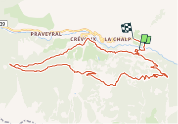
Randonnée V.T.T. de 13,5 km à découvrir à Provence-Alpes-Côte d'Azur, Hautes-Alpes, Crévoux. Cette randonnée est proposée par xaviergilles.
Description
Petite boucle dans mes bois de Crevoux. Très agréable, sans difficulté particulière. Quelques montées un petit peu pénibles de pour les plus petits mais courtes.
Localisation
Pays :
France
Région :
Provence-Alpes-Côte d'Azur
Département/Province :
Hautes-Alpes
Commune :
Crévoux
Localité :
Unknown
Départ:(Dec)
Départ:(UTM)
311515 ; 4935148 (32T) N.
Commentaires
Randonnées à proximité
![Randonnée Marche Crévoux - La Cascade de Razis - Photo](https://media.geolcdn.com/t/375/260/ext.jpg?maxdim=2&url=https%3A%2F%2Fservices.sitytrail.com%2FGeolivesWS%2FDownloadMedia.ashx%3FTrailID%3D109634%26Media%3D4275_1.jpg)
![Marche Marche](https://static1.geolcdn.com/sitytour/trail-icons/101.png)
La Cascade de Razis
Marche
Moyen
(5)
Crévoux,
Provence-Alpes-Côte d'Azur,
Hautes-Alpes,
France
![](/images/other/stat-length.png)
7,2 km | 11 km-effort
3h 30min
![](https://static1.geolcdn.com/siteimages/upload/files/16400158638029165_repeat_loop_refresh_sync_direction_icon.png)
Oui
![Randonnée Autre activité Crévoux - Ski. Sommet de Meale par Praveyral - Photo](https://media.geolcdn.com/t/375/260/ext.jpg?maxdim=2&url=https%3A%2F%2Fstatic1.geolcdn.com%2Fsiteimages%2Fupload%2Ffiles%2F1545311037marcheuse_200dpi.jpg)
![Autre activité Autre activité](https://static1.geolcdn.com/sitytour/trail-icons/900.png)
Ski. Sommet de Meale par Praveyral
Autre activité
Très facile
(6)
Crévoux,
Provence-Alpes-Côte d'Azur,
Hautes-Alpes,
France
![](/images/other/stat-length.png)
7,4 km | 16,7 km-effort
3h 20min
![](https://static1.geolcdn.com/siteimages/upload/files/16400158638029165_repeat_loop_refresh_sync_direction_icon.png)
Non
![Randonnée Marche Crévoux - Lac du Crachet (boucle) - Photo](https://media.geolcdn.com/t/375/260/ext.jpg?maxdim=2&url=https%3A%2F%2Fservices.sitytrail.com%2FGeolivesWS%2FDownloadMedia.ashx%3FTrailID%3D619371%26Media%3Dfix__20160821105233.jpg)
![Marche Marche](https://static1.geolcdn.com/sitytour/trail-icons/101.png)
Lac du Crachet (boucle)
Marche
Difficile
(1)
Crévoux,
Provence-Alpes-Côte d'Azur,
Hautes-Alpes,
France
![](/images/other/stat-length.png)
10,3 km | 21 km-effort
4h 50min
![](https://static1.geolcdn.com/siteimages/upload/files/16400158638029165_repeat_loop_refresh_sync_direction_icon.png)
Oui
![Randonnée Marche Crévoux - PARCOURS DES FEES #7 - Photo](https://media.geolcdn.com/t/375/260/ext.jpg?maxdim=2&url=https%3A%2F%2Fservices.sitytrail.com%2FGeolivesWS%2FDownloadMedia.ashx%3FTrailID%3D606320%26Media%3D812d22bb-a879-4b52-81d0-d1a210f7c536.JPG)
![Marche Marche](https://static1.geolcdn.com/sitytour/trail-icons/101.png)
PARCOURS DES FEES #7
Marche
Moyen
(1)
Crévoux,
Provence-Alpes-Côte d'Azur,
Hautes-Alpes,
France
![](/images/other/stat-length.png)
8,3 km | 11,6 km-effort
2h 35min
![](https://static1.geolcdn.com/siteimages/upload/files/16400158638029165_repeat_loop_refresh_sync_direction_icon.png)
Oui
![Randonnée Marche Les Orres - 2012-08-10_Sentier du garde - Photo](https://media.geolcdn.com/t/375/260/ext.jpg?maxdim=2&url=https%3A%2F%2Fservices.sitytrail.com%2FGeolivesWS%2FDownloadMedia.ashx%3FTrailID%3D145344%26Media%3D3eb37f19-c6a6-4c29-8161-da219dedd017.jpeg)
![Marche Marche](https://static1.geolcdn.com/sitytour/trail-icons/101.png)
2012-08-10_Sentier du garde
Marche
Moyen
(1)
Les Orres,
Provence-Alpes-Côte d'Azur,
Hautes-Alpes,
France
![](/images/other/stat-length.png)
11,3 km | 17,6 km-effort
4h 6min
![](https://static1.geolcdn.com/siteimages/upload/files/16400158638029165_repeat_loop_refresh_sync_direction_icon.png)
Oui
![Randonnée Marche Saint-André-d'Embrun - chalet de la biche . mont orel . chapelle de pra leydon . chalet de la coche - Photo](https://media.geolcdn.com/t/375/260/fc8a76ce-7e92-44f8-a3b6-e3a752334a37.jpg&format=jpg&maxdim=2)
![Marche Marche](https://static1.geolcdn.com/sitytour/trail-icons/101.png)
chalet de la biche . mont orel . chapelle de pra leydon . chalet de la coche
Marche
Difficile
Saint-André-d'Embrun,
Provence-Alpes-Côte d'Azur,
Hautes-Alpes,
France
![](/images/other/stat-length.png)
9,4 km | 21 km-effort
4h 59min
![](https://static1.geolcdn.com/siteimages/upload/files/16400158638029165_repeat_loop_refresh_sync_direction_icon.png)
Non
![Randonnée Marche Crévoux - Parcours des Fées - Crevoux - Photo](https://media.geolcdn.com/t/375/260/62d5f5b8-1ebc-4b09-a28c-b9abebde2749.jpg&format=jpg&maxdim=2)
![Marche Marche](https://static1.geolcdn.com/sitytour/trail-icons/101.png)
Parcours des Fées - Crevoux
Marche
Facile
Crévoux,
Provence-Alpes-Côte d'Azur,
Hautes-Alpes,
France
![](/images/other/stat-length.png)
6,1 km | 9 km-effort
1h 52min
![](https://static1.geolcdn.com/siteimages/upload/files/16400158638029165_repeat_loop_refresh_sync_direction_icon.png)
Oui
![Randonnée Marche Crévoux - Le lac du Crachet - Photo](https://media.geolcdn.com/t/375/260/ext.jpg?maxdim=2&url=https%3A%2F%2Fstatic1.geolcdn.com%2Fsiteimages%2Fupload%2Ffiles%2F1553511878bg_sport_marche.png)
![Marche Marche](https://static1.geolcdn.com/sitytour/trail-icons/101.png)
Le lac du Crachet
Marche
Très facile
(2)
Crévoux,
Provence-Alpes-Côte d'Azur,
Hautes-Alpes,
France
![](/images/other/stat-length.png)
3,6 km | 9,7 km-effort
2h 15min
![](https://static1.geolcdn.com/siteimages/upload/files/16400158638029165_repeat_loop_refresh_sync_direction_icon.png)
Non
![Randonnée Raquettes à neige Crévoux - EMBRUN JOUR 4 : Torrent du Crachet - Photo](https://media.geolcdn.com/t/375/260/3e9f82e9-86b1-4473-874d-37d7060460f8.jpg&format=jpg&maxdim=2)
![Raquettes à neige Raquettes à neige](https://static1.geolcdn.com/sitytour/trail-icons/504.png)
EMBRUN JOUR 4 : Torrent du Crachet
Raquettes à neige
Difficile
Crévoux,
Provence-Alpes-Côte d'Azur,
Hautes-Alpes,
France
![](/images/other/stat-length.png)
6,6 km | 12,8 km-effort
4h 13min
![](https://static1.geolcdn.com/siteimages/upload/files/16400158638029165_repeat_loop_refresh_sync_direction_icon.png)
Oui