![](/images/other/stat-length.png)
![Randonnée Marche Piesport - Piesport 17,5 km - Photo](https://media.geolcdn.com/t/1900/400/e62b9f6d-0440-419e-8c5e-60a3d0b10524.jpg&format=pjpeg&maxdim=2)
Piesport 17,5 km
rvapeldo
Utilisateur GUIDE
![Longueur](/images/other/stat-length.png)
![Altitude max](https://static1.geolcdn.com/siteimages/upload/files/1508320355ic_sort_altitude_max_24dp.png)
![Dénivelé positif](https://static1.geolcdn.com/siteimages/upload/files/1508320355ic_sort_den_pos_24dp.png)
![Km-Effort](/images/other/stat-length.png)
![Altitude min](https://static1.geolcdn.com/siteimages/upload/files/1508320355ic_sort_altitude_min_24dp.png)
![Dénivelé négatif](https://static1.geolcdn.com/siteimages/upload/files/1508320355ic_sort_den_neg_24dp.png)
![Boucle](https://static1.geolcdn.com/siteimages/upload/files/16400158638029165_repeat_loop_refresh_sync_direction_icon.png)
![Marche](https://static1.geolcdn.com/sitytour/trail-icons/101.png)
5h43
Difficulté : Moyen
![Scannez ce code QR pour ouvrir la randonnée dans l'application SityTrail](https://capi.geolives.com/qq0zvz2zws4bq2lad0pu/sitytour/trails/2896636/qr.png?size=200)
Application GPS de randonnée GRATUITE
À propos
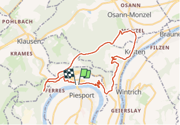
Randonnée Marche de 17,6 km à découvrir à Rhénanie-Palatinat, Landkreis Bernkastel-Wittlich, Piesport. Cette randonnée est proposée par rvapeldo.
Description
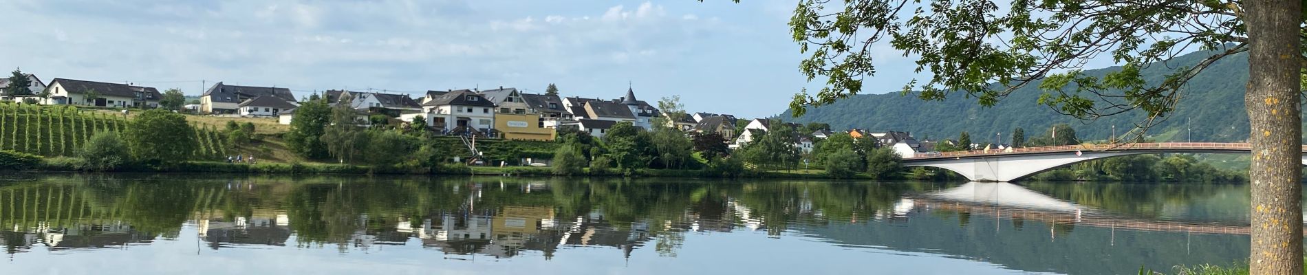
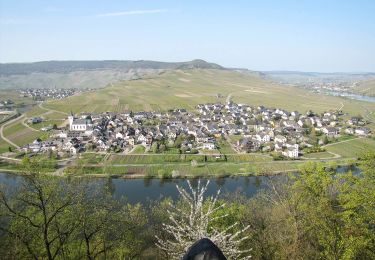
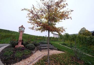
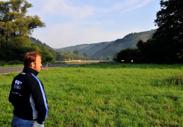
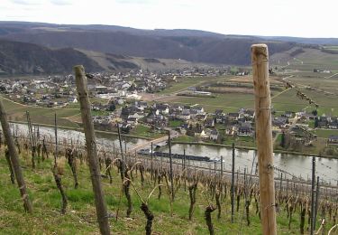
Une balade classique parmi les vignobles escarpés de la Moselle allemande et dans la campagne et les bois. Elle démarre de Piesport, un petit bourg viticole, remonte vers Kesten après une belle séquence forestière et une source ferrugineuse appréciée, dit-on, des Romains. Après Kesten elle grimpe vers les hauteurs boisées pour revenir vers Piesport, où la descente, par des escaliers dans le vignobles, et en même temps un chemin de croix, parcouru à rebours. D’une chapelle et d’une grotte de Lourde vers Piesport, où quelques terrasses attendent les randonneurs déshydratés (et des caves à vin).
Localisation
Commentaires
Randonnées à proximité
![Randonnée A pied Minheim - Sonneninselrundweg - Photo](https://media.geolcdn.com/t/375/260/02d4e434-67f2-4535-850a-d49206583d96.jpeg&format=jpg&maxdim=2)
![A pied A pied](https://static1.geolcdn.com/sitytour/trail-icons/100.png)
A pied
![](/images/other/stat-length.png)
![](https://static1.geolcdn.com/siteimages/upload/files/16400158638029165_repeat_loop_refresh_sync_direction_icon.png)
![Randonnée A pied Minheim - Minheimer Wald - Photo](https://media.geolcdn.com/t/375/260/6b8b8df9-9d1f-40c8-b4ec-90ae477e67d6.jpeg&format=jpg&maxdim=2)
![A pied A pied](https://static1.geolcdn.com/sitytour/trail-icons/100.png)
A pied
![](/images/other/stat-length.png)
![](https://static1.geolcdn.com/siteimages/upload/files/16400158638029165_repeat_loop_refresh_sync_direction_icon.png)
![Randonnée A pied Minheim - Weinerlebnispfad Minheim - Photo](https://media.geolcdn.com/t/375/260/9ce3b244-b610-41d8-a3df-2bfab6f536db.jpeg&format=jpg&maxdim=2)
![A pied A pied](https://static1.geolcdn.com/sitytour/trail-icons/100.png)
A pied
![](/images/other/stat-length.png)
![](https://static1.geolcdn.com/siteimages/upload/files/16400158638029165_repeat_loop_refresh_sync_direction_icon.png)
![Randonnée A pied Neumagen-Dhron - Dhrontalweg - Photo](https://media.geolcdn.com/t/375/260/c23b74f1-7633-49ff-aad5-71685b050079.jpeg&format=jpg&maxdim=2)
![A pied A pied](https://static1.geolcdn.com/sitytour/trail-icons/100.png)
A pied
![](/images/other/stat-length.png)
![](https://static1.geolcdn.com/siteimages/upload/files/16400158638029165_repeat_loop_refresh_sync_direction_icon.png)
![Randonnée A pied Klüsserath - Klüsserather Sagenweg - Photo](https://media.geolcdn.com/t/375/260/cbfce692-6b96-499b-a5c7-9a41ce568a69.jpeg&format=jpg&maxdim=2)
![A pied A pied](https://static1.geolcdn.com/sitytour/trail-icons/100.png)
A pied
![](/images/other/stat-length.png)
![](https://static1.geolcdn.com/siteimages/upload/files/16400158638029165_repeat_loop_refresh_sync_direction_icon.png)
![Randonnée A pied Piesport - Piesporter Berg - Photo](https://media.geolcdn.com/t/375/260/0de05dcc-d39a-47b3-9571-cb677240e7b1.jpeg&format=jpg&maxdim=2)
![A pied A pied](https://static1.geolcdn.com/sitytour/trail-icons/100.png)
A pied
![](/images/other/stat-length.png)
![](https://static1.geolcdn.com/siteimages/upload/files/16400158638029165_repeat_loop_refresh_sync_direction_icon.png)
![Randonnée A pied Piesport - Rund um Zimmet - Photo](https://media.geolcdn.com/t/375/260/02d4e434-67f2-4535-850a-d49206583d96.jpeg&format=jpg&maxdim=2)
![A pied A pied](https://static1.geolcdn.com/sitytour/trail-icons/100.png)
A pied
![](/images/other/stat-length.png)
![](https://static1.geolcdn.com/siteimages/upload/files/16400158638029165_repeat_loop_refresh_sync_direction_icon.png)
![Randonnée A pied Osann-Monzel - DE-OM 5 - Photo](https://media.geolcdn.com/t/375/260/0de05dcc-d39a-47b3-9571-cb677240e7b1.jpeg&format=jpg&maxdim=2)
![A pied A pied](https://static1.geolcdn.com/sitytour/trail-icons/100.png)
A pied
![](/images/other/stat-length.png)
![](https://static1.geolcdn.com/siteimages/upload/files/16400158638029165_repeat_loop_refresh_sync_direction_icon.png)
![Randonnée A pied Piesport - Piesporter Moselbogen - Photo](https://media.geolcdn.com/t/375/260/0de05dcc-d39a-47b3-9571-cb677240e7b1.jpeg&format=jpg&maxdim=2)
![A pied A pied](https://static1.geolcdn.com/sitytour/trail-icons/100.png)
A pied
![](/images/other/stat-length.png)
![](https://static1.geolcdn.com/siteimages/upload/files/16400158638029165_repeat_loop_refresh_sync_direction_icon.png)