![](/images/other/stat-length.png)
![Randonnée Marche Larrau - GR 10 8ème étape : chalet d’Iraty - Logibar - Larrau - Photo](https://media.geolcdn.com/t/1900/400/6d61c9c6-fbfc-413d-b8de-6eac1271196a.jpg&format=pjpeg&maxdim=2)
GR 10 8ème étape : chalet d’Iraty - Logibar - Larrau
LEGUE
Utilisateur
![Longueur](/images/other/stat-length.png)
Longueur
19,8 km
![Altitude max](https://static1.geolcdn.com/siteimages/upload/files/1508320355ic_sort_altitude_max_24dp.png)
Altitude max
1420 m
![Dénivelé positif](https://static1.geolcdn.com/siteimages/upload/files/1508320355ic_sort_den_pos_24dp.png)
Dénivelé positif
720 m
![Km-Effort](/images/other/stat-length.png)
Km-Effort
32 km
![Altitude min](https://static1.geolcdn.com/siteimages/upload/files/1508320355ic_sort_altitude_min_24dp.png)
Altitude min
384 m
![Dénivelé négatif](https://static1.geolcdn.com/siteimages/upload/files/1508320355ic_sort_den_neg_24dp.png)
Dénivelé négatif
1447 m
![Boucle](https://static1.geolcdn.com/siteimages/upload/files/16400158638029165_repeat_loop_refresh_sync_direction_icon.png)
Boucle
Non
Date de création :
2021-08-09 07:36:32.0
Dernière modification :
2021-08-09 15:10:54.031
![Marche](https://static1.geolcdn.com/sitytour/trail-icons/101.png)
4h45
Difficulté : Moyen
![Scannez ce code QR pour ouvrir la randonnée dans l'application SityTrail](https://capi.geolives.com/qq0zvz2zws4bq2lad0pu/sitytour/trails/2891622/qr.png?size=200)
Application GPS de randonnée GRATUITE
À propos
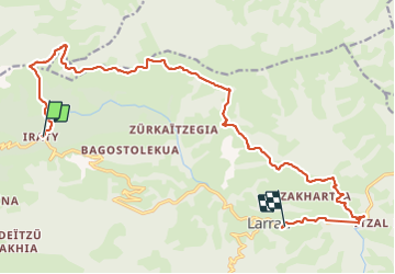
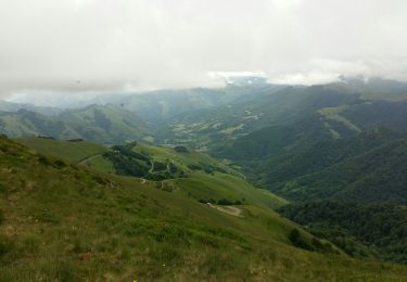
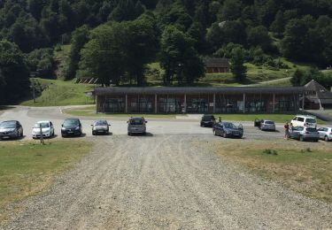
Randonnée Marche de 19,8 km à découvrir à Nouvelle-Aquitaine, Pyrénées-Atlantiques, Larrau. Cette randonnée est proposée par LEGUE.
Description
Étape plutôt facile (750 m de dénivelé positif ) mais 1400 de dénivelés négatifs)
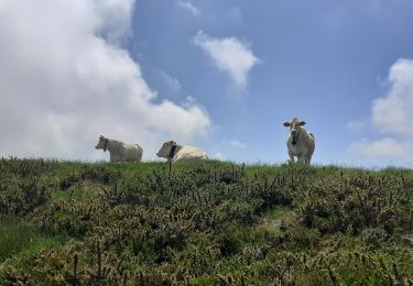
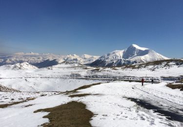
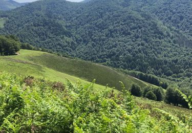
Grand beau
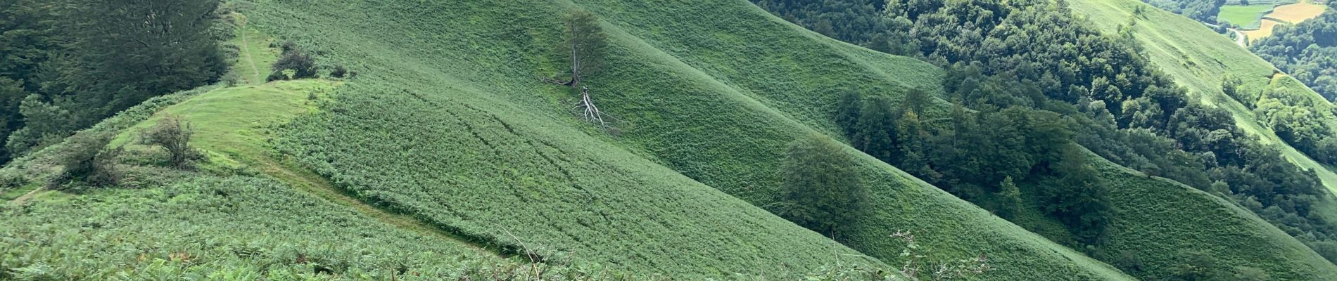
Paysages magnifiques avec des balcons sur vide superbe
Localisation
Pays :
France
Région :
Nouvelle-Aquitaine
Département/Province :
Pyrénées-Atlantiques
Commune :
Larrau
Localité :
Unknown
Départ:(Dec)
Départ:(UTM)
660738 ; 4766959 (30T) N.
Commentaires
Randonnées à proximité
![Randonnée Marche Larrau - IRATY le pic des escaliers sans monter au pic 408M+ 2948308 - Photo](https://media.geolcdn.com/t/375/260/1725c3fb-51a3-4e7e-9d48-19cb60baeea0.jpg&format=jpg&maxdim=2)
![Marche Marche](https://static1.geolcdn.com/sitytour/trail-icons/101.png)
IRATY le pic des escaliers sans monter au pic 408M+ 2948308
Marche
Difficile
Larrau,
Nouvelle-Aquitaine,
Pyrénées-Atlantiques,
France
![](/images/other/stat-length.png)
7,9 km | 13,4 km-effort
3h 2min
![](https://static1.geolcdn.com/siteimages/upload/files/16400158638029165_repeat_loop_refresh_sync_direction_icon.png)
Oui
![Randonnée Marche Larrau - Iraty cabane ZINGOLATZE - Photo](https://media.geolcdn.com/t/375/260/44ee5c4f-fb20-4eee-9c16-d8a5e8350ada.jpg&format=jpg&maxdim=2)
![Marche Marche](https://static1.geolcdn.com/sitytour/trail-icons/101.png)
Iraty cabane ZINGOLATZE
Marche
Très facile
Larrau,
Nouvelle-Aquitaine,
Pyrénées-Atlantiques,
France
![](/images/other/stat-length.png)
6,8 km | 9,7 km-effort
3h 29min
![](https://static1.geolcdn.com/siteimages/upload/files/16400158638029165_repeat_loop_refresh_sync_direction_icon.png)
Oui
![Randonnée Marche Larrau - GR 10 T - Photo](https://media.geolcdn.com/t/375/260/5faacc01-4cf0-48af-992e-bb3842b7dc29.jpg&format=jpg&maxdim=2)
![Marche Marche](https://static1.geolcdn.com/sitytour/trail-icons/101.png)
GR 10 T
Marche
Moyen
Larrau,
Nouvelle-Aquitaine,
Pyrénées-Atlantiques,
France
![](/images/other/stat-length.png)
5,3 km | 7 km-effort
1h 40min
![](https://static1.geolcdn.com/siteimages/upload/files/16400158638029165_repeat_loop_refresh_sync_direction_icon.png)
Non
![Randonnée Marche Larrau - le Pic des Escalier - Photo](https://media.geolcdn.com/t/375/260/25a58932-02ea-4249-a083-fd59fc4e847e.jpg&format=jpg&maxdim=2)
![Marche Marche](https://static1.geolcdn.com/sitytour/trail-icons/101.png)
le Pic des Escalier
Marche
Moyen
Larrau,
Nouvelle-Aquitaine,
Pyrénées-Atlantiques,
France
![](/images/other/stat-length.png)
10,4 km | 16,7 km-effort
3h 8min
![](https://static1.geolcdn.com/siteimages/upload/files/16400158638029165_repeat_loop_refresh_sync_direction_icon.png)
Oui
![Randonnée Marche Larrau - Iraty « escaliers » - Photo](https://media.geolcdn.com/t/375/260/42225316-23e6-495d-8c25-50310cc3c362.jpg&format=jpg&maxdim=2)
![Marche Marche](https://static1.geolcdn.com/sitytour/trail-icons/101.png)
Iraty « escaliers »
Marche
Facile
Larrau,
Nouvelle-Aquitaine,
Pyrénées-Atlantiques,
France
![](/images/other/stat-length.png)
19,1 km | 28 km-effort
6h 32min
![](https://static1.geolcdn.com/siteimages/upload/files/16400158638029165_repeat_loop_refresh_sync_direction_icon.png)
Non
![Randonnée Marche Lecumberry - IRATI : GOROSTIBIZKARRA 1340m - Photo](https://media.geolcdn.com/t/375/260/a59d3f76-fd9f-4aca-903e-cf76eaa1cfd9.jpg&format=jpg&maxdim=2)
![Marche Marche](https://static1.geolcdn.com/sitytour/trail-icons/101.png)
IRATI : GOROSTIBIZKARRA 1340m
Marche
Facile
Lecumberry,
Nouvelle-Aquitaine,
Pyrénées-Atlantiques,
France
![](/images/other/stat-length.png)
9,1 km | 13,9 km-effort
2h 41min
![](https://static1.geolcdn.com/siteimages/upload/files/16400158638029165_repeat_loop_refresh_sync_direction_icon.png)
Oui
![Randonnée Marche Larrau - IRATY Chapelle Notre Dame des Neiges et Casas de Irati - Photo](https://media.geolcdn.com/t/375/260/4820dd3f-a315-4e52-ac6d-42397795308f.jpg&format=jpg&maxdim=2)
![Marche Marche](https://static1.geolcdn.com/sitytour/trail-icons/101.png)
IRATY Chapelle Notre Dame des Neiges et Casas de Irati
Marche
Facile
Larrau,
Nouvelle-Aquitaine,
Pyrénées-Atlantiques,
France
![](/images/other/stat-length.png)
22 km | 33 km-effort
6h 22min
![](https://static1.geolcdn.com/siteimages/upload/files/16400158638029165_repeat_loop_refresh_sync_direction_icon.png)
Oui
![Randonnée Marche Lecumberry - IRATY PETRILARRE-HEGIXURIA en boucle - Photo](https://media.geolcdn.com/t/375/260/858f8db3-ac8d-4103-89b2-b5fb262d83c8.jpg&format=jpg&maxdim=2)
![Marche Marche](https://static1.geolcdn.com/sitytour/trail-icons/101.png)
IRATY PETRILARRE-HEGIXURIA en boucle
Marche
Moyen
Lecumberry,
Nouvelle-Aquitaine,
Pyrénées-Atlantiques,
France
![](/images/other/stat-length.png)
13,6 km | 22 km-effort
4h 29min
![](https://static1.geolcdn.com/siteimages/upload/files/16400158638029165_repeat_loop_refresh_sync_direction_icon.png)
Oui
![Randonnée Marche Mendive - Iraty Okabe boucle - Photo](https://media.geolcdn.com/t/375/260/98b751ab-878a-4479-8f7c-dbca11f504de.jpg&format=jpg&maxdim=2)
![Marche Marche](https://static1.geolcdn.com/sitytour/trail-icons/101.png)
Iraty Okabe boucle
Marche
Moyen
Mendive,
Nouvelle-Aquitaine,
Pyrénées-Atlantiques,
France
![](/images/other/stat-length.png)
12,7 km | 20 km-effort
4h 17min
![](https://static1.geolcdn.com/siteimages/upload/files/16400158638029165_repeat_loop_refresh_sync_direction_icon.png)
Oui