![](/images/other/stat-length.png)
![Randonnée Marche Saint-Michel-l'Observatoire - St Michel l'observatoire, chapelle St. Jean et tour de Porchères - Photo](https://media.geolcdn.com/t/1900/400/10ed98fa-5df8-4597-b581-be4dddab71cc.jpg&format=pjpeg&maxdim=2)
St Michel l'observatoire, chapelle St. Jean et tour de Porchères
Daniel.BRUN-PICARD
Utilisateur
![Longueur](/images/other/stat-length.png)
Longueur
8,1 km
![Altitude max](https://static1.geolcdn.com/siteimages/upload/files/1508320355ic_sort_altitude_max_24dp.png)
Altitude max
593 m
![Dénivelé positif](https://static1.geolcdn.com/siteimages/upload/files/1508320355ic_sort_den_pos_24dp.png)
Dénivelé positif
186 m
![Km-Effort](/images/other/stat-length.png)
Km-Effort
10,6 km
![Altitude min](https://static1.geolcdn.com/siteimages/upload/files/1508320355ic_sort_altitude_min_24dp.png)
Altitude min
499 m
![Dénivelé négatif](https://static1.geolcdn.com/siteimages/upload/files/1508320355ic_sort_den_neg_24dp.png)
Dénivelé négatif
186 m
![Boucle](https://static1.geolcdn.com/siteimages/upload/files/16400158638029165_repeat_loop_refresh_sync_direction_icon.png)
Boucle
Oui
Date de création :
2021-08-09 09:25:43.611
Dernière modification :
2021-08-09 20:28:01.418
![Marche](https://static1.geolcdn.com/sitytour/trail-icons/101.png)
2h28
Difficulté : Facile
![Scannez ce code QR pour ouvrir la randonnée dans l'application SityTrail](https://capi.geolives.com/qq0zvz2zws4bq2lad0pu/sitytour/trails/2891433/qr.png?size=200)
Application GPS de randonnée GRATUITE
À propos
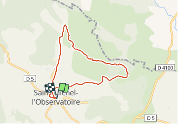
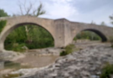
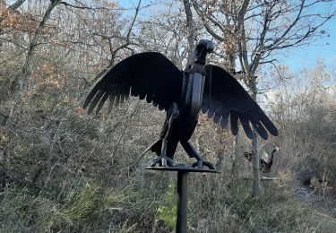
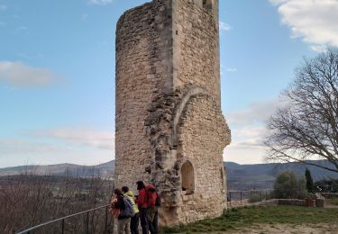
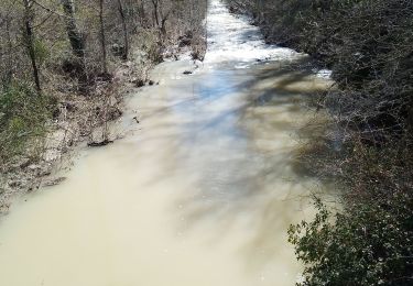
Randonnée Marche de 8,1 km à découvrir à Provence-Alpes-Côte d'Azur, Alpes-de-Haute-Provence, Saint-Michel-l'Observatoire. Cette randonnée est proposée par Daniel.BRUN-PICARD.
Description
Belle randonnée empruntant principalement des routes et larges chemins forestiers.
Localisation
Pays :
France
Région :
Provence-Alpes-Côte d'Azur
Département/Province :
Alpes-de-Haute-Provence
Commune :
Saint-Michel-l'Observatoire
Localité :
Unknown
Départ:(Dec)
Départ:(UTM)
718225 ; 4865366 (31T) N.
Commentaires
Randonnées à proximité
![Randonnée Marche Mane - MANE. Prieuré de Salagon , Pont romain , petit Sauvan , carrières, tour de Pourchere chapelles , ol l s - Photo](https://media.geolcdn.com/t/375/260/d1588e6f-dded-4027-aaae-990874136ea9.jpg&format=jpg&maxdim=2)
![Marche Marche](https://static1.geolcdn.com/sitytour/trail-icons/101.png)
MANE. Prieuré de Salagon , Pont romain , petit Sauvan , carrières, tour de P...
Marche
Moyen
(1)
Mane,
Provence-Alpes-Côte d'Azur,
Alpes-de-Haute-Provence,
France
![](/images/other/stat-length.png)
13,2 km | 17,4 km-effort
3h 50min
![](https://static1.geolcdn.com/siteimages/upload/files/16400158638029165_repeat_loop_refresh_sync_direction_icon.png)
Oui
![Randonnée Marche Dauphin - DAUPHIN La forêt de Pelissier o - Photo](https://media.geolcdn.com/t/375/260/38031732-1577-4607-ab9b-103e2562d975.jpg&format=jpg&maxdim=2)
![Marche Marche](https://static1.geolcdn.com/sitytour/trail-icons/101.png)
DAUPHIN La forêt de Pelissier o
Marche
Moyen
(1)
Dauphin,
Provence-Alpes-Côte d'Azur,
Alpes-de-Haute-Provence,
France
![](/images/other/stat-length.png)
15,2 km | 22 km-effort
4h 6min
![](https://static1.geolcdn.com/siteimages/upload/files/16400158638029165_repeat_loop_refresh_sync_direction_icon.png)
Oui
![Randonnée Marche Saint-Michel-l'Observatoire - LINCEL Moulin de l Agnelie o l - Photo](https://media.geolcdn.com/t/375/260/ext.jpg?maxdim=2&url=https%3A%2F%2Fstatic1.geolcdn.com%2Fsiteimages%2Fupload%2Ffiles%2F1553511878bg_sport_marche.png)
![Marche Marche](https://static1.geolcdn.com/sitytour/trail-icons/101.png)
LINCEL Moulin de l Agnelie o l
Marche
Facile
(1)
Saint-Michel-l'Observatoire,
Provence-Alpes-Côte d'Azur,
Alpes-de-Haute-Provence,
France
![](/images/other/stat-length.png)
13,6 km | 17,8 km-effort
6h 22min
![](https://static1.geolcdn.com/siteimages/upload/files/16400158638029165_repeat_loop_refresh_sync_direction_icon.png)
Oui
![Randonnée Marche Mane - MANE Tours de la laye 3 o - Photo](https://media.geolcdn.com/t/375/260/ext.jpg?maxdim=2&url=https%3A%2F%2Fstatic1.geolcdn.com%2Fsiteimages%2Fupload%2Ffiles%2F1553511878bg_sport_marche.png)
![Marche Marche](https://static1.geolcdn.com/sitytour/trail-icons/101.png)
MANE Tours de la laye 3 o
Marche
Moyen
(1)
Mane,
Provence-Alpes-Côte d'Azur,
Alpes-de-Haute-Provence,
France
![](/images/other/stat-length.png)
15,1 km | 22 km-effort
5h 59min
![](https://static1.geolcdn.com/siteimages/upload/files/16400158638029165_repeat_loop_refresh_sync_direction_icon.png)
Oui
![Randonnée Marche Mane - 110ter-Mane.Les Ybourgues. sans passer par Chateauneuf. Mane - Photo](https://media.geolcdn.com/t/375/260/ext.jpg?maxdim=2&url=https%3A%2F%2Fservices.sitytrail.com%2FGeolivesWS%2FDownloadMedia.ashx%3FTrailID%3D260790%26Media%3Dfix__20140326084226.jpg)
![Marche Marche](https://static1.geolcdn.com/sitytour/trail-icons/101.png)
110ter-Mane.Les Ybourgues. sans passer par Chateauneuf. Mane
Marche
Moyen
(1)
Mane,
Provence-Alpes-Côte d'Azur,
Alpes-de-Haute-Provence,
France
![](/images/other/stat-length.png)
13,2 km | 19,8 km-effort
3h 0min
![](https://static1.geolcdn.com/siteimages/upload/files/16400158638029165_repeat_loop_refresh_sync_direction_icon.png)
Oui
![Randonnée Marche Mane - MANE , pont romain , chapelle S Jean et chapelle Châteauneuf o l s - Photo](https://media.geolcdn.com/t/375/260/f11acae6-d29d-4a56-adfa-70f020f219fb.jpg&format=jpg&maxdim=2)
![Marche Marche](https://static1.geolcdn.com/sitytour/trail-icons/101.png)
MANE , pont romain , chapelle S Jean et chapelle Châteauneuf o l s
Marche
Facile
Mane,
Provence-Alpes-Côte d'Azur,
Alpes-de-Haute-Provence,
France
![](/images/other/stat-length.png)
12,1 km | 16,2 km-effort
3h 1min
![](https://static1.geolcdn.com/siteimages/upload/files/16400158638029165_repeat_loop_refresh_sync_direction_icon.png)
Oui
![Randonnée Marche Mane - MANE Saint Michel Observatoire o - Photo](https://media.geolcdn.com/t/375/260/39e7d3b3-522e-416b-a76a-f14dbd0f25fb.jpg&format=jpg&maxdim=2)
![Marche Marche](https://static1.geolcdn.com/sitytour/trail-icons/101.png)
MANE Saint Michel Observatoire o
Marche
Difficile
Mane,
Provence-Alpes-Côte d'Azur,
Alpes-de-Haute-Provence,
France
![](/images/other/stat-length.png)
18,1 km | 24 km-effort
6h 23min
![](https://static1.geolcdn.com/siteimages/upload/files/16400158638029165_repeat_loop_refresh_sync_direction_icon.png)
Oui
![Randonnée Marche Reillanne - reillane. carluc - Photo](https://media.geolcdn.com/t/375/260/a5a55962-1bef-44bc-99af-6edbc297f6a6.jpg&format=jpg&maxdim=2)
![Marche Marche](https://static1.geolcdn.com/sitytour/trail-icons/101.png)
reillane. carluc
Marche
Moyen
(1)
Reillanne,
Provence-Alpes-Côte d'Azur,
Alpes-de-Haute-Provence,
France
![](/images/other/stat-length.png)
10,8 km | 13,9 km-effort
3h 39min
![](https://static1.geolcdn.com/siteimages/upload/files/16400158638029165_repeat_loop_refresh_sync_direction_icon.png)
Oui
![Randonnée Marche Mane - mane le barrage - Photo](https://media.geolcdn.com/t/375/260/098f335b-b3f2-4d71-9b06-371a5f1d7f65.jpg&format=jpg&maxdim=2)
![Marche Marche](https://static1.geolcdn.com/sitytour/trail-icons/101.png)
mane le barrage
Marche
Moyen
Mane,
Provence-Alpes-Côte d'Azur,
Alpes-de-Haute-Provence,
France
![](/images/other/stat-length.png)
11,5 km | 16,5 km-effort
4h 42min
![](https://static1.geolcdn.com/siteimages/upload/files/16400158638029165_repeat_loop_refresh_sync_direction_icon.png)
Oui