![](/images/other/stat-length.png)
![Randonnée A pied Méhers - Mehers 8 août 2021 - Photo](https://media.geolcdn.com/t/1900/400/2c27c651-b144-43b7-9d95-1f985e6049d3.jpg&format=pjpeg&maxdim=2)
Mehers 8 août 2021
Roro41
Utilisateur
![Longueur](/images/other/stat-length.png)
Longueur
10,9 km
![Altitude max](https://static1.geolcdn.com/siteimages/upload/files/1508320355ic_sort_altitude_max_24dp.png)
Altitude max
98 m
![Dénivelé positif](https://static1.geolcdn.com/siteimages/upload/files/1508320355ic_sort_den_pos_24dp.png)
Dénivelé positif
57 m
![Km-Effort](/images/other/stat-length.png)
Km-Effort
11,7 km
![Altitude min](https://static1.geolcdn.com/siteimages/upload/files/1508320355ic_sort_altitude_min_24dp.png)
Altitude min
79 m
![Dénivelé négatif](https://static1.geolcdn.com/siteimages/upload/files/1508320355ic_sort_den_neg_24dp.png)
Dénivelé négatif
58 m
![Boucle](https://static1.geolcdn.com/siteimages/upload/files/16400158638029165_repeat_loop_refresh_sync_direction_icon.png)
Boucle
Oui
Date de création :
2021-08-08 06:39:01.386
Dernière modification :
2021-08-09 15:19:10.24
![A pied](https://static1.geolcdn.com/sitytour/trail-icons/100.png)
2h39
Difficulté : Facile
![Scannez ce code QR pour ouvrir la randonnée dans l'application SityTrail](https://capi.geolives.com/qq0zvz2zws4bq2lad0pu/sitytour/trails/2889726/qr.png?size=200)
Application GPS de randonnée GRATUITE
À propos
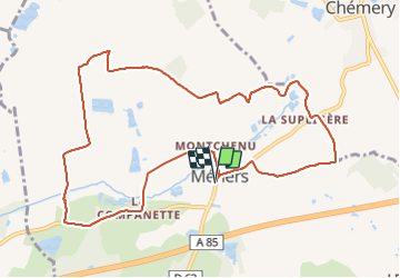
Randonnée A pied de 10,9 km à découvrir à Centre-Val de Loire, Loir-et-Cher, Méhers. Cette randonnée est proposée par Roro41.
Description
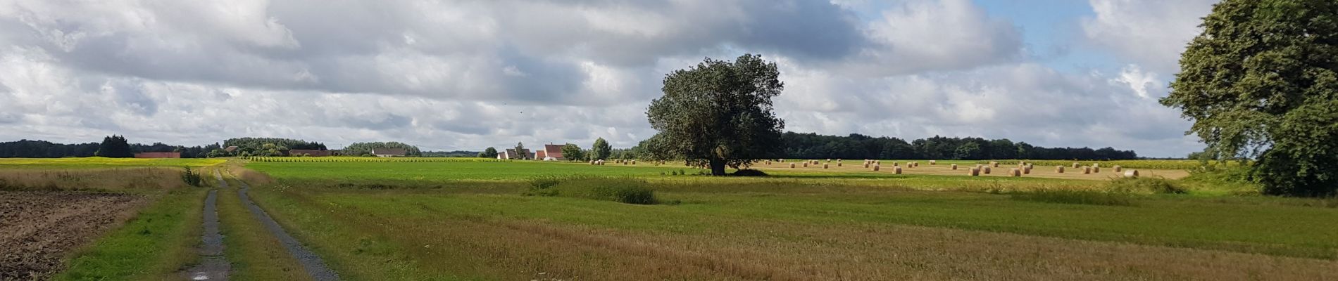
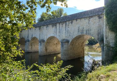
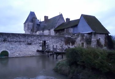
Marche en plaine entre cultures et vignobles. Passage près du château manoir de Beauregard construit dans les premières années du 16e siècle.
Localisation
Pays :
France
Région :
Centre-Val de Loire
Département/Province :
Loir-et-Cher
Commune :
Méhers
Localité :
Unknown
Départ:(Dec)
Départ:(UTM)
383338 ; 5242671 (31T) N.
Commentaires
Randonnées à proximité
![Randonnée sport Chémery - Sob 11 chemery selles sur cher - Photo](https://media.geolcdn.com/t/375/260/023ea4d6-5f56-416d-95d9-c67d7bc970f7.jpg&format=jpg&maxdim=2)
Sob 11 chemery selles sur cher
sport
Très facile
Chémery,
Centre-Val de Loire,
Loir-et-Cher,
France
![](/images/other/stat-length.png)
24 km | 27 km-effort
Inconnu
![](https://static1.geolcdn.com/siteimages/upload/files/16400158638029165_repeat_loop_refresh_sync_direction_icon.png)
Non
![Randonnée Marche Chémery - chemery 2019 - Photo](https://media.geolcdn.com/t/375/260/74a7a3af-7994-42bd-8d40-b60aa8c3cfc3.jpg&format=jpg&maxdim=2)
![Marche Marche](https://static1.geolcdn.com/sitytour/trail-icons/101.png)
chemery 2019
Marche
Très facile
Chémery,
Centre-Val de Loire,
Loir-et-Cher,
France
![](/images/other/stat-length.png)
14,8 km | 16,3 km-effort
2h 59min
![](https://static1.geolcdn.com/siteimages/upload/files/16400158638029165_repeat_loop_refresh_sync_direction_icon.png)
Oui
![Randonnée A pied Chémery - chemery GS 2024 petit - Photo](https://media.geolcdn.com/t/375/260/ext.jpg?maxdim=2&url=https%3A%2F%2Fstatic1.geolcdn.com%2Fsiteimages%2Fupload%2Ffiles%2F1545311037marcheuse_200dpi.jpg)
![A pied A pied](https://static1.geolcdn.com/sitytour/trail-icons/100.png)
chemery GS 2024 petit
A pied
Facile
Chémery,
Centre-Val de Loire,
Loir-et-Cher,
France
![](/images/other/stat-length.png)
10,1 km | 10,9 km-effort
2h 28min
![](https://static1.geolcdn.com/siteimages/upload/files/16400158638029165_repeat_loop_refresh_sync_direction_icon.png)
Oui
![Randonnée Marche Couddes - couddes GS 03 2023 - Photo](https://media.geolcdn.com/t/375/260/ext.jpg?maxdim=2&url=https%3A%2F%2Fstatic1.geolcdn.com%2Fsiteimages%2Fupload%2Ffiles%2F1553511878bg_sport_marche.png)
![Marche Marche](https://static1.geolcdn.com/sitytour/trail-icons/101.png)
couddes GS 03 2023
Marche
Facile
Couddes,
Centre-Val de Loire,
Loir-et-Cher,
France
![](/images/other/stat-length.png)
13,6 km | 14,9 km-effort
3h 0min
![](https://static1.geolcdn.com/siteimages/upload/files/16400158638029165_repeat_loop_refresh_sync_direction_icon.png)
Oui
![Randonnée Marche Chémery - chémery - Photo](https://media.geolcdn.com/t/375/260/ext.jpg?maxdim=2&url=https%3A%2F%2Fstatic1.geolcdn.com%2Fsiteimages%2Fupload%2Ffiles%2F1553511878bg_sport_marche.png)
![Marche Marche](https://static1.geolcdn.com/sitytour/trail-icons/101.png)
chémery
Marche
Moyen
Chémery,
Centre-Val de Loire,
Loir-et-Cher,
France
![](/images/other/stat-length.png)
26 km | 28 km-effort
4h 18min
![](https://static1.geolcdn.com/siteimages/upload/files/16400158638029165_repeat_loop_refresh_sync_direction_icon.png)
Oui
![Randonnée Marche Chémery - çhemery - Photo](https://media.geolcdn.com/t/375/260/ext.jpg?maxdim=2&url=https%3A%2F%2Fstatic1.geolcdn.com%2Fsiteimages%2Fupload%2Ffiles%2F1553511878bg_sport_marche.png)
![Marche Marche](https://static1.geolcdn.com/sitytour/trail-icons/101.png)
çhemery
Marche
Facile
Chémery,
Centre-Val de Loire,
Loir-et-Cher,
France
![](/images/other/stat-length.png)
19,6 km | 22 km-effort
3h 17min
![](https://static1.geolcdn.com/siteimages/upload/files/16400158638029165_repeat_loop_refresh_sync_direction_icon.png)
Oui
![Randonnée A pied Chémery - chemery GS 2022 - Photo](https://media.geolcdn.com/t/375/260/ext.jpg?maxdim=2&url=https%3A%2F%2Fstatic1.geolcdn.com%2Fsiteimages%2Fupload%2Ffiles%2F1545311037marcheuse_200dpi.jpg)
![A pied A pied](https://static1.geolcdn.com/sitytour/trail-icons/100.png)
chemery GS 2022
A pied
Facile
Chémery,
Centre-Val de Loire,
Loir-et-Cher,
France
![](/images/other/stat-length.png)
14,5 km | 15,5 km-effort
3h 0min
![](https://static1.geolcdn.com/siteimages/upload/files/16400158638029165_repeat_loop_refresh_sync_direction_icon.png)
Oui
![Randonnée Marche Saint-Romain-sur-Cher - st romain GS 02/11/2021 petit - Photo](https://media.geolcdn.com/t/375/260/ext.jpg?maxdim=2&url=https%3A%2F%2Fstatic1.geolcdn.com%2Fsiteimages%2Fupload%2Ffiles%2F1553511878bg_sport_marche.png)
![Marche Marche](https://static1.geolcdn.com/sitytour/trail-icons/101.png)
st romain GS 02/11/2021 petit
Marche
Difficile
Saint-Romain-sur-Cher,
Centre-Val de Loire,
Loir-et-Cher,
France
![](/images/other/stat-length.png)
13,4 km | 15,2 km-effort
3h 27min
![](https://static1.geolcdn.com/siteimages/upload/files/16400158638029165_repeat_loop_refresh_sync_direction_icon.png)
Oui
![Randonnée Marche Chémery - chemery - Photo](https://media.geolcdn.com/t/375/260/ext.jpg?maxdim=2&url=https%3A%2F%2Fstatic1.geolcdn.com%2Fsiteimages%2Fupload%2Ffiles%2F1553511878bg_sport_marche.png)
![Marche Marche](https://static1.geolcdn.com/sitytour/trail-icons/101.png)
chemery
Marche
Très facile
Chémery,
Centre-Val de Loire,
Loir-et-Cher,
France
![](/images/other/stat-length.png)
14,4 km | 15,5 km-effort
2h 50min
![](https://static1.geolcdn.com/siteimages/upload/files/16400158638029165_repeat_loop_refresh_sync_direction_icon.png)
Oui