![](/images/other/stat-length.png)
![Randonnée Marche Briançon - La-via-guisane - Photo](https://media.geolcdn.com/t/1900/400/ext.pjpeg?maxdim=2&url=https%3A%2F%2Fstatic1.geolcdn.com%2Fsiteimages%2Fupload%2Ffiles%2F1553511878bg_sport_marche.png)
La-via-guisane
jpb83
Utilisateur
![Longueur](/images/other/stat-length.png)
![Altitude max](https://static1.geolcdn.com/siteimages/upload/files/1508320355ic_sort_altitude_max_24dp.png)
![Dénivelé positif](https://static1.geolcdn.com/siteimages/upload/files/1508320355ic_sort_den_pos_24dp.png)
![Km-Effort](/images/other/stat-length.png)
![Altitude min](https://static1.geolcdn.com/siteimages/upload/files/1508320355ic_sort_altitude_min_24dp.png)
![Dénivelé négatif](https://static1.geolcdn.com/siteimages/upload/files/1508320355ic_sort_den_neg_24dp.png)
![Boucle](https://static1.geolcdn.com/siteimages/upload/files/16400158638029165_repeat_loop_refresh_sync_direction_icon.png)
![Marche](https://static1.geolcdn.com/sitytour/trail-icons/101.png)
2h44
Difficulté : Très facile
![Course à pied](https://static1.geolcdn.com/sitytour/trail-icons/103.png)
1h00
Difficulté : Très facile
![Scannez ce code QR pour ouvrir la randonnée dans l'application SityTrail](https://capi.geolives.com/qq0zvz2zws4bq2lad0pu/sitytour/trails/2888281/qr.png?size=200)
Application GPS de randonnée GRATUITE
À propos
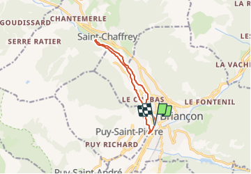
Randonnée Marche de 9,7 km à découvrir à Provence-Alpes-Côte d'Azur, Hautes-Alpes, Briançon. Cette randonnée est proposée par jpb83.
Description
Le parcours des canaux sur le versant nord permet de faire un parcours dont une bonne partie est en forêt entre Briançon et Chantemerle.
Parcours au coeur de la forêt et longeant canal et rivière.
Départ : Avenue René Froger, Briançon
Arrivée : Avenue René Froger Briançon
Communes traversées : Briançon, Saint-Chaffrey, Puy-Saint-Pierre
Stationner votre véhicule et longer la Guisane jusqu'à rejoindre le magasin de bricolage situé sur l'avenue de Provence.
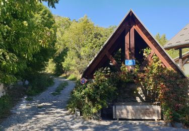
Prendre le sentier qui se situe à côté du pont sur la Guisane jusqu’à l’intersection du chemin de Forville (à 1 km).
Suivre la route vers la gauche en descendant. Laisser le pont pour continuer tout droit le long de la route sous les pins jusqu’au virage en épingle (pont du Martinet).
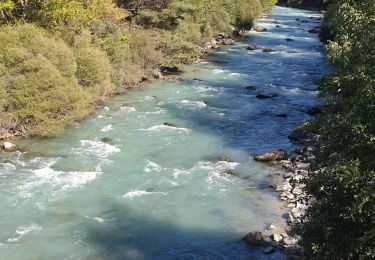
Laisser la route pour emprunter le sentier longeant la rivière en direction de pont Carles par le sentier « Guisane ».
Traverser successivement le pont (au-dessus du torrent du Verdarel) puis le pont Carles (au-dessus de la Guisane).
Désormais sur la rive droite de la Guisane, prendre le canal des Queyrelles et poursuivre jusqu'à rejoindre la route qui monte à Puy Saint Pierre.
Redescendre pour traverser le carrefour et rejoindre le parking
Localisation
Commentaires
Randonnées à proximité
![Randonnée Marche Briançon - Briançon - Parc de la Schappe Cité Vauban Ancien Fort des Trois Têtes - 6.5km 335m 2h05 - 2014 05 28 - Photo](https://media.geolcdn.com/t/375/260/ext.jpg?maxdim=2&url=https%3A%2F%2Fservices.sitytrail.com%2FGeolivesWS%2FDownloadMedia.ashx%3FTrailID%3D307005%26Media%3Dfix__20140528152619.jpg)
![Marche Marche](https://static1.geolcdn.com/sitytour/trail-icons/101.png)
Marche
![](/images/other/stat-length.png)
![](https://static1.geolcdn.com/siteimages/upload/files/16400158638029165_repeat_loop_refresh_sync_direction_icon.png)
![Randonnée V.T.T. Val-des-Prés - Montgenèvre et col de la Lauze - Photo](https://media.geolcdn.com/t/375/260/ext.jpg?maxdim=2&url=https%3A%2F%2Fservices.sitytrail.com%2FGeolivesWS%2FDownloadMedia.ashx%3FTrailID%3D101077%26Media%3D567_3.jpg)
![V.T.T. V.T.T.](https://static1.geolcdn.com/sitytour/trail-icons/202.png)
V.T.T.
![](/images/other/stat-length.png)
![](https://static1.geolcdn.com/siteimages/upload/files/16400158638029165_repeat_loop_refresh_sync_direction_icon.png)
![Randonnée Trail Puy-Saint-André - Clos du Vas - Puy Chalvin - Photo](https://media.geolcdn.com/t/375/260/3737cdbc-e510-4bb6-ac1f-5fcc3e0aab31.jpg&format=jpg&maxdim=2)
![Trail Trail](https://static1.geolcdn.com/sitytour/trail-icons/104.png)
Trail
![](/images/other/stat-length.png)
![](https://static1.geolcdn.com/siteimages/upload/files/16400158638029165_repeat_loop_refresh_sync_direction_icon.png)
![Randonnée Course à pied Puy-Saint-André - Clos du Vas - St Blaise - Briançon - Villar St Pancrace (Hautes-Alpes) - Photo](https://media.geolcdn.com/t/375/260/e9d45fa2-b621-49c0-a347-94f172dd8ddf.jpg&format=jpg&maxdim=2)
![Course à pied Course à pied](https://static1.geolcdn.com/sitytour/trail-icons/103.png)
Course à pied
![](/images/other/stat-length.png)
![](https://static1.geolcdn.com/siteimages/upload/files/16400158638029165_repeat_loop_refresh_sync_direction_icon.png)
![Randonnée Marche Saint-Chaffrey - Chantemerle-la Salle les Aples 13-08-2018 - Photo](https://media.geolcdn.com/t/375/260/ext.jpg?maxdim=2&url=https%3A%2F%2Fstatic1.geolcdn.com%2Fsiteimages%2Fupload%2Ffiles%2F1553511878bg_sport_marche.png)
![Marche Marche](https://static1.geolcdn.com/sitytour/trail-icons/101.png)
Marche
![](/images/other/stat-length.png)
![](https://static1.geolcdn.com/siteimages/upload/files/16400158638029165_repeat_loop_refresh_sync_direction_icon.png)
![Randonnée Marche Puy-Saint-André - cime de la condamine - Photo](https://media.geolcdn.com/t/375/260/ext.jpg?maxdim=2&url=https%3A%2F%2Fservices.sitytrail.com%2FGeolivesWS%2FDownloadMedia.ashx%3FTrailID%3D339114%26Media%3Dfix__20140825141342.jpg)
![Marche Marche](https://static1.geolcdn.com/sitytour/trail-icons/101.png)
Marche
![](/images/other/stat-length.png)
![](https://static1.geolcdn.com/siteimages/upload/files/16400158638029165_repeat_loop_refresh_sync_direction_icon.png)
![Randonnée Marche Briançon - Circuit: Fort des 3 Têtes et Fort Dauphin - Photo](https://media.geolcdn.com/t/375/260/ext.jpg?maxdim=2&url=https%3A%2F%2Fservices.sitytrail.com%2FGeolivesWS%2FDownloadMedia.ashx%3FTrailID%3D164654%26Media%3D20121129113142.jpeg)
![Marche Marche](https://static1.geolcdn.com/sitytour/trail-icons/101.png)
Marche
![](/images/other/stat-length.png)
![](https://static1.geolcdn.com/siteimages/upload/files/16400158638029165_repeat_loop_refresh_sync_direction_icon.png)
![Randonnée Marche Briançon - Briancon: Fort des Trois tètes - Photo](https://media.geolcdn.com/t/375/260/ext.jpg?maxdim=2&url=https%3A%2F%2Fservices.sitytrail.com%2FGeolivesWS%2FDownloadMedia.ashx%3FTrailID%3D163710%26Media%3D20121118161618.jpeg)
![Marche Marche](https://static1.geolcdn.com/sitytour/trail-icons/101.png)
Marche
![](/images/other/stat-length.png)
![](https://static1.geolcdn.com/siteimages/upload/files/16400158638029165_repeat_loop_refresh_sync_direction_icon.png)
![Randonnée Marche Briançon - Briancon: Le tour du Fort des 3 Têtes - Photo](https://media.geolcdn.com/t/375/260/ext.jpg?maxdim=2&url=https%3A%2F%2Fservices.sitytrail.com%2FGeolivesWS%2FDownloadMedia.ashx%3FTrailID%3D158752%26Media%3Dd80e0258-2803-4544-9658-ace38faa0fc2.jpg)
![Marche Marche](https://static1.geolcdn.com/sitytour/trail-icons/101.png)
Marche
![](/images/other/stat-length.png)
![](https://static1.geolcdn.com/siteimages/upload/files/16400158638029165_repeat_loop_refresh_sync_direction_icon.png)