![](/images/other/stat-length.png)
![Randonnée V.T.T. Court-Saint-Étienne - Petit 8 autour de Tangissart par le Ri d'Hé - Photo](https://media.geolcdn.com/t/1900/400/01f9b2b6-73e1-4c0e-bcd0-e3893464b065.jpg&format=pjpeg&maxdim=2)
Petit 8 autour de Tangissart par le Ri d'Hé
Dominique Laine
Utilisateur
![Longueur](/images/other/stat-length.png)
Longueur
7 km
![Altitude max](https://static1.geolcdn.com/siteimages/upload/files/1508320355ic_sort_altitude_max_24dp.png)
Altitude max
133 m
![Dénivelé positif](https://static1.geolcdn.com/siteimages/upload/files/1508320355ic_sort_den_pos_24dp.png)
Dénivelé positif
90 m
![Km-Effort](/images/other/stat-length.png)
Km-Effort
8,2 km
![Altitude min](https://static1.geolcdn.com/siteimages/upload/files/1508320355ic_sort_altitude_min_24dp.png)
Altitude min
76 m
![Dénivelé négatif](https://static1.geolcdn.com/siteimages/upload/files/1508320355ic_sort_den_neg_24dp.png)
Dénivelé négatif
91 m
![Boucle](https://static1.geolcdn.com/siteimages/upload/files/16400158638029165_repeat_loop_refresh_sync_direction_icon.png)
Boucle
Oui
Date de création :
2021-08-04 12:35:04.214
Dernière modification :
2021-08-15 07:53:55.279
![V.T.T.](https://static1.geolcdn.com/sitytour/trail-icons/202.png)
57m
Difficulté : Facile
![Scannez ce code QR pour ouvrir la randonnée dans l'application SityTrail](https://capi.geolives.com/qq0zvz2zws4bq2lad0pu/sitytour/trails/2885146/qr.png?size=200)
Application GPS de randonnée GRATUITE
À propos
Randonnée V.T.T. de 7 km à découvrir à Wallonie, Brabant wallon, Court-Saint-Étienne. Cette randonnée est proposée par Dominique Laine.
Description
La montée de Tangissart jusqu'au "Grand Arbre" est assez raide mais possible. Agréable découverte du vignoble de Bousval. Le retour par le chemin du Ri d'Hé vers Tangissart est très boueux. Choisir un jour précédé d'un temps sec!
Localisation
Pays :
Belgique
Région :
Wallonie
Département/Province :
Brabant wallon
Commune :
Court-Saint-Étienne
Localité :
Unknown
Départ:(Dec)
Départ:(UTM)
609160 ; 5608028 (31U) N.
Commentaires
Randonnées à proximité
![Randonnée Marche Villers-la-Ville - RB-Bw-10_Villers-la-Ville_via-racc-1-et-2 - Photo](https://media.geolcdn.com/t/375/260/ext.jpg?maxdim=2&url=https%3A%2F%2Fservices.sitytrail.com%2FGeolivesWS%2FDownloadMedia.ashx%3FTrailID%3D220359%26Media%3Db52f8a40-bd4e-4201-848f-58c9caafd869.jpg)
![Marche Marche](https://static1.geolcdn.com/sitytour/trail-icons/101.png)
RB-Bw-10_Villers-la-Ville_via-racc-1-et-2
Marche
Difficile
(26)
Villers-la-Ville,
Wallonie,
Brabant wallon,
Belgique
![](/images/other/stat-length.png)
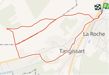
13,3 km | 16,4 km-effort
3h 44min
![](https://static1.geolcdn.com/siteimages/upload/files/16400158638029165_repeat_loop_refresh_sync_direction_icon.png)
Oui
![Randonnée Marche Villers-la-Ville - RB-Bw-10_Villers-la-Ville - Photo](https://media.geolcdn.com/t/375/260/ext.jpg?maxdim=2&url=https%3A%2F%2Fservices.sitytrail.com%2FGeolivesWS%2FDownloadMedia.ashx%3FTrailID%3D220358%26Media%3Db52f8a40-bd4e-4201-848f-58c9caafd869.jpg)
![Marche Marche](https://static1.geolcdn.com/sitytour/trail-icons/101.png)
RB-Bw-10_Villers-la-Ville
Marche
Très difficile
(13)
Villers-la-Ville,
Wallonie,
Brabant wallon,
Belgique
![](/images/other/stat-length.png)
24 km | 30 km-effort
6h 43min
![](https://static1.geolcdn.com/siteimages/upload/files/16400158638029165_repeat_loop_refresh_sync_direction_icon.png)
Oui
![Randonnée Marche Genappe - RB-Bw-09_Bousval_via-racc-1-et-2 - Photo](https://media.geolcdn.com/t/375/260/ext.jpg?maxdim=2&url=https%3A%2F%2Fservices.sitytrail.com%2FGeolivesWS%2FDownloadMedia.ashx%3FTrailID%3D220340%26Media%3Dd40b4c5b-4793-41f9-ac7b-fe40a955ea25.jpg)
![Marche Marche](https://static1.geolcdn.com/sitytour/trail-icons/101.png)
RB-Bw-09_Bousval_via-racc-1-et-2
Marche
Difficile
(11)
Genappe,
Wallonie,
Brabant wallon,
Belgique
![](/images/other/stat-length.png)
9,7 km | 12,5 km-effort
2h 50min
![](https://static1.geolcdn.com/siteimages/upload/files/16400158638029165_repeat_loop_refresh_sync_direction_icon.png)
Oui
![Randonnée Marche Genappe - RB-Bw-09_Bousval-via-racc-2 - Photo](https://media.geolcdn.com/t/375/260/ext.jpg?maxdim=2&url=https%3A%2F%2Fservices.sitytrail.com%2FGeolivesWS%2FDownloadMedia.ashx%3FTrailID%3D220337%26Media%3Dcacfbcff-3084-47a0-8267-9fc97c2da542.jpg)
![Marche Marche](https://static1.geolcdn.com/sitytour/trail-icons/101.png)
RB-Bw-09_Bousval-via-racc-2
Marche
Difficile
(11)
Genappe,
Wallonie,
Brabant wallon,
Belgique
![](/images/other/stat-length.png)
13,2 km | 16,9 km-effort
3h 49min
![](https://static1.geolcdn.com/siteimages/upload/files/16400158638029165_repeat_loop_refresh_sync_direction_icon.png)
Oui
![Randonnée Marche Villers-la-Ville - RB-Bw-10_Villers-la-Ville_via-var - Photo](https://media.geolcdn.com/t/375/260/ext.jpg?maxdim=2&url=https%3A%2F%2Fservices.sitytrail.com%2FGeolivesWS%2FDownloadMedia.ashx%3FTrailID%3D179585%26Media%3Db52f8a40-bd4e-4201-848f-58c9caafd869.jpg)
![Marche Marche](https://static1.geolcdn.com/sitytour/trail-icons/101.png)
RB-Bw-10_Villers-la-Ville_via-var
Marche
Très difficile
(6)
Villers-la-Ville,
Wallonie,
Brabant wallon,
Belgique
![](/images/other/stat-length.png)
26 km | 32 km-effort
7h 15min
![](https://static1.geolcdn.com/siteimages/upload/files/16400158638029165_repeat_loop_refresh_sync_direction_icon.png)
Oui
![Randonnée Marche Genappe - RB-Bw-09_Bousval - Photo](https://media.geolcdn.com/t/375/260/ext.jpg?maxdim=2&url=https%3A%2F%2Fservices.sitytrail.com%2FGeolivesWS%2FDownloadMedia.ashx%3FTrailID%3D179584%26Media%3Dd40b4c5b-4793-41f9-ac7b-fe40a955ea25.jpg)
![Marche Marche](https://static1.geolcdn.com/sitytour/trail-icons/101.png)
RB-Bw-09_Bousval
Marche
Moyen
(9)
Genappe,
Wallonie,
Brabant wallon,
Belgique
![](/images/other/stat-length.png)
22 km | 28 km-effort
5h 59min
![](https://static1.geolcdn.com/siteimages/upload/files/16400158638029165_repeat_loop_refresh_sync_direction_icon.png)
Oui
![Randonnée Marche Genappe - Genappe - Circuit Natura 2000, des sites qui valent le détour ! - Bw03 - Photo](https://media.geolcdn.com/t/375/260/ext.jpg?maxdim=2&url=https%3A%2F%2Fservices.sitytrail.com%2FGeolivesWS%2FDownloadMedia.ashx%3FTrailID%3D356410%26Media%3D9ffde3d0-226c-45a8-b2a5-1fc6dfbe0f90.jpg)
![Marche Marche](https://static1.geolcdn.com/sitytour/trail-icons/101.png)
Genappe - Circuit Natura 2000, des sites qui valent le détour ! - Bw03
Marche
Moyen
(6)
Genappe,
Wallonie,
Brabant wallon,
Belgique
![](/images/other/stat-length.png)
7,9 km | 9,7 km-effort
2h 6min
![](https://static1.geolcdn.com/siteimages/upload/files/16400158638029165_repeat_loop_refresh_sync_direction_icon.png)
Oui
![Randonnée Marche Court-Saint-Étienne - RL-GG-22_La-Roche_Blanmont - Photo](https://media.geolcdn.com/t/375/260/2a6f461f-efef-416e-b536-c468aeb7dc39.jpg&format=jpg&maxdim=2)
![Marche Marche](https://static1.geolcdn.com/sitytour/trail-icons/101.png)
RL-GG-22_La-Roche_Blanmont
Marche
Moyen
(2)
Court-Saint-Étienne,
Wallonie,
Brabant wallon,
Belgique
![](/images/other/stat-length.png)
21 km | 26 km-effort
5h 51min
![](https://static1.geolcdn.com/siteimages/upload/files/16400158638029165_repeat_loop_refresh_sync_direction_icon.png)
Non
![Marche Marche](https://static1.geolcdn.com/sitytour/trail-icons/101.png)
BE-Villers-la-Ville - Sart-Dame-Avelines - Le Bois de Bérines - VLV 9
Marche
Facile
(1)
Villers-la-Ville,
Wallonie,
Brabant wallon,
Belgique
![](/images/other/stat-length.png)
6,4 km | 7,5 km-effort
1h 41min
![](https://static1.geolcdn.com/siteimages/upload/files/16400158638029165_repeat_loop_refresh_sync_direction_icon.png)
Oui