![](/images/other/stat-length.png)
![Randonnée Marche Ancy - ANCY par les crêtes au Nord-Est des Monts du Lyonnais - Photo](https://media.geolcdn.com/t/1900/400/ext.pjpeg?maxdim=2&url=https%3A%2F%2Fstatic1.geolcdn.com%2Fsiteimages%2Fupload%2Ffiles%2F1553511878bg_sport_marche.png)
ANCY par les crêtes au Nord-Est des Monts du Lyonnais
Thomasdanielle
Utilisateur
![Longueur](/images/other/stat-length.png)
Longueur
14,7 km
![Altitude max](https://static1.geolcdn.com/siteimages/upload/files/1508320355ic_sort_altitude_max_24dp.png)
Altitude max
764 m
![Dénivelé positif](https://static1.geolcdn.com/siteimages/upload/files/1508320355ic_sort_den_pos_24dp.png)
Dénivelé positif
520 m
![Km-Effort](/images/other/stat-length.png)
Km-Effort
22 km
![Altitude min](https://static1.geolcdn.com/siteimages/upload/files/1508320355ic_sort_altitude_min_24dp.png)
Altitude min
435 m
![Dénivelé négatif](https://static1.geolcdn.com/siteimages/upload/files/1508320355ic_sort_den_neg_24dp.png)
Dénivelé négatif
520 m
![Boucle](https://static1.geolcdn.com/siteimages/upload/files/16400158638029165_repeat_loop_refresh_sync_direction_icon.png)
Boucle
Oui
Date de création :
2021-08-02 08:08:32.0
Dernière modification :
2021-08-21 09:25:20.12
![Marche](https://static1.geolcdn.com/sitytour/trail-icons/101.png)
5h03
Difficulté : Moyen
![Scannez ce code QR pour ouvrir la randonnée dans l'application SityTrail](https://capi.geolives.com/qq0zvz2zws4bq2lad0pu/sitytour/trails/2882904/qr.png?size=200)
Application GPS de randonnée GRATUITE
À propos
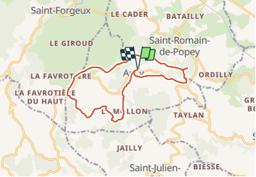
Randonnée Marche de 14,7 km à découvrir à Auvergne-Rhône-Alpes, Rhône, Ancy. Cette randonnée est proposée par Thomasdanielle.
Description
D/A : depuis le parking indiqué et situé à la sortie du village à gauche en venant de Savigny - Saint-Bel. Prendre à gauche la rue centrale, rejoindre le bourg et la mairie
Localisation
Pays :
France
Région :
Auvergne-Rhône-Alpes
Département/Province :
Rhône
Commune :
Ancy
Localité :
Unknown
Départ:(Dec)
Départ:(UTM)
617368 ; 5077268 (31T) N.
Commentaires
Randonnées à proximité
![Randonnée Marche Ancy - SityTrail - ANCY par les crêtes COURT - Photo](https://media.geolcdn.com/t/375/260/ext.jpg?maxdim=2&url=https%3A%2F%2Fstatic1.geolcdn.com%2Fsiteimages%2Fupload%2Ffiles%2F1553511878bg_sport_marche.png)
![Marche Marche](https://static1.geolcdn.com/sitytour/trail-icons/101.png)
SityTrail - ANCY par les crêtes COURT
Marche
Moyen
(1)
Ancy,
Auvergne-Rhône-Alpes,
Rhône,
France
![](/images/other/stat-length.png)
14 km | 20 km-effort
4h 39min
![](https://static1.geolcdn.com/siteimages/upload/files/16400158638029165_repeat_loop_refresh_sync_direction_icon.png)
Oui
![Randonnée Marche Ancy - Amicale_Ancy_12 - Photo](https://media.geolcdn.com/t/375/260/ext.jpg?maxdim=2&url=https%3A%2F%2Fstatic1.geolcdn.com%2Fsiteimages%2Fupload%2Ffiles%2F1553511878bg_sport_marche.png)
![Marche Marche](https://static1.geolcdn.com/sitytour/trail-icons/101.png)
Amicale_Ancy_12
Marche
Difficile
(1)
Ancy,
Auvergne-Rhône-Alpes,
Rhône,
France
![](/images/other/stat-length.png)
12,1 km | 17,4 km-effort
3h 57min
![](https://static1.geolcdn.com/siteimages/upload/files/16400158638029165_repeat_loop_refresh_sync_direction_icon.png)
Oui
![Randonnée Marche Saint-Romain-de-Popey - Les cerisiers de Saint Romain de Popey - Photo](https://media.geolcdn.com/t/375/260/29b9bbfa-dc47-4a87-906f-96dd90692156.jpg&format=jpg&maxdim=2)
![Marche Marche](https://static1.geolcdn.com/sitytour/trail-icons/101.png)
Les cerisiers de Saint Romain de Popey
Marche
Facile
Saint-Romain-de-Popey,
Auvergne-Rhône-Alpes,
Rhône,
France
![](/images/other/stat-length.png)
4,9 km | 7,8 km-effort
3h 10min
![](https://static1.geolcdn.com/siteimages/upload/files/16400158638029165_repeat_loop_refresh_sync_direction_icon.png)
Oui
![Randonnée Marche Bibost - Bibost (69) 18,6 km-D. 719 m - Photo](https://media.geolcdn.com/t/375/260/ext.jpg?maxdim=2&url=https%3A%2F%2Fservices.sitytrail.com%2FGeolivesWS%2FDownloadMedia.ashx%3FTrailID%3D949831%26Media%3D20180423135012.jpg)
![Marche Marche](https://static1.geolcdn.com/sitytour/trail-icons/101.png)
Bibost (69) 18,6 km-D. 719 m
Marche
Difficile
Bibost,
Auvergne-Rhône-Alpes,
Rhône,
France
![](/images/other/stat-length.png)
18,6 km | 28 km-effort
5h 51min
![](https://static1.geolcdn.com/siteimages/upload/files/16400158638029165_repeat_loop_refresh_sync_direction_icon.png)
Oui
![Randonnée Vélo électrique Saint-Romain-de-Popey - matagrin du 19 mars - Photo](https://media.geolcdn.com/t/375/260/ext.jpg?maxdim=2&url=https%3A%2F%2Fservices.sitytrail.com%2FGeolivesWS%2FDownloadMedia.ashx%3FTrailID%3D926851%26Media%3Dfix__20180319132131.jpg)
![Vélo électrique Vélo électrique](https://static1.geolcdn.com/sitytour/trail-icons/205.png)
matagrin du 19 mars
Vélo électrique
Facile
Saint-Romain-de-Popey,
Auvergne-Rhône-Alpes,
Rhône,
France
![](/images/other/stat-length.png)
45 km | 64 km-effort
Inconnu
![](https://static1.geolcdn.com/siteimages/upload/files/16400158638029165_repeat_loop_refresh_sync_direction_icon.png)
Non
![Randonnée Marche Saint-Forgeux - Randonnée de Saint Forgeux à Ronzière - Photo](https://media.geolcdn.com/t/375/260/ext.jpg?maxdim=2&url=https%3A%2F%2Fservices.sitytrail.com%2FGeolivesWS%2FDownloadMedia.ashx%3FTrailID%3D109913%26Media%3D4928_2.jpg)
![Marche Marche](https://static1.geolcdn.com/sitytour/trail-icons/101.png)
Randonnée de Saint Forgeux à Ronzière
Marche
Difficile
Saint-Forgeux,
Auvergne-Rhône-Alpes,
Rhône,
France
![](/images/other/stat-length.png)
11,2 km | 16,8 km-effort
3h 0min
![](https://static1.geolcdn.com/siteimages/upload/files/16400158638029165_repeat_loop_refresh_sync_direction_icon.png)
Oui
![Randonnée Marche Saint-Julien-sur-Bibost - Saint julien sur bibost - Photo](https://media.geolcdn.com/t/375/260/ext.jpg?maxdim=2&url=https%3A%2F%2Fstatic1.geolcdn.com%2Fsiteimages%2Fupload%2Ffiles%2F1553511878bg_sport_marche.png)
![Marche Marche](https://static1.geolcdn.com/sitytour/trail-icons/101.png)
Saint julien sur bibost
Marche
Moyen
Saint-Julien-sur-Bibost,
Auvergne-Rhône-Alpes,
Rhône,
France
![](/images/other/stat-length.png)
24 km | 35 km-effort
5h 44min
![](https://static1.geolcdn.com/siteimages/upload/files/16400158638029165_repeat_loop_refresh_sync_direction_icon.png)
Non
![Randonnée Marche Bibost - Bibost - Photo](https://media.geolcdn.com/t/375/260/ext.jpg?maxdim=2&url=https%3A%2F%2Fstatic1.geolcdn.com%2Fsiteimages%2Fupload%2Ffiles%2F1553511878bg_sport_marche.png)
![Marche Marche](https://static1.geolcdn.com/sitytour/trail-icons/101.png)
Bibost
Marche
Très difficile
(1)
Bibost,
Auvergne-Rhône-Alpes,
Rhône,
France
![](/images/other/stat-length.png)
12,3 km | 19,3 km-effort
4h 23min
![](https://static1.geolcdn.com/siteimages/upload/files/16400158638029165_repeat_loop_refresh_sync_direction_icon.png)
Oui
![Randonnée Cheval Montrottier - Montrottier 28km - Photo](https://media.geolcdn.com/t/375/260/ext.jpg?maxdim=2&url=https%3A%2F%2Fstatic1.geolcdn.com%2Fsiteimages%2Fupload%2Ffiles%2F1524743154cheval.jpg)
![Cheval Cheval](https://static1.geolcdn.com/sitytour/trail-icons/300.png)
Montrottier 28km
Cheval
Facile
Montrottier,
Auvergne-Rhône-Alpes,
Rhône,
France
![](/images/other/stat-length.png)
28 km | 42 km-effort
Inconnu
![](https://static1.geolcdn.com/siteimages/upload/files/16400158638029165_repeat_loop_refresh_sync_direction_icon.png)
Non