![](/images/other/stat-length.png)
![Randonnée Marche Condette - Les trois visages de la forêt d'Ecault - Photo](https://media.geolcdn.com/t/1900/400/ext.pjpeg?maxdim=2&url=https%3A%2F%2Fstatic1.geolcdn.com%2Fsiteimages%2Fupload%2Ffiles%2F1553511878bg_sport_marche.png)
Les trois visages de la forêt d'Ecault
Baltykatt
Utilisateur
![Longueur](/images/other/stat-length.png)
Longueur
8,1 km
![Altitude max](https://static1.geolcdn.com/siteimages/upload/files/1508320355ic_sort_altitude_max_24dp.png)
Altitude max
45 m
![Dénivelé positif](https://static1.geolcdn.com/siteimages/upload/files/1508320355ic_sort_den_pos_24dp.png)
Dénivelé positif
75 m
![Km-Effort](/images/other/stat-length.png)
Km-Effort
9,1 km
![Altitude min](https://static1.geolcdn.com/siteimages/upload/files/1508320355ic_sort_altitude_min_24dp.png)
Altitude min
0 m
![Dénivelé négatif](https://static1.geolcdn.com/siteimages/upload/files/1508320355ic_sort_den_neg_24dp.png)
Dénivelé négatif
75 m
![Boucle](https://static1.geolcdn.com/siteimages/upload/files/16400158638029165_repeat_loop_refresh_sync_direction_icon.png)
Boucle
Oui
Date de création :
2021-08-02 07:42:31.134
Dernière modification :
2021-08-02 08:01:56.754
![Marche](https://static1.geolcdn.com/sitytour/trail-icons/101.png)
2h04
Difficulté : Moyen
![Scannez ce code QR pour ouvrir la randonnée dans l'application SityTrail](https://capi.geolives.com/qq0zvz2zws4bq2lad0pu/sitytour/trails/2882338/qr.png?size=200)
Application GPS de randonnée GRATUITE
À propos
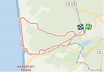
Randonnée Marche de 8,1 km à découvrir à Hauts-de-France, Pas-de-Calais, Condette. Cette randonnée est proposée par Baltykatt.
Description
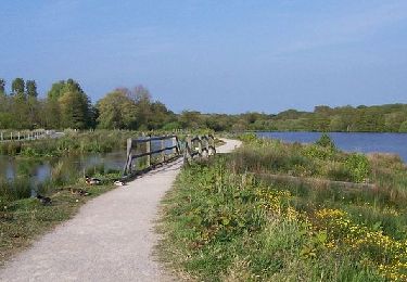
A travers cette balade, vous découvrirez les abords du château de l'Entente Cordiale et son marais, la forêt de pins, le paysage dunaire et ses blockhaus, l'immense plage de sable fin d'Hardelot.
Localisation
Pays :
France
Région :
Hauts-de-France
Département/Province :
Pas-de-Calais
Commune :
Condette
Localité :
Unknown
Départ:(Dec)
Départ:(UTM)
401920 ; 5611506 (31U) N.
Commentaires
Randonnées à proximité
![Randonnée Marche Saint-Étienne-au-Mont - Plages et Dunes d'Ecault - Saint-Étienne au Mont - Photo](https://media.geolcdn.com/t/375/260/ext.jpg?maxdim=2&url=https%3A%2F%2Fservices.sitytrail.com%2FGeolivesWS%2FDownloadMedia.ashx%3FTrailID%3D105594%26Media%3D9363_5.jpg)
![Marche Marche](https://static1.geolcdn.com/sitytour/trail-icons/101.png)
Plages et Dunes d'Ecault - Saint-Étienne au Mont
Marche
Moyen
(2)
Saint-Étienne-au-Mont,
Hauts-de-France,
Pas-de-Calais,
France
![](/images/other/stat-length.png)
5,7 km | 7,1 km-effort
1h 45min
![](https://static1.geolcdn.com/siteimages/upload/files/16400158638029165_repeat_loop_refresh_sync_direction_icon.png)
Oui
![Randonnée Marche Nesles - Mont Violette - Nesles - Photo](https://media.geolcdn.com/t/375/260/ext.jpg?maxdim=2&url=https%3A%2F%2Fservices.sitytrail.com%2FGeolivesWS%2FDownloadMedia.ashx%3FTrailID%3D103681%26Media%3D6162_4.jpg)
![Marche Marche](https://static1.geolcdn.com/sitytour/trail-icons/101.png)
Mont Violette - Nesles
Marche
Moyen
(1)
Nesles,
Hauts-de-France,
Pas-de-Calais,
France
![](/images/other/stat-length.png)
11,6 km | 15,4 km-effort
3h 0min
![](https://static1.geolcdn.com/siteimages/upload/files/16400158638029165_repeat_loop_refresh_sync_direction_icon.png)
Oui
![Randonnée Marche Équihen-Plage - Le sentier des dunes - Photo](https://media.geolcdn.com/t/375/260/e841b20b-a021-46ec-a72e-4851210a1f6f.jpg&format=jpg&maxdim=2)
![Marche Marche](https://static1.geolcdn.com/sitytour/trail-icons/101.png)
Le sentier des dunes
Marche
Facile
(2)
Équihen-Plage,
Hauts-de-France,
Pas-de-Calais,
France
![](/images/other/stat-length.png)
5,5 km | 6,9 km-effort
1h 59min
![](https://static1.geolcdn.com/siteimages/upload/files/16400158638029165_repeat_loop_refresh_sync_direction_icon.png)
Oui
![Randonnée Marche nordique Neufchâtel-Hardelot - Hardelot Plage - Photo](https://media.geolcdn.com/t/375/260/ext.jpg?maxdim=2&url=https%3A%2F%2Fstatic1.geolcdn.com%2Fsiteimages%2Fupload%2Ffiles%2F1545311037marcheuse_200dpi.jpg)
![Marche nordique Marche nordique](https://static1.geolcdn.com/sitytour/trail-icons/102.png)
Hardelot Plage
Marche nordique
Facile
(1)
Neufchâtel-Hardelot,
Hauts-de-France,
Pas-de-Calais,
France
![](/images/other/stat-length.png)
4,5 km | 4,9 km-effort
1h 3min
![](https://static1.geolcdn.com/siteimages/upload/files/16400158638029165_repeat_loop_refresh_sync_direction_icon.png)
Oui
![Randonnée Marche Neufchâtel-Hardelot - Hardelot2 - Photo](https://media.geolcdn.com/t/375/260/ext.jpg?maxdim=2&url=https%3A%2F%2Fservices.sitytrail.com%2FGeolivesWS%2FDownloadMedia.ashx%3FTrailID%3D511214%26Media%3Dfix__20150920111236.jpg)
![Marche Marche](https://static1.geolcdn.com/sitytour/trail-icons/101.png)
Hardelot2
Marche
Moyen
Neufchâtel-Hardelot,
Hauts-de-France,
Pas-de-Calais,
France
![](/images/other/stat-length.png)
9,3 km | 10,5 km-effort
2h 19min
![](https://static1.geolcdn.com/siteimages/upload/files/16400158638029165_repeat_loop_refresh_sync_direction_icon.png)
Oui
![Randonnée Marche Saint-Étienne-au-Mont - Sentier de la Chapelle - Saint-Etienne-au-Mont - Photo](https://media.geolcdn.com/t/375/260/ext.jpg?maxdim=2&url=https%3A%2F%2Fservices.sitytrail.com%2FGeolivesWS%2FDownloadMedia.ashx%3FTrailID%3D317856%26Media%3D17239_3.jpg)
![Marche Marche](https://static1.geolcdn.com/sitytour/trail-icons/101.png)
Sentier de la Chapelle - Saint-Etienne-au-Mont
Marche
Facile
Saint-Étienne-au-Mont,
Hauts-de-France,
Pas-de-Calais,
France
![](/images/other/stat-length.png)
7,1 km | 9,8 km-effort
2h 0min
![](https://static1.geolcdn.com/siteimages/upload/files/16400158638029165_repeat_loop_refresh_sync_direction_icon.png)
Oui
![Randonnée Marche Hesdigneul-lès-Boulogne - Circuit Sentier du Mont des Prêtres - Hesdigneul les Boulogne - Photo](https://media.geolcdn.com/t/375/260/ext.jpg?maxdim=2&url=https%3A%2F%2Fservices.sitytrail.com%2FGeolivesWS%2FDownloadMedia.ashx%3FTrailID%3D317851%26Media%3D17230_3.jpg)
![Marche Marche](https://static1.geolcdn.com/sitytour/trail-icons/101.png)
Circuit Sentier du Mont des Prêtres - Hesdigneul les Boulogne
Marche
Facile
(2)
Hesdigneul-lès-Boulogne,
Hauts-de-France,
Pas-de-Calais,
France
![](/images/other/stat-length.png)
5,2 km | 6,1 km-effort
1h 30min
![](https://static1.geolcdn.com/siteimages/upload/files/16400158638029165_repeat_loop_refresh_sync_direction_icon.png)
Oui
![Randonnée Cheval Condette - Circuit de la Warenne - Condette - Photo](https://media.geolcdn.com/t/375/260/ext.jpg?maxdim=2&url=https%3A%2F%2Fservices.sitytrail.com%2FGeolivesWS%2FDownloadMedia.ashx%3FTrailID%3D316913%26Media%3D16012_6.jpg)
![Cheval Cheval](https://static1.geolcdn.com/sitytour/trail-icons/300.png)
Circuit de la Warenne - Condette
Cheval
Moyen
Condette,
Hauts-de-France,
Pas-de-Calais,
France
![](/images/other/stat-length.png)
11 km | 12,8 km-effort
2h 0min
![](https://static1.geolcdn.com/siteimages/upload/files/16400158638029165_repeat_loop_refresh_sync_direction_icon.png)
Oui
![Randonnée Cheval Condette - Circuit d'Ecames et de la forêt d'Hardelot - Condette - Photo](https://media.geolcdn.com/t/375/260/ext.jpg?maxdim=2&url=https%3A%2F%2Fservices.sitytrail.com%2FGeolivesWS%2FDownloadMedia.ashx%3FTrailID%3D316912%26Media%3D16011_3.jpg)
![Cheval Cheval](https://static1.geolcdn.com/sitytour/trail-icons/300.png)
Circuit d'Ecames et de la forêt d'Hardelot - Condette
Cheval
Moyen
(1)
Condette,
Hauts-de-France,
Pas-de-Calais,
France
![](/images/other/stat-length.png)
12,8 km | 14,5 km-effort
2h 0min
![](https://static1.geolcdn.com/siteimages/upload/files/16400158638029165_repeat_loop_refresh_sync_direction_icon.png)
Oui