![](/images/other/stat-length.png)
![Randonnée A pied Troisvaux - belval NORD vers Huclier - Photo](https://media.geolcdn.com/t/1900/400/ext.pjpeg?maxdim=2&url=https%3A%2F%2Fstatic1.geolcdn.com%2Fsiteimages%2Fupload%2Ffiles%2F1545311037marcheuse_200dpi.jpg)
belval NORD vers Huclier
eaea7charles
Utilisateur
![Longueur](/images/other/stat-length.png)
Longueur
22 km
![Altitude max](https://static1.geolcdn.com/siteimages/upload/files/1508320355ic_sort_altitude_max_24dp.png)
Altitude max
157 m
![Dénivelé positif](https://static1.geolcdn.com/siteimages/upload/files/1508320355ic_sort_den_pos_24dp.png)
Dénivelé positif
313 m
![Km-Effort](/images/other/stat-length.png)
Km-Effort
27 km
![Altitude min](https://static1.geolcdn.com/siteimages/upload/files/1508320355ic_sort_altitude_min_24dp.png)
Altitude min
69 m
![Dénivelé négatif](https://static1.geolcdn.com/siteimages/upload/files/1508320355ic_sort_den_neg_24dp.png)
Dénivelé négatif
313 m
![Boucle](https://static1.geolcdn.com/siteimages/upload/files/16400158638029165_repeat_loop_refresh_sync_direction_icon.png)
Boucle
Oui
Date de création :
2021-08-02 07:13:56.13
Dernière modification :
2021-08-02 07:17:18.203
![A pied](https://static1.geolcdn.com/sitytour/trail-icons/100.png)
6h01
Difficulté : Moyen
![Scannez ce code QR pour ouvrir la randonnée dans l'application SityTrail](https://capi.geolives.com/qq0zvz2zws4bq2lad0pu/sitytour/trails/2882314/qr.png?size=200)
Application GPS de randonnée GRATUITE
À propos
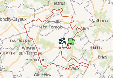
Randonnée A pied de 22 km à découvrir à Hauts-de-France, Pas-de-Calais, Troisvaux. Cette randonnée est proposée par eaea7charles.
Description
Boucle de 22 km au départ de l'ancienne abbaye de Belval, vers Huclier, Conteville en ternois, Wavrans sur ternoise et Troisvaux
Localisation
Pays :
France
Région :
Hauts-de-France
Département/Province :
Pas-de-Calais
Commune :
Troisvaux
Localité :
Unknown
Départ:(Dec)
Départ:(UTM)
453087 ; 5585079 (31U) N.
Commentaires
Randonnées à proximité
![Randonnée Marche Troisvaux - Autour de l'abbaye de Belval - Photo](https://media.geolcdn.com/t/375/260/ext.jpg?maxdim=2&url=https%3A%2F%2Fservices.sitytrail.com%2FGeolivesWS%2FDownloadMedia.ashx%3FTrailID%3D549609%26Media%3Dfix__20160403103418.jpg)
![Marche Marche](https://static1.geolcdn.com/sitytour/trail-icons/101.png)
Autour de l'abbaye de Belval
Marche
Facile
Troisvaux,
Hauts-de-France,
Pas-de-Calais,
France
![](/images/other/stat-length.png)
25 km | 30 km-effort
5h 9min
![](https://static1.geolcdn.com/siteimages/upload/files/16400158638029165_repeat_loop_refresh_sync_direction_icon.png)
Oui
![Randonnée Marche Troisvaux - Autour de l'abbaye de Belval - Photo](https://media.geolcdn.com/t/375/260/ext.jpg?maxdim=2&url=https%3A%2F%2Fservices.sitytrail.com%2FGeolivesWS%2FDownloadMedia.ashx%3FTrailID%3D548655%26Media%3Dfix__20160403140649.jpg)
![Marche Marche](https://static1.geolcdn.com/sitytour/trail-icons/101.png)
Autour de l'abbaye de Belval
Marche
Facile
Troisvaux,
Hauts-de-France,
Pas-de-Calais,
France
![](/images/other/stat-length.png)
25 km | 30 km-effort
6h 26min
![](https://static1.geolcdn.com/siteimages/upload/files/16400158638029165_repeat_loop_refresh_sync_direction_icon.png)
Oui
![Randonnée Quad Huclier - Tangry - Photo](https://media.geolcdn.com/t/375/260/ext.jpg?maxdim=2&url=https%3A%2F%2Fstatic1.geolcdn.com%2Fsiteimages%2Fupload%2Ffiles%2F15247431544x4.jpg)
![Quad Quad](https://static1.geolcdn.com/sitytour/trail-icons/404.png)
![Randonnée Autre activité Saint-Pol-sur-Ternoise - Nord - Pas-de-Calais - Ligne 289 - Saint-Pol-sur-Ternoise - Abbeville - Photo](https://media.geolcdn.com/t/375/260/ext.jpg?maxdim=2&url=https%3A%2F%2Fstatic1.geolcdn.com%2Fsiteimages%2Fupload%2Ffiles%2F1545311037marcheuse_200dpi.jpg)
![Autre activité Autre activité](https://static1.geolcdn.com/sitytour/trail-icons/900.png)
Nord - Pas-de-Calais - Ligne 289 - Saint-Pol-sur-Ternoise - Abbeville
Autre activité
Très facile
Saint-Pol-sur-Ternoise,
Hauts-de-France,
Pas-de-Calais,
France
![](/images/other/stat-length.png)
35 km | 40 km-effort
5min
![](https://static1.geolcdn.com/siteimages/upload/files/16400158638029165_repeat_loop_refresh_sync_direction_icon.png)
Non
![Randonnée Vélo de route Saint-Pol-sur-Ternoise - CCL NO 5. Huby st Leu. Départ ST POL SUR TERNOISE. Lieux de mémoire. - Photo](https://media.geolcdn.com/t/375/260/ext.jpg?maxdim=2&url=https%3A%2F%2Fstatic1.geolcdn.com%2Fsiteimages%2Fupload%2Ffiles%2F1524743154velo.jpg)
![Vélo de route Vélo de route](https://static1.geolcdn.com/sitytour/trail-icons/201.png)
CCL NO 5. Huby st Leu. Départ ST POL SUR TERNOISE. Lieux de mémoire.
Vélo de route
Très difficile
Saint-Pol-sur-Ternoise,
Hauts-de-France,
Pas-de-Calais,
France
![](/images/other/stat-length.png)
80 km | 91 km-effort
5h 29min
![](https://static1.geolcdn.com/siteimages/upload/files/16400158638029165_repeat_loop_refresh_sync_direction_icon.png)
Oui
![Randonnée Marche Troisvaux - Belval 21.3km départ abbaye - Photo](https://media.geolcdn.com/t/375/260/ext.jpg?maxdim=2&url=https%3A%2F%2Fstatic1.geolcdn.com%2Fsiteimages%2Fupload%2Ffiles%2F1553511878bg_sport_marche.png)
![Marche Marche](https://static1.geolcdn.com/sitytour/trail-icons/101.png)
Belval 21.3km départ abbaye
Marche
Très difficile
Troisvaux,
Hauts-de-France,
Pas-de-Calais,
France
![](/images/other/stat-length.png)
21 km | 25 km-effort
5h 44min
![](https://static1.geolcdn.com/siteimages/upload/files/16400158638029165_repeat_loop_refresh_sync_direction_icon.png)
Oui
![Randonnée A pied Saint-Pol-sur-Ternoise - Le Fossé Cagnu / Saint-Pol sur Ternoise / France - Photo](https://media.geolcdn.com/t/375/260/ext.jpg?maxdim=2&url=https%3A%2F%2Fstatic1.geolcdn.com%2Fsiteimages%2Fupload%2Ffiles%2F1545311037marcheuse_200dpi.jpg)
![A pied A pied](https://static1.geolcdn.com/sitytour/trail-icons/100.png)
Le Fossé Cagnu / Saint-Pol sur Ternoise / France
A pied
Moyen
Saint-Pol-sur-Ternoise,
Hauts-de-France,
Pas-de-Calais,
France
![](/images/other/stat-length.png)
10,7 km | 12,5 km-effort
Inconnu
![](https://static1.geolcdn.com/siteimages/upload/files/16400158638029165_repeat_loop_refresh_sync_direction_icon.png)
Oui
![Randonnée Marche Hernicourt - Hernicourt - Photo](https://media.geolcdn.com/t/375/260/ext.jpg?maxdim=2&url=https%3A%2F%2Fstatic1.geolcdn.com%2Fsiteimages%2Fupload%2Ffiles%2F1553511878bg_sport_marche.png)
![Marche Marche](https://static1.geolcdn.com/sitytour/trail-icons/101.png)
Hernicourt
Marche
Moyen
Hernicourt,
Hauts-de-France,
Pas-de-Calais,
France
![](/images/other/stat-length.png)
19,3 km | 22 km-effort
4h 32min
![](https://static1.geolcdn.com/siteimages/upload/files/16400158638029165_repeat_loop_refresh_sync_direction_icon.png)
Oui
![Randonnée Marche Bours - pt tour du donjon - Photo](https://media.geolcdn.com/t/375/260/ext.jpg?maxdim=2&url=https%3A%2F%2Fstatic1.geolcdn.com%2Fsiteimages%2Fupload%2Ffiles%2F1553511878bg_sport_marche.png)
![Marche Marche](https://static1.geolcdn.com/sitytour/trail-icons/101.png)
pt tour du donjon
Marche
Très facile
Bours,
Hauts-de-France,
Pas-de-Calais,
France
![](/images/other/stat-length.png)
6,9 km | 8,4 km-effort
1h 37min
![](https://static1.geolcdn.com/siteimages/upload/files/16400158638029165_repeat_loop_refresh_sync_direction_icon.png)
Oui