


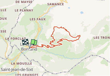

13,2 km | 28 km-effort

Utilisateur GUIDE


Application GPS de randonnée GRATUITE
 SityTrail
IGN / Instituts géographiques
SityTrail World
Le monde est à vous
Randonnée V.T.T. de 18,4 km à découvrir à Auvergne-Rhône-Alpes, Haute-Savoie, Le Grand-Bornand. Cette randonnée est proposée par pascalou73.
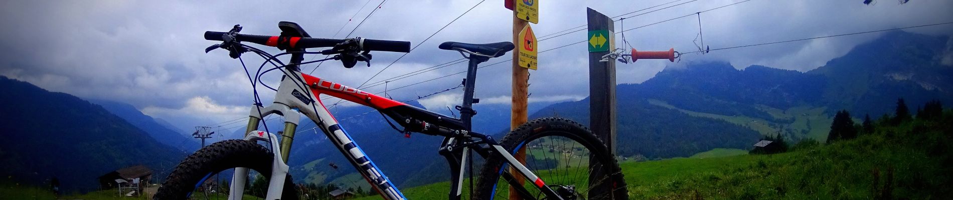
Voilà une des 3 randonnées VTT sur le grand bornait une très belle sortie VTT dans une belle région avec des beaux points de vue sur les montages .Une des plus belles stations des Alpes française .Le domaine VTT de la Grand-Bornand décroule 178 km de pistes VTT ici je vous propose une des randonnées la N3 le tour des Arces au départ du camping de l'escale.
 "
data-pinterest-text="Pin it"
data-tweet-text="share on twitter"
data-facebook-share-url="https://www.sitytrail.com/fr/trails/2880608-le-grandxbornand--vtt-sur-le_grand_bornand-xle-tour-des-arcesx/?photo=1#lg=1&slide=1"
data-twitter-share-url="https://www.sitytrail.com/fr/trails/2880608-le-grandxbornand--vtt-sur-le_grand_bornand-xle-tour-des-arcesx/?photo=1#lg=1&slide=1"
data-googleplus-share-url="https://www.sitytrail.com/fr/trails/2880608-le-grandxbornand--vtt-sur-le_grand_bornand-xle-tour-des-arcesx/?photo=1#lg=1&slide=1"
data-pinterest-share-url="https://www.sitytrail.com/fr/trails/2880608-le-grandxbornand--vtt-sur-le_grand_bornand-xle-tour-des-arcesx/?photo=1#lg=1&slide=1">
"
data-pinterest-text="Pin it"
data-tweet-text="share on twitter"
data-facebook-share-url="https://www.sitytrail.com/fr/trails/2880608-le-grandxbornand--vtt-sur-le_grand_bornand-xle-tour-des-arcesx/?photo=1#lg=1&slide=1"
data-twitter-share-url="https://www.sitytrail.com/fr/trails/2880608-le-grandxbornand--vtt-sur-le_grand_bornand-xle-tour-des-arcesx/?photo=1#lg=1&slide=1"
data-googleplus-share-url="https://www.sitytrail.com/fr/trails/2880608-le-grandxbornand--vtt-sur-le_grand_bornand-xle-tour-des-arcesx/?photo=1#lg=1&slide=1"
data-pinterest-share-url="https://www.sitytrail.com/fr/trails/2880608-le-grandxbornand--vtt-sur-le_grand_bornand-xle-tour-des-arcesx/?photo=1#lg=1&slide=1">
 "
data-pinterest-text="Pin it"
data-tweet-text="share on twitter"
data-facebook-share-url="https://www.sitytrail.com/fr/trails/2880608-le-grandxbornand--vtt-sur-le_grand_bornand-xle-tour-des-arcesx/?photo=2#lg=1&slide=2"
data-twitter-share-url="https://www.sitytrail.com/fr/trails/2880608-le-grandxbornand--vtt-sur-le_grand_bornand-xle-tour-des-arcesx/?photo=2#lg=1&slide=2"
data-googleplus-share-url="https://www.sitytrail.com/fr/trails/2880608-le-grandxbornand--vtt-sur-le_grand_bornand-xle-tour-des-arcesx/?photo=2#lg=1&slide=2"
data-pinterest-share-url="https://www.sitytrail.com/fr/trails/2880608-le-grandxbornand--vtt-sur-le_grand_bornand-xle-tour-des-arcesx/?photo=2#lg=1&slide=2">
"
data-pinterest-text="Pin it"
data-tweet-text="share on twitter"
data-facebook-share-url="https://www.sitytrail.com/fr/trails/2880608-le-grandxbornand--vtt-sur-le_grand_bornand-xle-tour-des-arcesx/?photo=2#lg=1&slide=2"
data-twitter-share-url="https://www.sitytrail.com/fr/trails/2880608-le-grandxbornand--vtt-sur-le_grand_bornand-xle-tour-des-arcesx/?photo=2#lg=1&slide=2"
data-googleplus-share-url="https://www.sitytrail.com/fr/trails/2880608-le-grandxbornand--vtt-sur-le_grand_bornand-xle-tour-des-arcesx/?photo=2#lg=1&slide=2"
data-pinterest-share-url="https://www.sitytrail.com/fr/trails/2880608-le-grandxbornand--vtt-sur-le_grand_bornand-xle-tour-des-arcesx/?photo=2#lg=1&slide=2">
 "
data-pinterest-text="Pin it"
data-tweet-text="share on twitter"
data-facebook-share-url="https://www.sitytrail.com/fr/trails/2880608-le-grandxbornand--vtt-sur-le_grand_bornand-xle-tour-des-arcesx/?photo=3#lg=1&slide=3"
data-twitter-share-url="https://www.sitytrail.com/fr/trails/2880608-le-grandxbornand--vtt-sur-le_grand_bornand-xle-tour-des-arcesx/?photo=3#lg=1&slide=3"
data-googleplus-share-url="https://www.sitytrail.com/fr/trails/2880608-le-grandxbornand--vtt-sur-le_grand_bornand-xle-tour-des-arcesx/?photo=3#lg=1&slide=3"
data-pinterest-share-url="https://www.sitytrail.com/fr/trails/2880608-le-grandxbornand--vtt-sur-le_grand_bornand-xle-tour-des-arcesx/?photo=3#lg=1&slide=3">
"
data-pinterest-text="Pin it"
data-tweet-text="share on twitter"
data-facebook-share-url="https://www.sitytrail.com/fr/trails/2880608-le-grandxbornand--vtt-sur-le_grand_bornand-xle-tour-des-arcesx/?photo=3#lg=1&slide=3"
data-twitter-share-url="https://www.sitytrail.com/fr/trails/2880608-le-grandxbornand--vtt-sur-le_grand_bornand-xle-tour-des-arcesx/?photo=3#lg=1&slide=3"
data-googleplus-share-url="https://www.sitytrail.com/fr/trails/2880608-le-grandxbornand--vtt-sur-le_grand_bornand-xle-tour-des-arcesx/?photo=3#lg=1&slide=3"
data-pinterest-share-url="https://www.sitytrail.com/fr/trails/2880608-le-grandxbornand--vtt-sur-le_grand_bornand-xle-tour-des-arcesx/?photo=3#lg=1&slide=3">
 "
data-pinterest-text="Pin it"
data-tweet-text="share on twitter"
data-facebook-share-url="https://www.sitytrail.com/fr/trails/2880608-le-grandxbornand--vtt-sur-le_grand_bornand-xle-tour-des-arcesx/?photo=4#lg=1&slide=4"
data-twitter-share-url="https://www.sitytrail.com/fr/trails/2880608-le-grandxbornand--vtt-sur-le_grand_bornand-xle-tour-des-arcesx/?photo=4#lg=1&slide=4"
data-googleplus-share-url="https://www.sitytrail.com/fr/trails/2880608-le-grandxbornand--vtt-sur-le_grand_bornand-xle-tour-des-arcesx/?photo=4#lg=1&slide=4"
data-pinterest-share-url="https://www.sitytrail.com/fr/trails/2880608-le-grandxbornand--vtt-sur-le_grand_bornand-xle-tour-des-arcesx/?photo=4#lg=1&slide=4">
"
data-pinterest-text="Pin it"
data-tweet-text="share on twitter"
data-facebook-share-url="https://www.sitytrail.com/fr/trails/2880608-le-grandxbornand--vtt-sur-le_grand_bornand-xle-tour-des-arcesx/?photo=4#lg=1&slide=4"
data-twitter-share-url="https://www.sitytrail.com/fr/trails/2880608-le-grandxbornand--vtt-sur-le_grand_bornand-xle-tour-des-arcesx/?photo=4#lg=1&slide=4"
data-googleplus-share-url="https://www.sitytrail.com/fr/trails/2880608-le-grandxbornand--vtt-sur-le_grand_bornand-xle-tour-des-arcesx/?photo=4#lg=1&slide=4"
data-pinterest-share-url="https://www.sitytrail.com/fr/trails/2880608-le-grandxbornand--vtt-sur-le_grand_bornand-xle-tour-des-arcesx/?photo=4#lg=1&slide=4">
 "
data-pinterest-text="Pin it"
data-tweet-text="share on twitter"
data-facebook-share-url="https://www.sitytrail.com/fr/trails/2880608-le-grandxbornand--vtt-sur-le_grand_bornand-xle-tour-des-arcesx/?photo=5#lg=1&slide=5"
data-twitter-share-url="https://www.sitytrail.com/fr/trails/2880608-le-grandxbornand--vtt-sur-le_grand_bornand-xle-tour-des-arcesx/?photo=5#lg=1&slide=5"
data-googleplus-share-url="https://www.sitytrail.com/fr/trails/2880608-le-grandxbornand--vtt-sur-le_grand_bornand-xle-tour-des-arcesx/?photo=5#lg=1&slide=5"
data-pinterest-share-url="https://www.sitytrail.com/fr/trails/2880608-le-grandxbornand--vtt-sur-le_grand_bornand-xle-tour-des-arcesx/?photo=5#lg=1&slide=5">
"
data-pinterest-text="Pin it"
data-tweet-text="share on twitter"
data-facebook-share-url="https://www.sitytrail.com/fr/trails/2880608-le-grandxbornand--vtt-sur-le_grand_bornand-xle-tour-des-arcesx/?photo=5#lg=1&slide=5"
data-twitter-share-url="https://www.sitytrail.com/fr/trails/2880608-le-grandxbornand--vtt-sur-le_grand_bornand-xle-tour-des-arcesx/?photo=5#lg=1&slide=5"
data-googleplus-share-url="https://www.sitytrail.com/fr/trails/2880608-le-grandxbornand--vtt-sur-le_grand_bornand-xle-tour-des-arcesx/?photo=5#lg=1&slide=5"
data-pinterest-share-url="https://www.sitytrail.com/fr/trails/2880608-le-grandxbornand--vtt-sur-le_grand_bornand-xle-tour-des-arcesx/?photo=5#lg=1&slide=5">
 "
data-pinterest-text="Pin it"
data-tweet-text="share on twitter"
data-facebook-share-url="https://www.sitytrail.com/fr/trails/2880608-le-grandxbornand--vtt-sur-le_grand_bornand-xle-tour-des-arcesx/?photo=6#lg=1&slide=6"
data-twitter-share-url="https://www.sitytrail.com/fr/trails/2880608-le-grandxbornand--vtt-sur-le_grand_bornand-xle-tour-des-arcesx/?photo=6#lg=1&slide=6"
data-googleplus-share-url="https://www.sitytrail.com/fr/trails/2880608-le-grandxbornand--vtt-sur-le_grand_bornand-xle-tour-des-arcesx/?photo=6#lg=1&slide=6"
data-pinterest-share-url="https://www.sitytrail.com/fr/trails/2880608-le-grandxbornand--vtt-sur-le_grand_bornand-xle-tour-des-arcesx/?photo=6#lg=1&slide=6">
"
data-pinterest-text="Pin it"
data-tweet-text="share on twitter"
data-facebook-share-url="https://www.sitytrail.com/fr/trails/2880608-le-grandxbornand--vtt-sur-le_grand_bornand-xle-tour-des-arcesx/?photo=6#lg=1&slide=6"
data-twitter-share-url="https://www.sitytrail.com/fr/trails/2880608-le-grandxbornand--vtt-sur-le_grand_bornand-xle-tour-des-arcesx/?photo=6#lg=1&slide=6"
data-googleplus-share-url="https://www.sitytrail.com/fr/trails/2880608-le-grandxbornand--vtt-sur-le_grand_bornand-xle-tour-des-arcesx/?photo=6#lg=1&slide=6"
data-pinterest-share-url="https://www.sitytrail.com/fr/trails/2880608-le-grandxbornand--vtt-sur-le_grand_bornand-xle-tour-des-arcesx/?photo=6#lg=1&slide=6">
 "
data-pinterest-text="Pin it"
data-tweet-text="share on twitter"
data-facebook-share-url="https://www.sitytrail.com/fr/trails/2880608-le-grandxbornand--vtt-sur-le_grand_bornand-xle-tour-des-arcesx/?photo=7#lg=1&slide=7"
data-twitter-share-url="https://www.sitytrail.com/fr/trails/2880608-le-grandxbornand--vtt-sur-le_grand_bornand-xle-tour-des-arcesx/?photo=7#lg=1&slide=7"
data-googleplus-share-url="https://www.sitytrail.com/fr/trails/2880608-le-grandxbornand--vtt-sur-le_grand_bornand-xle-tour-des-arcesx/?photo=7#lg=1&slide=7"
data-pinterest-share-url="https://www.sitytrail.com/fr/trails/2880608-le-grandxbornand--vtt-sur-le_grand_bornand-xle-tour-des-arcesx/?photo=7#lg=1&slide=7">
"
data-pinterest-text="Pin it"
data-tweet-text="share on twitter"
data-facebook-share-url="https://www.sitytrail.com/fr/trails/2880608-le-grandxbornand--vtt-sur-le_grand_bornand-xle-tour-des-arcesx/?photo=7#lg=1&slide=7"
data-twitter-share-url="https://www.sitytrail.com/fr/trails/2880608-le-grandxbornand--vtt-sur-le_grand_bornand-xle-tour-des-arcesx/?photo=7#lg=1&slide=7"
data-googleplus-share-url="https://www.sitytrail.com/fr/trails/2880608-le-grandxbornand--vtt-sur-le_grand_bornand-xle-tour-des-arcesx/?photo=7#lg=1&slide=7"
data-pinterest-share-url="https://www.sitytrail.com/fr/trails/2880608-le-grandxbornand--vtt-sur-le_grand_bornand-xle-tour-des-arcesx/?photo=7#lg=1&slide=7">
 "
data-pinterest-text="Pin it"
data-tweet-text="share on twitter"
data-facebook-share-url="https://www.sitytrail.com/fr/trails/2880608-le-grandxbornand--vtt-sur-le_grand_bornand-xle-tour-des-arcesx/?photo=8#lg=1&slide=8"
data-twitter-share-url="https://www.sitytrail.com/fr/trails/2880608-le-grandxbornand--vtt-sur-le_grand_bornand-xle-tour-des-arcesx/?photo=8#lg=1&slide=8"
data-googleplus-share-url="https://www.sitytrail.com/fr/trails/2880608-le-grandxbornand--vtt-sur-le_grand_bornand-xle-tour-des-arcesx/?photo=8#lg=1&slide=8"
data-pinterest-share-url="https://www.sitytrail.com/fr/trails/2880608-le-grandxbornand--vtt-sur-le_grand_bornand-xle-tour-des-arcesx/?photo=8#lg=1&slide=8">
"
data-pinterest-text="Pin it"
data-tweet-text="share on twitter"
data-facebook-share-url="https://www.sitytrail.com/fr/trails/2880608-le-grandxbornand--vtt-sur-le_grand_bornand-xle-tour-des-arcesx/?photo=8#lg=1&slide=8"
data-twitter-share-url="https://www.sitytrail.com/fr/trails/2880608-le-grandxbornand--vtt-sur-le_grand_bornand-xle-tour-des-arcesx/?photo=8#lg=1&slide=8"
data-googleplus-share-url="https://www.sitytrail.com/fr/trails/2880608-le-grandxbornand--vtt-sur-le_grand_bornand-xle-tour-des-arcesx/?photo=8#lg=1&slide=8"
data-pinterest-share-url="https://www.sitytrail.com/fr/trails/2880608-le-grandxbornand--vtt-sur-le_grand_bornand-xle-tour-des-arcesx/?photo=8#lg=1&slide=8">
 "
data-pinterest-text="Pin it"
data-tweet-text="share on twitter"
data-facebook-share-url="https://www.sitytrail.com/fr/trails/2880608-le-grandxbornand--vtt-sur-le_grand_bornand-xle-tour-des-arcesx/?photo=9#lg=1&slide=9"
data-twitter-share-url="https://www.sitytrail.com/fr/trails/2880608-le-grandxbornand--vtt-sur-le_grand_bornand-xle-tour-des-arcesx/?photo=9#lg=1&slide=9"
data-googleplus-share-url="https://www.sitytrail.com/fr/trails/2880608-le-grandxbornand--vtt-sur-le_grand_bornand-xle-tour-des-arcesx/?photo=9#lg=1&slide=9"
data-pinterest-share-url="https://www.sitytrail.com/fr/trails/2880608-le-grandxbornand--vtt-sur-le_grand_bornand-xle-tour-des-arcesx/?photo=9#lg=1&slide=9">
"
data-pinterest-text="Pin it"
data-tweet-text="share on twitter"
data-facebook-share-url="https://www.sitytrail.com/fr/trails/2880608-le-grandxbornand--vtt-sur-le_grand_bornand-xle-tour-des-arcesx/?photo=9#lg=1&slide=9"
data-twitter-share-url="https://www.sitytrail.com/fr/trails/2880608-le-grandxbornand--vtt-sur-le_grand_bornand-xle-tour-des-arcesx/?photo=9#lg=1&slide=9"
data-googleplus-share-url="https://www.sitytrail.com/fr/trails/2880608-le-grandxbornand--vtt-sur-le_grand_bornand-xle-tour-des-arcesx/?photo=9#lg=1&slide=9"
data-pinterest-share-url="https://www.sitytrail.com/fr/trails/2880608-le-grandxbornand--vtt-sur-le_grand_bornand-xle-tour-des-arcesx/?photo=9#lg=1&slide=9">
 "
data-pinterest-text="Pin it"
data-tweet-text="share on twitter"
data-facebook-share-url="https://www.sitytrail.com/fr/trails/2880608-le-grandxbornand--vtt-sur-le_grand_bornand-xle-tour-des-arcesx/?photo=10#lg=1&slide=10"
data-twitter-share-url="https://www.sitytrail.com/fr/trails/2880608-le-grandxbornand--vtt-sur-le_grand_bornand-xle-tour-des-arcesx/?photo=10#lg=1&slide=10"
data-googleplus-share-url="https://www.sitytrail.com/fr/trails/2880608-le-grandxbornand--vtt-sur-le_grand_bornand-xle-tour-des-arcesx/?photo=10#lg=1&slide=10"
data-pinterest-share-url="https://www.sitytrail.com/fr/trails/2880608-le-grandxbornand--vtt-sur-le_grand_bornand-xle-tour-des-arcesx/?photo=10#lg=1&slide=10">
"
data-pinterest-text="Pin it"
data-tweet-text="share on twitter"
data-facebook-share-url="https://www.sitytrail.com/fr/trails/2880608-le-grandxbornand--vtt-sur-le_grand_bornand-xle-tour-des-arcesx/?photo=10#lg=1&slide=10"
data-twitter-share-url="https://www.sitytrail.com/fr/trails/2880608-le-grandxbornand--vtt-sur-le_grand_bornand-xle-tour-des-arcesx/?photo=10#lg=1&slide=10"
data-googleplus-share-url="https://www.sitytrail.com/fr/trails/2880608-le-grandxbornand--vtt-sur-le_grand_bornand-xle-tour-des-arcesx/?photo=10#lg=1&slide=10"
data-pinterest-share-url="https://www.sitytrail.com/fr/trails/2880608-le-grandxbornand--vtt-sur-le_grand_bornand-xle-tour-des-arcesx/?photo=10#lg=1&slide=10">
 "
data-pinterest-text="Pin it"
data-tweet-text="share on twitter"
data-facebook-share-url="https://www.sitytrail.com/fr/trails/2880608-le-grandxbornand--vtt-sur-le_grand_bornand-xle-tour-des-arcesx/?photo=11#lg=1&slide=11"
data-twitter-share-url="https://www.sitytrail.com/fr/trails/2880608-le-grandxbornand--vtt-sur-le_grand_bornand-xle-tour-des-arcesx/?photo=11#lg=1&slide=11"
data-googleplus-share-url="https://www.sitytrail.com/fr/trails/2880608-le-grandxbornand--vtt-sur-le_grand_bornand-xle-tour-des-arcesx/?photo=11#lg=1&slide=11"
data-pinterest-share-url="https://www.sitytrail.com/fr/trails/2880608-le-grandxbornand--vtt-sur-le_grand_bornand-xle-tour-des-arcesx/?photo=11#lg=1&slide=11">
"
data-pinterest-text="Pin it"
data-tweet-text="share on twitter"
data-facebook-share-url="https://www.sitytrail.com/fr/trails/2880608-le-grandxbornand--vtt-sur-le_grand_bornand-xle-tour-des-arcesx/?photo=11#lg=1&slide=11"
data-twitter-share-url="https://www.sitytrail.com/fr/trails/2880608-le-grandxbornand--vtt-sur-le_grand_bornand-xle-tour-des-arcesx/?photo=11#lg=1&slide=11"
data-googleplus-share-url="https://www.sitytrail.com/fr/trails/2880608-le-grandxbornand--vtt-sur-le_grand_bornand-xle-tour-des-arcesx/?photo=11#lg=1&slide=11"
data-pinterest-share-url="https://www.sitytrail.com/fr/trails/2880608-le-grandxbornand--vtt-sur-le_grand_bornand-xle-tour-des-arcesx/?photo=11#lg=1&slide=11">
 "
data-pinterest-text="Pin it"
data-tweet-text="share on twitter"
data-facebook-share-url="https://www.sitytrail.com/fr/trails/2880608-le-grandxbornand--vtt-sur-le_grand_bornand-xle-tour-des-arcesx/?photo=12#lg=1&slide=12"
data-twitter-share-url="https://www.sitytrail.com/fr/trails/2880608-le-grandxbornand--vtt-sur-le_grand_bornand-xle-tour-des-arcesx/?photo=12#lg=1&slide=12"
data-googleplus-share-url="https://www.sitytrail.com/fr/trails/2880608-le-grandxbornand--vtt-sur-le_grand_bornand-xle-tour-des-arcesx/?photo=12#lg=1&slide=12"
data-pinterest-share-url="https://www.sitytrail.com/fr/trails/2880608-le-grandxbornand--vtt-sur-le_grand_bornand-xle-tour-des-arcesx/?photo=12#lg=1&slide=12">
"
data-pinterest-text="Pin it"
data-tweet-text="share on twitter"
data-facebook-share-url="https://www.sitytrail.com/fr/trails/2880608-le-grandxbornand--vtt-sur-le_grand_bornand-xle-tour-des-arcesx/?photo=12#lg=1&slide=12"
data-twitter-share-url="https://www.sitytrail.com/fr/trails/2880608-le-grandxbornand--vtt-sur-le_grand_bornand-xle-tour-des-arcesx/?photo=12#lg=1&slide=12"
data-googleplus-share-url="https://www.sitytrail.com/fr/trails/2880608-le-grandxbornand--vtt-sur-le_grand_bornand-xle-tour-des-arcesx/?photo=12#lg=1&slide=12"
data-pinterest-share-url="https://www.sitytrail.com/fr/trails/2880608-le-grandxbornand--vtt-sur-le_grand_bornand-xle-tour-des-arcesx/?photo=12#lg=1&slide=12">
 "
data-pinterest-text="Pin it"
data-tweet-text="share on twitter"
data-facebook-share-url="https://www.sitytrail.com/fr/trails/2880608-le-grandxbornand--vtt-sur-le_grand_bornand-xle-tour-des-arcesx/?photo=13#lg=1&slide=13"
data-twitter-share-url="https://www.sitytrail.com/fr/trails/2880608-le-grandxbornand--vtt-sur-le_grand_bornand-xle-tour-des-arcesx/?photo=13#lg=1&slide=13"
data-googleplus-share-url="https://www.sitytrail.com/fr/trails/2880608-le-grandxbornand--vtt-sur-le_grand_bornand-xle-tour-des-arcesx/?photo=13#lg=1&slide=13"
data-pinterest-share-url="https://www.sitytrail.com/fr/trails/2880608-le-grandxbornand--vtt-sur-le_grand_bornand-xle-tour-des-arcesx/?photo=13#lg=1&slide=13">
"
data-pinterest-text="Pin it"
data-tweet-text="share on twitter"
data-facebook-share-url="https://www.sitytrail.com/fr/trails/2880608-le-grandxbornand--vtt-sur-le_grand_bornand-xle-tour-des-arcesx/?photo=13#lg=1&slide=13"
data-twitter-share-url="https://www.sitytrail.com/fr/trails/2880608-le-grandxbornand--vtt-sur-le_grand_bornand-xle-tour-des-arcesx/?photo=13#lg=1&slide=13"
data-googleplus-share-url="https://www.sitytrail.com/fr/trails/2880608-le-grandxbornand--vtt-sur-le_grand_bornand-xle-tour-des-arcesx/?photo=13#lg=1&slide=13"
data-pinterest-share-url="https://www.sitytrail.com/fr/trails/2880608-le-grandxbornand--vtt-sur-le_grand_bornand-xle-tour-des-arcesx/?photo=13#lg=1&slide=13">
 "
data-pinterest-text="Pin it"
data-tweet-text="share on twitter"
data-facebook-share-url="https://www.sitytrail.com/fr/trails/2880608-le-grandxbornand--vtt-sur-le_grand_bornand-xle-tour-des-arcesx/?photo=14#lg=1&slide=14"
data-twitter-share-url="https://www.sitytrail.com/fr/trails/2880608-le-grandxbornand--vtt-sur-le_grand_bornand-xle-tour-des-arcesx/?photo=14#lg=1&slide=14"
data-googleplus-share-url="https://www.sitytrail.com/fr/trails/2880608-le-grandxbornand--vtt-sur-le_grand_bornand-xle-tour-des-arcesx/?photo=14#lg=1&slide=14"
data-pinterest-share-url="https://www.sitytrail.com/fr/trails/2880608-le-grandxbornand--vtt-sur-le_grand_bornand-xle-tour-des-arcesx/?photo=14#lg=1&slide=14">
"
data-pinterest-text="Pin it"
data-tweet-text="share on twitter"
data-facebook-share-url="https://www.sitytrail.com/fr/trails/2880608-le-grandxbornand--vtt-sur-le_grand_bornand-xle-tour-des-arcesx/?photo=14#lg=1&slide=14"
data-twitter-share-url="https://www.sitytrail.com/fr/trails/2880608-le-grandxbornand--vtt-sur-le_grand_bornand-xle-tour-des-arcesx/?photo=14#lg=1&slide=14"
data-googleplus-share-url="https://www.sitytrail.com/fr/trails/2880608-le-grandxbornand--vtt-sur-le_grand_bornand-xle-tour-des-arcesx/?photo=14#lg=1&slide=14"
data-pinterest-share-url="https://www.sitytrail.com/fr/trails/2880608-le-grandxbornand--vtt-sur-le_grand_bornand-xle-tour-des-arcesx/?photo=14#lg=1&slide=14">
 "
data-pinterest-text="Pin it"
data-tweet-text="share on twitter"
data-facebook-share-url="https://www.sitytrail.com/fr/trails/2880608-le-grandxbornand--vtt-sur-le_grand_bornand-xle-tour-des-arcesx/?photo=15#lg=1&slide=15"
data-twitter-share-url="https://www.sitytrail.com/fr/trails/2880608-le-grandxbornand--vtt-sur-le_grand_bornand-xle-tour-des-arcesx/?photo=15#lg=1&slide=15"
data-googleplus-share-url="https://www.sitytrail.com/fr/trails/2880608-le-grandxbornand--vtt-sur-le_grand_bornand-xle-tour-des-arcesx/?photo=15#lg=1&slide=15"
data-pinterest-share-url="https://www.sitytrail.com/fr/trails/2880608-le-grandxbornand--vtt-sur-le_grand_bornand-xle-tour-des-arcesx/?photo=15#lg=1&slide=15">
"
data-pinterest-text="Pin it"
data-tweet-text="share on twitter"
data-facebook-share-url="https://www.sitytrail.com/fr/trails/2880608-le-grandxbornand--vtt-sur-le_grand_bornand-xle-tour-des-arcesx/?photo=15#lg=1&slide=15"
data-twitter-share-url="https://www.sitytrail.com/fr/trails/2880608-le-grandxbornand--vtt-sur-le_grand_bornand-xle-tour-des-arcesx/?photo=15#lg=1&slide=15"
data-googleplus-share-url="https://www.sitytrail.com/fr/trails/2880608-le-grandxbornand--vtt-sur-le_grand_bornand-xle-tour-des-arcesx/?photo=15#lg=1&slide=15"
data-pinterest-share-url="https://www.sitytrail.com/fr/trails/2880608-le-grandxbornand--vtt-sur-le_grand_bornand-xle-tour-des-arcesx/?photo=15#lg=1&slide=15">


Marche

Marche

Ski de randonnée

V.T.T.

V.T.T.

V.T.T.

Marche

Marche
Marche