Randonnée Vélo électrique Terre-de-Bancalié - Boucle de Roque à Roque - Photo

Boucle de Roque à Roque

 ktmetarn
ktmetarn

Utilisateur

© OpenStreetMap contributors
Longueur
Longueur
29 km
Altitude max
Altitude max
530 m
Dénivelé positif
Dénivelé positif
935 m
Km-Effort
Km-Effort  
41 km
Altitude min
Altitude min
271 m
Dénivelé négatif
Dénivelé négatif
935 m
Boucle
Boucle
Oui
Date de création :
2021-07-31 08:38:24.0
Dernière modification :
2021-07-31 08:37:53.449

(1 Avis)

Vélo électrique
Vélo électrique
--
Difficulté : Difficile

Scannez ce code QR pour ouvrir la randonnée dans l'application SityTrail

Application GPS de randonnée GRATUITE

Logo SityTrail SityTrail

IGN / Instituts géographiques

Télécharger SityTrail sur l'App Store Télécharger SityTrail sur Google Play

Logo SityTrail SityTrail World

Le monde est à vous

Télécharger SityTrail sur l'App Store Télécharger SityTrail sur Google Play Télécharger SityTrail sur Huawei AppGallery

À propos

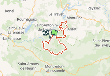
Randonnée Vélo électrique de 29 km à découvrir à Occitanie, Tarn, Terre-de-Bancalié. Cette randonnée est proposée par ktmetarn.

Description

La Roque ,coutounel,roc de pinté,arifat,salclas,capello,travanet,la Roque.

Profil altimétrique

Localisation

Pays :
France
Région :
Occitanie
Département/Province :
Tarn
Commune :
Terre-de-Bancalié
Localité :
Saint-Antonin-de-Lacalm
Départ:(Dec)
Départ:(UTM)
444951 ; 4846221 (31T) N.

Commentaires

Veuillez vous connecter pour laisser un commentaire ou une note


Randonnées à proximité

Randonnée Marche Montredon-Labessonnié - Sentier des agates revisité  - Photo
Marche
Isabelle Debrus

Marche

Facile
Montredon-Labessonnié, Occitanie, Tarn, France
14,4 km | 20 km-effort
3h 44min
Oui
Randonnée Marche Terre-de-Bancalié - Tour du lac de la bancalié - Photo
Marche
tiki01

Marche

Facile
Terre-de-Bancalié, Occitanie, Tarn, France
10,2 km | 12,4 km-effort
3h 3min
Oui
Randonnée Marche Arifat - cascades d'Arifat - Photo
Marche
jpipacific

Marche

Difficile
Arifat, Occitanie, Tarn, France
6 km | 9,1 km-effort
1h 58min
Oui
Randonnée Marche Terre-de-Bancalié - prepa fev - Photo
Marche
jpipacific

Marche

Facile
Terre-de-Bancalié, Occitanie, Tarn, France
6,4 km | 8,5 km-effort
1h 55min
Oui
Randonnée Marche Terre-de-Bancalié - le travet- traversee du Dadou - Photo
Marche
Frayssinet

Marche

Très difficile
(1)
Terre-de-Bancalié, Occitanie, Tarn, France
24 km | 36 km-effort
8h 9min
Oui
Randonnée Marche Arifat - 81_Arifat_longue_projet - Photo
Marche
jab31

Marche

Moyen
Arifat, Occitanie, Tarn, France
16,1 km | 24 km-effort
4h 20min
Oui
Randonnée Marche Montredon-Labessonnié - Arifat à Lagrifoul (Montredon Labessonie)  - Photo
Marche
Frayssinet

Marche

Moyen
Montredon-Labessonnié, Occitanie, Tarn, France
20 km | 30 km-effort
6h 4min
Oui
Randonnée Marche Arifat - 81_Arifat_Dadounet - Photo
Marche
jab31

Marche

Difficile
(1)
Arifat, Occitanie, Tarn, France
15,2 km | 23 km-effort
4h 57min
Oui
Randonnée Marche Mont-Roc - Rasisse Mont Roc - Photo
Marche
jpipacific

Marche

Moyen
Mont-Roc, Occitanie, Tarn, France
8,8 km | 12,8 km-effort
2h 32min
Oui


Fermer
Mes abonnements