Randonnée Cyclotourisme Norden - TDE63F NORDEN-EMDEN - Photo
 Bernard_FOURNIER
Bernard_FOURNIER

Utilisateur

© OpenStreetMap contributors
Longueur
Longueur
51 km
Altitude max
Altitude max
7 m
Dénivelé positif
Dénivelé positif
127 m
Km-Effort
Km-Effort  
53 km
Altitude min
Altitude min
-5 m
Dénivelé négatif
Dénivelé négatif
125 m
Boucle
Boucle
Non
Date de création :
2021-07-29 07:30:01.632
Dernière modification :
2021-07-29 15:58:18.373

(0 Avis)

Cyclotourisme
Cyclotourisme
4h55
Difficulté : Très difficile

Scannez ce code QR pour ouvrir la randonnée dans l'application SityTrail

Application GPS de randonnée GRATUITE

Logo SityTrail SityTrail

IGN / Instituts géographiques

Télécharger SityTrail sur l'App Store Télécharger SityTrail sur Google Play

Logo SityTrail SityTrail World

Le monde est à vous

Télécharger SityTrail sur l'App Store Télécharger SityTrail sur Google Play Télécharger SityTrail sur Huawei AppGallery

À propos

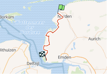
Randonnée Cyclotourisme de 51 km à découvrir à Basse-Saxe, Aurich (arrondissement), Norden. Cette randonnée est proposée par Bernard_FOURNIER.

Profil altimétrique

Localisation

Pays :
Allemagne
Région :
Basse-Saxe
Département/Province :
Aurich (arrondissement)
Commune :
Norden
Localité :
Westermarsch II
Départ:(UTM)
376875 ; 5941116 (32U) N.

Randonnées à proximité

Randonnée A pied Norderney - Dünen-Heller-Weg - Photo
A pied
PRO

A pied

Facile
Norderney, Basse-Saxe, Aurich (arrondissement), Allemagne
6,2 km | 6,3 km-effort
1h 25min
Non
Randonnée A pied Norderney - Promenadenrundweg - Photo
A pied
PRO

A pied

Facile
Norderney, Basse-Saxe, Aurich (arrondissement), Allemagne
6,5 km | 6,8 km-effort
1h 32min
Non
Randonnée A pied Norderney - Polder-Wattweg - Photo
A pied
PRO

A pied

Facile
Norderney, Basse-Saxe, Aurich (arrondissement), Allemagne
11,6 km | 11,9 km-effort
2h 42min
Non
Randonnée A pied Norderney - Leuchtturmrundweg - Photo
A pied
PRO

A pied

Facile
Norderney, Basse-Saxe, Aurich (arrondissement), Allemagne
9,5 km | 10 km-effort
2h 16min
Oui
Randonnée A pied Norderney - Thalasso-Plattform-Dünenweg - Photo
A pied
PRO

A pied

Facile
Norderney, Basse-Saxe, Aurich (arrondissement), Allemagne
6,6 km | 7 km-effort
1h 35min
Oui
Randonnée A pied Norderney - Südstrandpolderrunde - Photo
A pied
PRO

A pied

Facile
Norderney, Basse-Saxe, Aurich (arrondissement), Allemagne
5,3 km | 5,5 km-effort
1h 14min
Oui
Randonnée A pied Norderney - Naturparklauf - Photo
A pied
PRO

A pied

Facile
Norderney, Basse-Saxe, Aurich (arrondissement), Allemagne
8,8 km | 9,2 km-effort
2h 5min
Non
Randonnée A pied Juist - Rundweg Hammersee - Photo
A pied
PRO

A pied

Facile
Juist, Basse-Saxe, Aurich (arrondissement), Allemagne
3,4 km | 3,6 km-effort
48min
Oui
Randonnée Marche Wirdum - Duitsland - wandeling DvhN Wirdum (D) 13km - Photo
Marche
gpstracks

Marche

Très facile
Wirdum, Basse-Saxe, Aurich (arrondissement), Allemagne
14 km | 14,6 km-effort
Inconnu
Oui


Fermer
Mes abonnements