![](/images/other/stat-length.png)
![Randonnée Marche Beersel - Dworp/Sept-Fontaines/Colipain/bois de Halle/Dworp - Photo](https://media.geolcdn.com/t/1900/400/1884cf34-61dd-466e-a3a4-2f20b24a9866.jpg&format=pjpeg&maxdim=2)
Dworp/Sept-Fontaines/Colipain/bois de Halle/Dworp
Leemans
Utilisateur
![Longueur](/images/other/stat-length.png)
Longueur
14,2 km
![Altitude max](https://static1.geolcdn.com/siteimages/upload/files/1508320355ic_sort_altitude_max_24dp.png)
Altitude max
138 m
![Dénivelé positif](https://static1.geolcdn.com/siteimages/upload/files/1508320355ic_sort_den_pos_24dp.png)
Dénivelé positif
218 m
![Km-Effort](/images/other/stat-length.png)
Km-Effort
17,1 km
![Altitude min](https://static1.geolcdn.com/siteimages/upload/files/1508320355ic_sort_altitude_min_24dp.png)
Altitude min
40 m
![Dénivelé négatif](https://static1.geolcdn.com/siteimages/upload/files/1508320355ic_sort_den_neg_24dp.png)
Dénivelé négatif
217 m
![Boucle](https://static1.geolcdn.com/siteimages/upload/files/16400158638029165_repeat_loop_refresh_sync_direction_icon.png)
Boucle
Oui
Date de création :
2021-07-25 10:48:32.0
Dernière modification :
2021-07-25 15:48:38.766
![Marche](https://static1.geolcdn.com/sitytour/trail-icons/101.png)
2h53
Difficulté : Facile
![Scannez ce code QR pour ouvrir la randonnée dans l'application SityTrail](https://capi.geolives.com/qq0zvz2zws4bq2lad0pu/sitytour/trails/2873508/qr.png?size=200)
Application GPS de randonnée GRATUITE
À propos
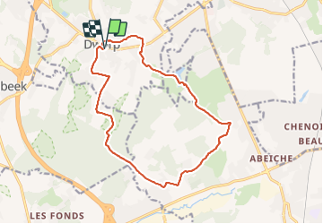
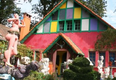
Randonnée Marche de 14,2 km à découvrir à Flandre, Brabant flamand, Beersel. Cette randonnée est proposée par Leemans.
Description
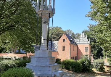
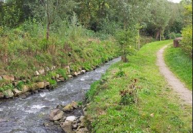
Départ de l'église de Dworp pour à 200m vers le nord rejoindre le GR 12 jusqu'au hameau de Colipain.
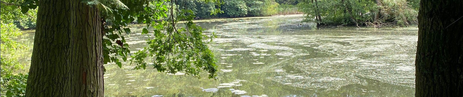
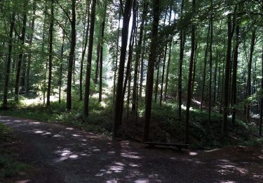
A Colipain, quitter le GR 12 pour retourner vers Dworp par le bois de Halle.
Localisation
Pays :
Belgique
Région :
Flandre
Département/Province :
Brabant flamand
Commune :
Beersel
Localité :
Tourneppe
Départ:(Dec)
Départ:(UTM)
591751 ; 5620559 (31U) N.
Commentaires
Randonnées à proximité
![Randonnée Marche Linkebeek - Linkebeek Perkhoeve en Peter Pan - 8 km RT - Photo](https://media.geolcdn.com/t/375/260/ext.jpg?maxdim=2&url=https%3A%2F%2Fstatic1.geolcdn.com%2Fsiteimages%2Fupload%2Ffiles%2F1553511878bg_sport_marche.png)
![Marche Marche](https://static1.geolcdn.com/sitytour/trail-icons/101.png)
Linkebeek Perkhoeve en Peter Pan - 8 km RT
Marche
Très facile
(5)
Linkebeek,
Flandre,
Brabant flamand,
Belgique
![](/images/other/stat-length.png)
7,6 km | 9,3 km-effort
Inconnu
![](https://static1.geolcdn.com/siteimages/upload/files/16400158638029165_repeat_loop_refresh_sync_direction_icon.png)
Oui
![Randonnée Marche Beersel - RL-GG-24_Beersel_Hennuyères - Photo](https://media.geolcdn.com/t/375/260/102ff410-776a-4c59-ae38-58c43777bc8a.jpg&format=jpg&maxdim=2)
![Marche Marche](https://static1.geolcdn.com/sitytour/trail-icons/101.png)
RL-GG-24_Beersel_Hennuyères
Marche
Moyen
(2)
Beersel,
Flandre,
Brabant flamand,
Belgique
![](/images/other/stat-length.png)
37 km | 47 km-effort
10h 44min
![](https://static1.geolcdn.com/siteimages/upload/files/16400158638029165_repeat_loop_refresh_sync_direction_icon.png)
Non
![Randonnée Marche Hal - Balade dans le Bois de Halle - Photo](https://media.geolcdn.com/t/375/260/ext.jpg?maxdim=2&url=https%3A%2F%2Fservices.sitytrail.com%2FGeolivesWS%2FDownloadMedia.ashx%3FTrailID%3D411974%26Media%3D4cfcce27-edaf-4211-9dbe-1277fff36f47.JPG)
![Marche Marche](https://static1.geolcdn.com/sitytour/trail-icons/101.png)
Balade dans le Bois de Halle
Marche
Facile
(2)
Hal,
Flandre,
Brabant flamand,
Belgique
![](/images/other/stat-length.png)
8,6 km | 10,5 km-effort
2h 14min
![](https://static1.geolcdn.com/siteimages/upload/files/16400158638029165_repeat_loop_refresh_sync_direction_icon.png)
Oui
![Randonnée Marche Beersel - Beersel 10km - Photo](https://media.geolcdn.com/t/375/260/4be021b0-0611-495b-8c11-6bedba66a35d.jpg&format=jpg&maxdim=2)
![Marche Marche](https://static1.geolcdn.com/sitytour/trail-icons/101.png)
Beersel 10km
Marche
Moyen
(2)
Beersel,
Flandre,
Brabant flamand,
Belgique
![](/images/other/stat-length.png)
10,5 km | 13,1 km-effort
2h 34min
![](https://static1.geolcdn.com/siteimages/upload/files/16400158638029165_repeat_loop_refresh_sync_direction_icon.png)
Oui
![Randonnée Marche Beersel - 2019-01-10 Boucle Huizingen 22 km - Photo](https://media.geolcdn.com/t/375/260/8543774e-ca92-454e-9fd7-9ac7878ef135.jpg&format=jpg&maxdim=2)
![Marche Marche](https://static1.geolcdn.com/sitytour/trail-icons/101.png)
2019-01-10 Boucle Huizingen 22 km
Marche
Très facile
(1)
Beersel,
Flandre,
Brabant flamand,
Belgique
![](/images/other/stat-length.png)
22 km | 27 km-effort
4h 38min
![](https://static1.geolcdn.com/siteimages/upload/files/16400158638029165_repeat_loop_refresh_sync_direction_icon.png)
Oui
![Randonnée Marche Braine-l'Alleud - Entre l'Ermite et Odeghien - Photo](https://media.geolcdn.com/t/375/260/ext.jpg?maxdim=2&url=https%3A%2F%2Fservices.sitytrail.com%2FGeolivesWS%2FDownloadMedia.ashx%3FTrailID%3D338686%26Media%3D20140824140258.jpg)
![Marche Marche](https://static1.geolcdn.com/sitytour/trail-icons/101.png)
Entre l'Ermite et Odeghien
Marche
Facile
(4)
Braine-l'Alleud,
Wallonie,
Brabant wallon,
Belgique
![](/images/other/stat-length.png)
7,2 km | 8,7 km-effort
1h 52min
![](https://static1.geolcdn.com/siteimages/upload/files/16400158638029165_repeat_loop_refresh_sync_direction_icon.png)
Non
![Randonnée Marche Beersel - Entre Beersel et Dworp - Photo](https://media.geolcdn.com/t/375/260/ext.jpg?maxdim=2&url=https%3A%2F%2Fservices.sitytrail.com%2FGeolivesWS%2FDownloadMedia.ashx%3FTrailID%3D310076%26Media%3D3efa6535-4846-4e23-9c11-65c16b69488b.jpg)
![Marche Marche](https://static1.geolcdn.com/sitytour/trail-icons/101.png)
Entre Beersel et Dworp
Marche
Moyen
(1)
Beersel,
Flandre,
Brabant flamand,
Belgique
![](/images/other/stat-length.png)
10,1 km | 13 km-effort
2h 45min
![](https://static1.geolcdn.com/siteimages/upload/files/16400158638029165_repeat_loop_refresh_sync_direction_icon.png)
Oui
![Randonnée Marche Beersel - Dworp Herisemmolen vers Elsemheide - Photo](https://media.geolcdn.com/t/375/260/ext.jpg?maxdim=2&url=https%3A%2F%2Fservices.sitytrail.com%2FGeolivesWS%2FDownloadMedia.ashx%3FTrailID%3D225257%26Media%3Dfix__20131004160100.jpg)
![Marche Marche](https://static1.geolcdn.com/sitytour/trail-icons/101.png)
Dworp Herisemmolen vers Elsemheide
Marche
Facile
(2)
Beersel,
Flandre,
Brabant flamand,
Belgique
![](/images/other/stat-length.png)
5,3 km | 6,4 km-effort
1h 26min
![](https://static1.geolcdn.com/siteimages/upload/files/16400158638029165_repeat_loop_refresh_sync_direction_icon.png)
Oui
![Randonnée Marche Hal - bois de halle hallerbos - Photo](https://media.geolcdn.com/t/375/260/171c7fd8-9c79-49a4-b4c2-e78fc47fb1c7.jpg&format=jpg&maxdim=2)
![Marche Marche](https://static1.geolcdn.com/sitytour/trail-icons/101.png)
bois de halle hallerbos
Marche
Très facile
(1)
Hal,
Flandre,
Brabant flamand,
Belgique
![](/images/other/stat-length.png)
7,1 km | 8,6 km-effort
1h 35min
![](https://static1.geolcdn.com/siteimages/upload/files/16400158638029165_repeat_loop_refresh_sync_direction_icon.png)
Oui