![](/images/other/stat-length.png)
![Randonnée Marche Hauteluce - Les Saisies - Croix de Coste - Photo](https://media.geolcdn.com/t/1900/400/ext.pjpeg?maxdim=2&url=https%3A%2F%2Fstatic1.geolcdn.com%2Fsiteimages%2Fupload%2Ffiles%2F1553511878bg_sport_marche.png)
Les Saisies - Croix de Coste
nicolas54230
Utilisateur
![Longueur](/images/other/stat-length.png)
![Altitude max](https://static1.geolcdn.com/siteimages/upload/files/1508320355ic_sort_altitude_max_24dp.png)
![Dénivelé positif](https://static1.geolcdn.com/siteimages/upload/files/1508320355ic_sort_den_pos_24dp.png)
![Km-Effort](/images/other/stat-length.png)
![Altitude min](https://static1.geolcdn.com/siteimages/upload/files/1508320355ic_sort_altitude_min_24dp.png)
![Dénivelé négatif](https://static1.geolcdn.com/siteimages/upload/files/1508320355ic_sort_den_neg_24dp.png)
![Boucle](https://static1.geolcdn.com/siteimages/upload/files/16400158638029165_repeat_loop_refresh_sync_direction_icon.png)
![Marche](https://static1.geolcdn.com/sitytour/trail-icons/101.png)
5h43
Difficulté : Très difficile
![Scannez ce code QR pour ouvrir la randonnée dans l'application SityTrail](https://capi.geolives.com/qq0zvz2zws4bq2lad0pu/sitytour/trails/2872253/qr.png?size=200)
Application GPS de randonnée GRATUITE
À propos
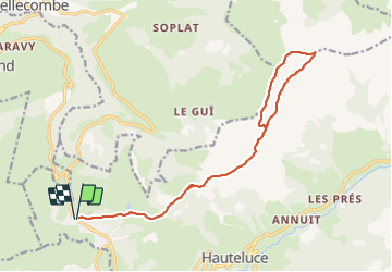
Randonnée Marche de 17,2 km à découvrir à Auvergne-Rhône-Alpes, Savoie, Hauteluce. Cette randonnée est proposée par nicolas54230.
Description
Départ : Des Saisies prendre la RD123 en direction de Bisanne 1500. Après avoir parcouru environ 2 km et dépassé les différentes résidences de tourisme, prendre la première route à droite. Remonter cette route étroite sur 800 m. Stationner au carrefour du chemin de l’alpage de Bisanne. Possibilité d’accéder également en navettes.
Du parking sous Bisanne prendre la direction de La Croix de Coste en passant par le chemin de l’Alpage de Bisanne. Au carrefour Bucheret continuer par le chemin en direction de La Croix de Coste. Arriver au carrefour du Lattaz du Vaz, continuer tout droit et suivre le chemin jusqu’à un petit collet. Prendre le sentier à gauche qui conduit à la Croix de Coste. Il est aussi possible de continuer sur la piste. Retour par le même itinéraire, ou possibilité de boucler par Le Planay.
Avant tout départ en randonnée, ballade ou activités en pleine nature, veillez à avoir pris connaissance les règles de sécurité et de bonne conduite !
Rendez vous sur http://www.erando.fr/index.php?id=regle-securite
Renseignements et contacts utiles
Numéro d'urgence européen : 112
Météo France: 0 892 68 02 73
Localisation
Commentaires
Randonnées à proximité
![Randonnée Marche Hauteluce - sous Bisanne au lac des Saisies - Photo](https://media.geolcdn.com/t/375/260/37326f22-0206-4f0e-b1e9-16790c9e91ab.jpg&format=jpg&maxdim=2)
![Marche Marche](https://static1.geolcdn.com/sitytour/trail-icons/101.png)
Marche
![](/images/other/stat-length.png)
![](https://static1.geolcdn.com/siteimages/upload/files/16400158638029165_repeat_loop_refresh_sync_direction_icon.png)
![Randonnée Vélo Villard-sur-Doron - Boucle Villars le Mont Crest Voland Les Saisies - Photo](https://media.geolcdn.com/t/375/260/ext.jpg?maxdim=2&url=https%3A%2F%2Fservices.sitytrail.com%2FGeolivesWS%2FDownloadMedia.ashx%3FTrailID%3D855162%26Media%3D20171031161248.jpg)
![Vélo Vélo](https://static1.geolcdn.com/sitytour/trail-icons/200.png)
Vélo
![](/images/other/stat-length.png)
![](https://static1.geolcdn.com/siteimages/upload/files/16400158638029165_repeat_loop_refresh_sync_direction_icon.png)
![Randonnée Marche Cohennoz - 2024-09-12 Marche Tour Beaufortain Gite Tete de Mule vers Gite Molliessoulaz - Photo](https://media.geolcdn.com/t/375/260/5a9a46b9-fe4c-4381-acb4-fc88d25b8d08.jpg&format=jpg&maxdim=2)
![Marche Marche](https://static1.geolcdn.com/sitytour/trail-icons/101.png)
Marche
![](/images/other/stat-length.png)
![](https://static1.geolcdn.com/siteimages/upload/files/16400158638029165_repeat_loop_refresh_sync_direction_icon.png)
![Randonnée V.T.T. Villard-sur-Doron - devalbertville - Photo](https://media.geolcdn.com/t/375/260/ext.jpg?maxdim=2&url=https%3A%2F%2Fstatic1.geolcdn.com%2Fsiteimages%2Fupload%2Ffiles%2F1524743154velo.jpg)
![V.T.T. V.T.T.](https://static1.geolcdn.com/sitytour/trail-icons/202.png)
V.T.T.
![](/images/other/stat-length.png)
![](https://static1.geolcdn.com/siteimages/upload/files/16400158638029165_repeat_loop_refresh_sync_direction_icon.png)
![Randonnée Marche Hauteluce - Hauteluce - Photo](https://media.geolcdn.com/t/375/260/ext.jpg?maxdim=2&url=https%3A%2F%2Fstatic1.geolcdn.com%2Fsiteimages%2Fupload%2Ffiles%2F1553511878bg_sport_marche.png)
![Marche Marche](https://static1.geolcdn.com/sitytour/trail-icons/101.png)
Marche
![](/images/other/stat-length.png)
![](https://static1.geolcdn.com/siteimages/upload/files/16400158638029165_repeat_loop_refresh_sync_direction_icon.png)
![Randonnée Marche Hauteluce - Mont Clocher - Photo](https://media.geolcdn.com/t/375/260/ext.jpg?maxdim=2&url=https%3A%2F%2Fservices.sitytrail.com%2FGeolivesWS%2FDownloadMedia.ashx%3FTrailID%3D85242%26Media%3D20110903163145.jpg)
![Marche Marche](https://static1.geolcdn.com/sitytour/trail-icons/101.png)
Marche
![](/images/other/stat-length.png)
![](https://static1.geolcdn.com/siteimages/upload/files/16400158638029165_repeat_loop_refresh_sync_direction_icon.png)
![Randonnée Marche Hauteluce - Croix de Coste - Mont Bisanne - Photo](https://media.geolcdn.com/t/375/260/6205cc33-0379-4e10-b69d-dfc0538206b7.jpg&format=jpg&maxdim=2)
![Marche Marche](https://static1.geolcdn.com/sitytour/trail-icons/101.png)
Marche
![](/images/other/stat-length.png)
![](https://static1.geolcdn.com/siteimages/upload/files/16400158638029165_repeat_loop_refresh_sync_direction_icon.png)
![Randonnée Raquettes à neige Hauteluce - Col des Saisies - Croix de la Coste - Signal de Bisanne - Photo](https://media.geolcdn.com/t/375/260/920def6e-b175-4f7b-a774-91a74da13156.jpg&format=jpg&maxdim=2)
![Raquettes à neige Raquettes à neige](https://static1.geolcdn.com/sitytour/trail-icons/504.png)
Raquettes à neige
![](/images/other/stat-length.png)
![](https://static1.geolcdn.com/siteimages/upload/files/16400158638029165_repeat_loop_refresh_sync_direction_icon.png)
![Randonnée Marche Hauteluce - Mont Clocher et Combe de la Douce - Photo](https://media.geolcdn.com/t/375/260/a2edfb01-eee9-45cf-8f65-75eca8a27771.jpg&format=jpg&maxdim=2)
![Marche Marche](https://static1.geolcdn.com/sitytour/trail-icons/101.png)
Marche
![](/images/other/stat-length.png)
![](https://static1.geolcdn.com/siteimages/upload/files/16400158638029165_repeat_loop_refresh_sync_direction_icon.png)