![](/images/other/stat-length.png)
![Randonnée Marche Freissinières - Vallon et lac du Fangeas/20/07/21 - Photo](https://media.geolcdn.com/t/1900/400/a7b98803-422a-42bb-95fd-4e0912cde832.jpg&format=pjpeg&maxdim=2)
Vallon et lac du Fangeas/20/07/21
Dervalmarc
Utilisateur
![Longueur](/images/other/stat-length.png)
Longueur
6 km
![Altitude max](https://static1.geolcdn.com/siteimages/upload/files/1508320355ic_sort_altitude_max_24dp.png)
Altitude max
1993 m
![Dénivelé positif](https://static1.geolcdn.com/siteimages/upload/files/1508320355ic_sort_den_pos_24dp.png)
Dénivelé positif
549 m
![Km-Effort](/images/other/stat-length.png)
Km-Effort
13,3 km
![Altitude min](https://static1.geolcdn.com/siteimages/upload/files/1508320355ic_sort_altitude_min_24dp.png)
Altitude min
1439 m
![Dénivelé négatif](https://static1.geolcdn.com/siteimages/upload/files/1508320355ic_sort_den_neg_24dp.png)
Dénivelé négatif
550 m
![Boucle](https://static1.geolcdn.com/siteimages/upload/files/16400158638029165_repeat_loop_refresh_sync_direction_icon.png)
Boucle
Oui
Date de création :
2021-07-20 08:45:03.033
Dernière modification :
2021-07-20 17:43:20.113
![Marche](https://static1.geolcdn.com/sitytour/trail-icons/101.png)
5h25
Difficulté : Facile
![Scannez ce code QR pour ouvrir la randonnée dans l'application SityTrail](https://capi.geolives.com/qq0zvz2zws4bq2lad0pu/sitytour/trails/2868060/qr.png?size=200)
Application GPS de randonnée GRATUITE
À propos
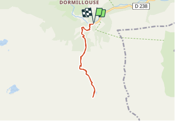
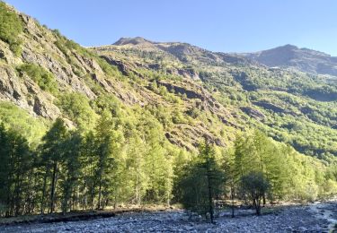
Randonnée Marche de 6 km à découvrir à Provence-Alpes-Côte d'Azur, Hautes-Alpes, Freissinières. Cette randonnée est proposée par Dervalmarc.
Description
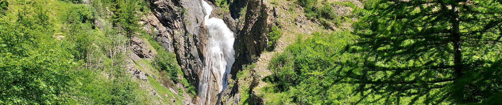
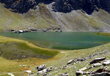
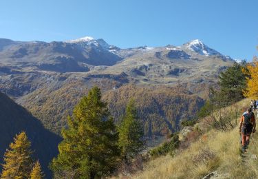
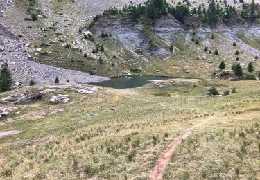
Randonnée agréable au cœur du Parc national des Écrins.
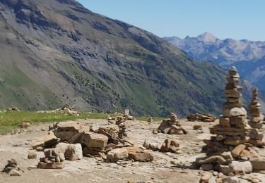
A éviter entre le 15/07 et le 15/08.
En raison d'une fort affluence.
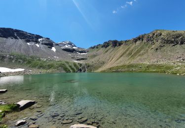
Rando familial par excellence.
Très grande richesse botanique
Compter 3 heures aller retour
Localisation
Pays :
France
Région :
Provence-Alpes-Côte d'Azur
Département/Province :
Hautes-Alpes
Commune :
Freissinières
Localité :
Unknown
Départ:(Dec)
Départ:(UTM)
298050 ; 4956499 (32T) N.
Commentaires
Randonnées à proximité
![Randonnée Marche Freissinières - les 3 lacs : Palluel, Faravel et Fangeas + montée grand Pinier - Photo](https://media.geolcdn.com/t/375/260/ext.jpg?maxdim=2&url=https%3A%2F%2Fservices.sitytrail.com%2FGeolivesWS%2FDownloadMedia.ashx%3FTrailID%3D213821%26Media%3Dfix__20130816161219.jpg)
![Marche Marche](https://static1.geolcdn.com/sitytour/trail-icons/101.png)
les 3 lacs : Palluel, Faravel et Fangeas + montée grand Pinier
Marche
Moyen
(2)
Freissinières,
Provence-Alpes-Côte d'Azur,
Hautes-Alpes,
France
![](/images/other/stat-length.png)
23 km | 47 km-effort
9h 0min
![](https://static1.geolcdn.com/siteimages/upload/files/16400158638029165_repeat_loop_refresh_sync_direction_icon.png)
Oui
![Randonnée Marche Freissinières - 2020-09-08 Marche Dormillouse Lacs Palluel Faravel Fangeas - Photo](https://media.geolcdn.com/t/375/260/21169251-c2dd-4994-a63e-6ea6e20b7955.jpg&format=jpg&maxdim=2)
![Marche Marche](https://static1.geolcdn.com/sitytour/trail-icons/101.png)
2020-09-08 Marche Dormillouse Lacs Palluel Faravel Fangeas
Marche
Moyen
Freissinières,
Provence-Alpes-Côte d'Azur,
Hautes-Alpes,
France
![](/images/other/stat-length.png)
16,1 km | 31 km-effort
5h 57min
![](https://static1.geolcdn.com/siteimages/upload/files/16400158638029165_repeat_loop_refresh_sync_direction_icon.png)
Oui
![Randonnée Marche Freissinières - Trois lacs de Dormillouse - Photo](https://media.geolcdn.com/t/375/260/ext.jpg?maxdim=2&url=https%3A%2F%2Fstatic1.geolcdn.com%2Fsiteimages%2Fupload%2Ffiles%2F1553511878bg_sport_marche.png)
![Marche Marche](https://static1.geolcdn.com/sitytour/trail-icons/101.png)
Trois lacs de Dormillouse
Marche
Moyen
(1)
Freissinières,
Provence-Alpes-Côte d'Azur,
Hautes-Alpes,
France
![](/images/other/stat-length.png)
16,3 km | 30 km-effort
6h 28min
![](https://static1.geolcdn.com/siteimages/upload/files/16400158638029165_repeat_loop_refresh_sync_direction_icon.png)
Oui
![Randonnée Marche Freissinières - les Violins Dormillouse - Photo](https://media.geolcdn.com/t/375/260/46ae824a-5fe7-4309-8011-b209a71cff0c.jpg&format=jpg&maxdim=2)
![Marche Marche](https://static1.geolcdn.com/sitytour/trail-icons/101.png)
les Violins Dormillouse
Marche
Facile
Freissinières,
Provence-Alpes-Côte d'Azur,
Hautes-Alpes,
France
![](/images/other/stat-length.png)
14,8 km | 28 km-effort
9h 14min
![](https://static1.geolcdn.com/siteimages/upload/files/16400158638029165_repeat_loop_refresh_sync_direction_icon.png)
Oui
![Randonnée Marche Freissinières - 05-Dormillouse-lac-Fangeas-pont-fer-11km740m - Photo](https://media.geolcdn.com/t/375/260/c1871a11-c31f-42d4-be0b-750e43234795.jpg&format=jpg&maxdim=2)
![Marche Marche](https://static1.geolcdn.com/sitytour/trail-icons/101.png)
05-Dormillouse-lac-Fangeas-pont-fer-11km740m
Marche
Moyen
Freissinières,
Provence-Alpes-Côte d'Azur,
Hautes-Alpes,
France
![](/images/other/stat-length.png)
11 km | 21 km-effort
5h 25min
![](https://static1.geolcdn.com/siteimages/upload/files/16400158638029165_repeat_loop_refresh_sync_direction_icon.png)
Oui
![Randonnée Marche Freissinières - Les 3 lacs. Paluel Faravel Frangeas - Photo](https://media.geolcdn.com/t/375/260/41aececb-5518-4303-876a-61d5e49e0b6f.jpg&format=jpg&maxdim=2)
![Marche Marche](https://static1.geolcdn.com/sitytour/trail-icons/101.png)
Les 3 lacs. Paluel Faravel Frangeas
Marche
Difficile
Freissinières,
Provence-Alpes-Côte d'Azur,
Hautes-Alpes,
France
![](/images/other/stat-length.png)
15 km | 29 km-effort
7h 21min
![](https://static1.geolcdn.com/siteimages/upload/files/16400158638029165_repeat_loop_refresh_sync_direction_icon.png)
Oui
![Randonnée Marche Freissinières - parking des cascades, lac de Palluel, lac de Fara vel retour par Dormillouse et le sentier d'hiver - Photo](https://media.geolcdn.com/t/375/260/174f3a1c-2604-4fc5-8be1-97bab62364c4.jpg&format=jpg&maxdim=2)
![Marche Marche](https://static1.geolcdn.com/sitytour/trail-icons/101.png)
parking des cascades, lac de Palluel, lac de Fara vel retour par Dormillouse ...
Marche
Très difficile
Freissinières,
Provence-Alpes-Côte d'Azur,
Hautes-Alpes,
France
![](/images/other/stat-length.png)
15,7 km | 31 km-effort
8h 1min
![](https://static1.geolcdn.com/siteimages/upload/files/16400158638029165_repeat_loop_refresh_sync_direction_icon.png)
Oui
![Randonnée Marche Freissinières - lacs de Fangeas , Faravel et palluel - Photo](https://media.geolcdn.com/t/375/260/ccff4a91-af95-46da-b421-edaea0f00f03.jpg&format=jpg&maxdim=2)
![Marche Marche](https://static1.geolcdn.com/sitytour/trail-icons/101.png)
lacs de Fangeas , Faravel et palluel
Marche
Moyen
Freissinières,
Provence-Alpes-Côte d'Azur,
Hautes-Alpes,
France
![](/images/other/stat-length.png)
15,8 km | 30 km-effort
7h 37min
![](https://static1.geolcdn.com/siteimages/upload/files/16400158638029165_repeat_loop_refresh_sync_direction_icon.png)
Oui
![Randonnée Marche Freissinières - fangeas - Photo](https://media.geolcdn.com/t/375/260/ext.jpg?maxdim=2&url=https%3A%2F%2Fstatic1.geolcdn.com%2Fsiteimages%2Fupload%2Ffiles%2F1553511878bg_sport_marche.png)
![Marche Marche](https://static1.geolcdn.com/sitytour/trail-icons/101.png)
fangeas
Marche
Très facile
(1)
Freissinières,
Provence-Alpes-Côte d'Azur,
Hautes-Alpes,
France
![](/images/other/stat-length.png)
7,7 km | 15,1 km-effort
5h 19min
![](https://static1.geolcdn.com/siteimages/upload/files/16400158638029165_repeat_loop_refresh_sync_direction_icon.png)
Oui