![](/images/other/stat-length.png)
![Randonnée Marche Château-Landon - Promenade à Château Landon et ses alentours - Photo](https://media.geolcdn.com/t/1900/400/244bb424-b741-4ba6-890d-87f3dc9ec396.jpg&format=pjpeg&maxdim=2)
Promenade à Château Landon et ses alentours
chessyca
Utilisateur GUIDE
![Longueur](/images/other/stat-length.png)
Longueur
12,7 km
![Altitude max](https://static1.geolcdn.com/siteimages/upload/files/1508320355ic_sort_altitude_max_24dp.png)
Altitude max
104 m
![Dénivelé positif](https://static1.geolcdn.com/siteimages/upload/files/1508320355ic_sort_den_pos_24dp.png)
Dénivelé positif
183 m
![Km-Effort](/images/other/stat-length.png)
Km-Effort
15,1 km
![Altitude min](https://static1.geolcdn.com/siteimages/upload/files/1508320355ic_sort_altitude_min_24dp.png)
Altitude min
66 m
![Dénivelé négatif](https://static1.geolcdn.com/siteimages/upload/files/1508320355ic_sort_den_neg_24dp.png)
Dénivelé négatif
184 m
![Boucle](https://static1.geolcdn.com/siteimages/upload/files/16400158638029165_repeat_loop_refresh_sync_direction_icon.png)
Boucle
Oui
Date de création :
2021-07-20 08:51:00.174
Dernière modification :
2021-07-20 18:29:30.722
![Marche](https://static1.geolcdn.com/sitytour/trail-icons/101.png)
2h50
Difficulté : Très facile
![Scannez ce code QR pour ouvrir la randonnée dans l'application SityTrail](https://capi.geolives.com/qq0zvz2zws4bq2lad0pu/sitytour/trails/2867991/qr.png?size=200)
Application GPS de randonnée GRATUITE
À propos
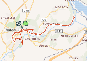
Randonnée Marche de 12,7 km à découvrir à Île-de-France, Seine-et-Marne, Château-Landon. Cette randonnée est proposée par chessyca.
Description
Découverte de cette pittoresque cité de Seine et Marne et de son parc. Puis petit parcours jusqu'au village voisin pour découvrir le Pont Canal
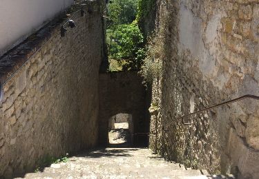
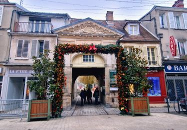
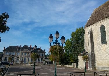
Localisation
Pays :
France
Région :
Île-de-France
Département/Province :
Seine-et-Marne
Commune :
Château-Landon
Localité :
Unknown
Départ:(Dec)
Départ:(UTM)
478007 ; 5333088 (31U) N.
Commentaires
Randonnées à proximité
![Randonnée Marche Souppes-sur-Loing - Soupe sur Loing Chateau Landon en 8 - Photo](https://media.geolcdn.com/t/375/260/ext.jpg?maxdim=2&url=https%3A%2F%2Fservices.sitytrail.com%2FGeolivesWS%2FDownloadMedia.ashx%3FTrailID%3D790644%26Media%3D20170716134421.jpg)
![Marche Marche](https://static1.geolcdn.com/sitytour/trail-icons/101.png)
Soupe sur Loing Chateau Landon en 8
Marche
Facile
(1)
Souppes-sur-Loing,
Île-de-France,
Seine-et-Marne,
France
![](/images/other/stat-length.png)
21 km | 24 km-effort
4h 55min
![](https://static1.geolcdn.com/siteimages/upload/files/16400158638029165_repeat_loop_refresh_sync_direction_icon.png)
Oui
![Randonnée Marche Château-Landon - Linéaire de Chateau Landon à Nemours - Photo](https://media.geolcdn.com/t/375/260/8753eae8-2f26-4943-87f7-54ddecdce294.jpg&format=jpg&maxdim=2)
![Marche Marche](https://static1.geolcdn.com/sitytour/trail-icons/101.png)
Linéaire de Chateau Landon à Nemours
Marche
Difficile
Château-Landon,
Île-de-France,
Seine-et-Marne,
France
![](/images/other/stat-length.png)
32 km | 37 km-effort
6h 49min
![](https://static1.geolcdn.com/siteimages/upload/files/16400158638029165_repeat_loop_refresh_sync_direction_icon.png)
Non
![Randonnée Marche Château-Landon - De Château Landon à Nemours - Photo](https://media.geolcdn.com/t/375/260/7994ec5b-0bd1-4371-b464-9311cc61e5ca.jpg&format=jpg&maxdim=2)
![Marche Marche](https://static1.geolcdn.com/sitytour/trail-icons/101.png)
De Château Landon à Nemours
Marche
Moyen
Château-Landon,
Île-de-France,
Seine-et-Marne,
France
![](/images/other/stat-length.png)
32 km | 37 km-effort
6h 59min
![](https://static1.geolcdn.com/siteimages/upload/files/16400158638029165_repeat_loop_refresh_sync_direction_icon.png)
Non
![Randonnée Marche Souppes-sur-Loing - Autour de Château Landon - Photo](https://media.geolcdn.com/t/375/260/ext.jpg?maxdim=2&url=https%3A%2F%2Fstatic1.geolcdn.com%2Fsiteimages%2Fupload%2Ffiles%2F1553511878bg_sport_marche.png)
![Marche Marche](https://static1.geolcdn.com/sitytour/trail-icons/101.png)
Autour de Château Landon
Marche
Très difficile
(1)
Souppes-sur-Loing,
Île-de-France,
Seine-et-Marne,
France
![](/images/other/stat-length.png)
17,1 km | 20 km-effort
4h 33min
![](https://static1.geolcdn.com/siteimages/upload/files/16400158638029165_repeat_loop_refresh_sync_direction_icon.png)
Oui
![Randonnée sport Souppes-sur-Loing - Château Landon es et ff - Photo](https://media.geolcdn.com/t/375/260/af2ba421-5186-4be2-b439-a1eb87adf51e.jpg&format=jpg&maxdim=2)
Château Landon es et ff
sport
Très facile
Souppes-sur-Loing,
Île-de-France,
Seine-et-Marne,
France
![](/images/other/stat-length.png)
20 km | 23 km-effort
Inconnu
![](https://static1.geolcdn.com/siteimages/upload/files/16400158638029165_repeat_loop_refresh_sync_direction_icon.png)
Non
![Randonnée Autre activité Souppes-sur-Loing - Souppes - Photo](https://media.geolcdn.com/t/375/260/ext.jpg?maxdim=2&url=https%3A%2F%2Fservices.sitytrail.com%2FGeolivesWS%2FDownloadMedia.ashx%3FTrailID%3D840317%26Media%3Dfix__20171004104634.jpg)
![Autre activité Autre activité](https://static1.geolcdn.com/sitytour/trail-icons/900.png)
Souppes
Autre activité
Très facile
Souppes-sur-Loing,
Île-de-France,
Seine-et-Marne,
France
![](/images/other/stat-length.png)
21 km | 24 km-effort
5h 0min
![](https://static1.geolcdn.com/siteimages/upload/files/16400158638029165_repeat_loop_refresh_sync_direction_icon.png)
Oui
![Randonnée Vélo de route Château-Landon - Château landon à cepoy - Photo](https://media.geolcdn.com/t/375/260/ext.jpg?maxdim=2&url=https%3A%2F%2Fstatic1.geolcdn.com%2Fsiteimages%2Fupload%2Ffiles%2F1524743154velo.jpg)
![Vélo de route Vélo de route](https://static1.geolcdn.com/sitytour/trail-icons/201.png)
Château landon à cepoy
Vélo de route
Difficile
Château-Landon,
Île-de-France,
Seine-et-Marne,
France
![](/images/other/stat-length.png)
35 km | 39 km-effort
2h 48min
![](https://static1.geolcdn.com/siteimages/upload/files/16400158638029165_repeat_loop_refresh_sync_direction_icon.png)
Oui
![Randonnée Vélo de route Souppes-sur-Loing - Soupped - Photo](https://media.geolcdn.com/t/375/260/ext.jpg?maxdim=2&url=https%3A%2F%2Fstatic1.geolcdn.com%2Fsiteimages%2Fupload%2Ffiles%2F1524743154velo.jpg)
![Vélo de route Vélo de route](https://static1.geolcdn.com/sitytour/trail-icons/201.png)
Soupped
Vélo de route
Facile
Souppes-sur-Loing,
Île-de-France,
Seine-et-Marne,
France
![](/images/other/stat-length.png)
49 km | 54 km-effort
4h 2min
![](https://static1.geolcdn.com/siteimages/upload/files/16400158638029165_repeat_loop_refresh_sync_direction_icon.png)
Oui
![Randonnée Marche Dordives - Dordives - Photo](https://media.geolcdn.com/t/375/260/ext.jpg?maxdim=2&url=https%3A%2F%2Fstatic1.geolcdn.com%2Fsiteimages%2Fupload%2Ffiles%2F1553511878bg_sport_marche.png)
![Marche Marche](https://static1.geolcdn.com/sitytour/trail-icons/101.png)
Dordives
Marche
Très difficile
Dordives,
Centre-Val de Loire,
Loiret,
France
![](/images/other/stat-length.png)
23 km | 27 km-effort
6h 4min
![](https://static1.geolcdn.com/siteimages/upload/files/16400158638029165_repeat_loop_refresh_sync_direction_icon.png)
Oui