![](/images/other/stat-length.png)
![Randonnée Marche Tignes - Barrage delà sassiere - Photo](https://media.geolcdn.com/t/1900/400/58560baf-aebc-4095-8795-8d99e555e9ae.jpg&format=pjpeg&maxdim=2)
Barrage delà sassiere
perrierf
Utilisateur
![Longueur](/images/other/stat-length.png)
Longueur
7,3 km
![Altitude max](https://static1.geolcdn.com/siteimages/upload/files/1508320355ic_sort_altitude_max_24dp.png)
Altitude max
2473 m
![Dénivelé positif](https://static1.geolcdn.com/siteimages/upload/files/1508320355ic_sort_den_pos_24dp.png)
Dénivelé positif
206 m
![Km-Effort](/images/other/stat-length.png)
Km-Effort
10 km
![Altitude min](https://static1.geolcdn.com/siteimages/upload/files/1508320355ic_sort_altitude_min_24dp.png)
Altitude min
2278 m
![Dénivelé négatif](https://static1.geolcdn.com/siteimages/upload/files/1508320355ic_sort_den_neg_24dp.png)
Dénivelé négatif
210 m
![Boucle](https://static1.geolcdn.com/siteimages/upload/files/16400158638029165_repeat_loop_refresh_sync_direction_icon.png)
Boucle
Oui
Date de création :
2021-07-14 14:21:52.0
Dernière modification :
2021-07-14 15:57:57.025
![Marche](https://static1.geolcdn.com/sitytour/trail-icons/101.png)
1h34
Difficulté :
![Scannez ce code QR pour ouvrir la randonnée dans l'application SityTrail](https://capi.geolives.com/qq0zvz2zws4bq2lad0pu/sitytour/trails/2860855/qr.png?size=200)
Application GPS de randonnée GRATUITE
À propos
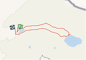
Randonnée Marche de 7,3 km à découvrir à Auvergne-Rhône-Alpes, Savoie, Tignes. Cette randonnée est proposée par perrierf.
Description
Boucle avec à aller : chemin large et avec beaucoup de marmottes et bouquetins.
Après la retenue d’eau : sentier monotrace pour revenir sur le parking.
Localisation
Pays :
France
Région :
Auvergne-Rhône-Alpes
Département/Province :
Savoie
Commune :
Tignes
Localité :
Unknown
Départ:(Dec)
Départ:(UTM)
341243 ; 5039027 (32T) N.
Commentaires
Randonnées à proximité
![Randonnée Marche Val-d'Isère - rocher du Charvet - Photo](https://media.geolcdn.com/t/375/260/695e5e9f-e8dc-4cf9-b576-ab38f18a42af.jpg&format=jpg&maxdim=2)
![Marche Marche](https://static1.geolcdn.com/sitytour/trail-icons/101.png)
rocher du Charvet
Marche
Difficile
(1)
Val-d'Isère,
Auvergne-Rhône-Alpes,
Savoie,
France
![](/images/other/stat-length.png)
12,6 km | 20 km-effort
5h 10min
![](https://static1.geolcdn.com/siteimages/upload/files/16400158638029165_repeat_loop_refresh_sync_direction_icon.png)
Non
![Randonnée Marche Tignes - la pointe de Picheru - Photo](https://media.geolcdn.com/t/375/260/ext.jpg?maxdim=2&url=https%3A%2F%2Fservices.sitytrail.com%2FGeolivesWS%2FDownloadMedia.ashx%3FTrailID%3D813856%26Media%3Dfix__20170820100255.jpg)
![Marche Marche](https://static1.geolcdn.com/sitytour/trail-icons/101.png)
la pointe de Picheru
Marche
Moyen
(1)
Tignes,
Auvergne-Rhône-Alpes,
Savoie,
France
![](/images/other/stat-length.png)
13,8 km | 23 km-effort
5h 36min
![](https://static1.geolcdn.com/siteimages/upload/files/16400158638029165_repeat_loop_refresh_sync_direction_icon.png)
Oui
![Randonnée Marche Tignes - lacs du saut et de la sassiere - Photo](https://media.geolcdn.com/t/375/260/ext.jpg?maxdim=2&url=https%3A%2F%2Fservices.sitytrail.com%2FGeolivesWS%2FDownloadMedia.ashx%3FTrailID%3D336967%26Media%3D637041f5-cff1-4406-a972-10b75ef104dd.JPG)
![Marche Marche](https://static1.geolcdn.com/sitytour/trail-icons/101.png)
lacs du saut et de la sassiere
Marche
Très facile
(3)
Tignes,
Auvergne-Rhône-Alpes,
Savoie,
France
![](/images/other/stat-length.png)
9 km | 12,6 km-effort
3h 56min
![](https://static1.geolcdn.com/siteimages/upload/files/16400158638029165_repeat_loop_refresh_sync_direction_icon.png)
Oui
![Randonnée Marche Tignes - Tignes 1800 lac de la Sassièrre aller-retour - Photo](https://media.geolcdn.com/t/375/260/ae37ca96-9517-4fd4-82f6-2f8c10f3622c.jpg&format=jpg&maxdim=2)
![Marche Marche](https://static1.geolcdn.com/sitytour/trail-icons/101.png)
Tignes 1800 lac de la Sassièrre aller-retour
Marche
Moyen
(1)
Tignes,
Auvergne-Rhône-Alpes,
Savoie,
France
![](/images/other/stat-length.png)
28 km | 47 km-effort
1h 0min
![](https://static1.geolcdn.com/siteimages/upload/files/16400158638029165_repeat_loop_refresh_sync_direction_icon.png)
Oui
![Randonnée Marche Tignes - boucle Tignes le lac - la daille - Photo](https://media.geolcdn.com/t/375/260/ext.jpg?maxdim=2&url=https%3A%2F%2Fservices.sitytrail.com%2FGeolivesWS%2FDownloadMedia.ashx%3FTrailID%3D132978%26Media%3D20120609144529.jpg)
![Marche Marche](https://static1.geolcdn.com/sitytour/trail-icons/101.png)
boucle Tignes le lac - la daille
Marche
Facile
(1)
Tignes,
Auvergne-Rhône-Alpes,
Savoie,
France
![](/images/other/stat-length.png)
14 km | 23 km-effort
2h 56min
![](https://static1.geolcdn.com/siteimages/upload/files/16400158638029165_repeat_loop_refresh_sync_direction_icon.png)
Oui
![Randonnée Marche Val-d'Isère - Les cascades des salins au départ de val d’Isère - Photo](https://media.geolcdn.com/t/375/260/c3b76218-f72c-4eeb-8155-41f32eab8f13.jpg&format=jpg&maxdim=2)
![Marche Marche](https://static1.geolcdn.com/sitytour/trail-icons/101.png)
Les cascades des salins au départ de val d’Isère
Marche
Moyen
(1)
Val-d'Isère,
Auvergne-Rhône-Alpes,
Savoie,
France
![](/images/other/stat-length.png)
9,5 km | 15,2 km-effort
3h 40min
![](https://static1.geolcdn.com/siteimages/upload/files/16400158638029165_repeat_loop_refresh_sync_direction_icon.png)
Oui
![Randonnée Marche Tignes - Refuge de la Martin - Photo](https://media.geolcdn.com/t/375/260/ext.jpg?maxdim=2&url=https%3A%2F%2Fservices.sitytrail.com%2FGeolivesWS%2FDownloadMedia.ashx%3FTrailID%3D853550%26Media%3Dfix__20171025152818.jpg)
![Marche Marche](https://static1.geolcdn.com/sitytour/trail-icons/101.png)
Refuge de la Martin
Marche
Moyen
(1)
Tignes,
Auvergne-Rhône-Alpes,
Savoie,
France
![](/images/other/stat-length.png)
13,3 km | 26 km-effort
6h 4min
![](https://static1.geolcdn.com/siteimages/upload/files/16400158638029165_repeat_loop_refresh_sync_direction_icon.png)
Oui
![Randonnée Marche Tignes - approche glacière de la cime de la Golette - Photo](https://media.geolcdn.com/t/375/260/72e50cb0-5647-449b-b1a2-a84fe5e68f8a.jpg&format=jpg&maxdim=2)
![Marche Marche](https://static1.geolcdn.com/sitytour/trail-icons/101.png)
approche glacière de la cime de la Golette
Marche
Très difficile
Tignes,
Auvergne-Rhône-Alpes,
Savoie,
France
![](/images/other/stat-length.png)
18,5 km | 32 km-effort
8h 29min
![](https://static1.geolcdn.com/siteimages/upload/files/16400158638029165_repeat_loop_refresh_sync_direction_icon.png)
Oui
![Randonnée Marche Val-d'Isère - Lac, col et pointe de la Bailletaz - Photo](https://media.geolcdn.com/t/375/260/9d40bc9e-390f-4a5e-a6f3-053ea09f211b.jpg&format=jpg&maxdim=2)
![Marche Marche](https://static1.geolcdn.com/sitytour/trail-icons/101.png)
Lac, col et pointe de la Bailletaz
Marche
Difficile
Val-d'Isère,
Auvergne-Rhône-Alpes,
Savoie,
France
![](/images/other/stat-length.png)
9,6 km | 23 km-effort
4h 35min
![](https://static1.geolcdn.com/siteimages/upload/files/16400158638029165_repeat_loop_refresh_sync_direction_icon.png)
Oui