![](/images/other/stat-length.png)
![Randonnée Cyclotourisme Pineuilh - 008 ste foy to la reole - Photo](https://media.geolcdn.com/t/1900/400/ext.pjpeg?maxdim=2&url=https%3A%2F%2Fstatic1.geolcdn.com%2Fsiteimages%2Fupload%2Ffiles%2F1524743154velo.jpg)
008 ste foy to la reole
Piper.Classique
Utilisateur
![Longueur](/images/other/stat-length.png)
Longueur
48 km
![Altitude max](https://static1.geolcdn.com/siteimages/upload/files/1508320355ic_sort_altitude_max_24dp.png)
Altitude max
121 m
![Dénivelé positif](https://static1.geolcdn.com/siteimages/upload/files/1508320355ic_sort_den_pos_24dp.png)
Dénivelé positif
666 m
![Km-Effort](/images/other/stat-length.png)
Km-Effort
57 km
![Altitude min](https://static1.geolcdn.com/siteimages/upload/files/1508320355ic_sort_altitude_min_24dp.png)
Altitude min
10 m
![Dénivelé négatif](https://static1.geolcdn.com/siteimages/upload/files/1508320355ic_sort_den_neg_24dp.png)
Dénivelé négatif
669 m
![Boucle](https://static1.geolcdn.com/siteimages/upload/files/16400158638029165_repeat_loop_refresh_sync_direction_icon.png)
Boucle
Non
Date de création :
2021-07-13 09:42:03.549
Dernière modification :
2021-07-15 15:52:43.202
![Cyclotourisme](https://static1.geolcdn.com/sitytour/trail-icons/204.png)
--
Difficulté : Inconnu
![Scannez ce code QR pour ouvrir la randonnée dans l'application SityTrail](https://capi.geolives.com/qq0zvz2zws4bq2lad0pu/sitytour/trails/2859278/qr.png?size=200)
Application GPS de randonnée GRATUITE
À propos
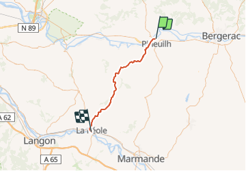
Randonnée Cyclotourisme de 48 km à découvrir à Nouvelle-Aquitaine, Gironde, Pineuilh. Cette randonnée est proposée par Piper.Classique.
Description
There is some gravel shortly after Coutures. You can avoid this by continuing on the D15 to the next major crossroads then turning left onto the D126E3
Localisation
Pays :
France
Région :
Nouvelle-Aquitaine
Département/Province :
Gironde
Commune :
Pineuilh
Localité :
Unknown
Départ:(Dec)
Départ:(UTM)
280668 ; 4969383 (31T) N.
Commentaires
Randonnées à proximité
![Randonnée A pied Le Fleix - Boucle de Gabastou - Photo](https://media.geolcdn.com/t/375/260/18d814c7-f45f-471d-9961-e2b02014db18.jpeg&format=jpg&maxdim=2)
![A pied A pied](https://static1.geolcdn.com/sitytour/trail-icons/100.png)
Boucle de Gabastou
A pied
Facile
Le Fleix,
Nouvelle-Aquitaine,
Dordogne,
France
![](/images/other/stat-length.png)
8,4 km | 10 km-effort
2h 16min
![](https://static1.geolcdn.com/siteimages/upload/files/16400158638029165_repeat_loop_refresh_sync_direction_icon.png)
Non
![Randonnée A pied Le Fleix - Boucle de Cap de fer - Photo](https://media.geolcdn.com/t/375/260/86475a03-e544-4a11-b09f-95948087b74f.jpeg&format=jpg&maxdim=2)
![A pied A pied](https://static1.geolcdn.com/sitytour/trail-icons/100.png)
Boucle de Cap de fer
A pied
Facile
Le Fleix,
Nouvelle-Aquitaine,
Dordogne,
France
![](/images/other/stat-length.png)
5,7 km | 7,7 km-effort
1h 45min
![](https://static1.geolcdn.com/siteimages/upload/files/16400158638029165_repeat_loop_refresh_sync_direction_icon.png)
Non
![Randonnée Marche Le Fleix - le sac, les cèdres, st avit - Photo](https://media.geolcdn.com/t/375/260/ext.jpg?maxdim=2&url=https%3A%2F%2Fstatic1.geolcdn.com%2Fsiteimages%2Fupload%2Ffiles%2F1553511878bg_sport_marche.png)
![Marche Marche](https://static1.geolcdn.com/sitytour/trail-icons/101.png)
le sac, les cèdres, st avit
Marche
Facile
Le Fleix,
Nouvelle-Aquitaine,
Dordogne,
France
![](/images/other/stat-length.png)
10,4 km | 11,3 km-effort
3h 30min
![](https://static1.geolcdn.com/siteimages/upload/files/16400158638029165_repeat_loop_refresh_sync_direction_icon.png)
Oui
![Randonnée V.T.T. Pineuilh - 9 Sainte Foy la Grande-Bazas-St Jacques de Compostelle - Photo](https://media.geolcdn.com/t/375/260/ext.jpg?maxdim=2&url=https%3A%2F%2Fstatic1.geolcdn.com%2Fsiteimages%2Fupload%2Ffiles%2F1524743154velo.jpg)
![V.T.T. V.T.T.](https://static1.geolcdn.com/sitytour/trail-icons/202.png)
9 Sainte Foy la Grande-Bazas-St Jacques de Compostelle
V.T.T.
Difficile
Pineuilh,
Nouvelle-Aquitaine,
Gironde,
France
![](/images/other/stat-length.png)
99 km | 119 km-effort
7h 38min
![](https://static1.geolcdn.com/siteimages/upload/files/16400158638029165_repeat_loop_refresh_sync_direction_icon.png)
Non
![Randonnée Marche Le Fleix - moulins et rivière - Photo](https://media.geolcdn.com/t/375/260/ext.jpg?maxdim=2&url=https%3A%2F%2Fstatic1.geolcdn.com%2Fsiteimages%2Fupload%2Ffiles%2F1553511878bg_sport_marche.png)
![Marche Marche](https://static1.geolcdn.com/sitytour/trail-icons/101.png)
moulins et rivière
Marche
Moyen
Le Fleix,
Nouvelle-Aquitaine,
Dordogne,
France
![](/images/other/stat-length.png)
13,1 km | 16 km-effort
6h 0min
![](https://static1.geolcdn.com/siteimages/upload/files/16400158638029165_repeat_loop_refresh_sync_direction_icon.png)
Oui
![Randonnée Marche Le Fleix - Puy Servain - Photo](https://media.geolcdn.com/t/375/260/ext.jpg?maxdim=2&url=https%3A%2F%2Fstatic1.geolcdn.com%2Fsiteimages%2Fupload%2Ffiles%2F1553511878bg_sport_marche.png)
![Marche Marche](https://static1.geolcdn.com/sitytour/trail-icons/101.png)
Puy Servain
Marche
Moyen
Le Fleix,
Nouvelle-Aquitaine,
Dordogne,
France
![](/images/other/stat-length.png)
13,1 km | 16 km-effort
6h 0min
![](https://static1.geolcdn.com/siteimages/upload/files/16400158638029165_repeat_loop_refresh_sync_direction_icon.png)
Oui
![Randonnée Marche Le Fleix - la joubine - Photo](https://media.geolcdn.com/t/375/260/ext.jpg?maxdim=2&url=https%3A%2F%2Fstatic1.geolcdn.com%2Fsiteimages%2Fupload%2Ffiles%2F1553511878bg_sport_marche.png)
![Marche Marche](https://static1.geolcdn.com/sitytour/trail-icons/101.png)
la joubine
Marche
Facile
Le Fleix,
Nouvelle-Aquitaine,
Dordogne,
France
![](/images/other/stat-length.png)
18,5 km | 22 km-effort
5h 24min
![](https://static1.geolcdn.com/siteimages/upload/files/16400158638029165_repeat_loop_refresh_sync_direction_icon.png)
Oui
![Randonnée Course à pied Le Fleix - Le Fleix - Trail 39km - Photo](https://media.geolcdn.com/t/375/260/ext.jpg?maxdim=2&url=https%3A%2F%2Fstatic1.geolcdn.com%2Fsiteimages%2Fupload%2Ffiles%2F1524743154running.jpg)
![Course à pied Course à pied](https://static1.geolcdn.com/sitytour/trail-icons/103.png)
Le Fleix - Trail 39km
Course à pied
Difficile
Le Fleix,
Nouvelle-Aquitaine,
Dordogne,
France
![](/images/other/stat-length.png)
39 km | 47 km-effort
4h 30min
![](https://static1.geolcdn.com/siteimages/upload/files/16400158638029165_repeat_loop_refresh_sync_direction_icon.png)
Oui
![Randonnée V.T.T. Le Fleix - Le Fleix - Trail 39km - Photo](https://media.geolcdn.com/t/375/260/ext.jpg?maxdim=2&url=https%3A%2F%2Fstatic1.geolcdn.com%2Fsiteimages%2Fupload%2Ffiles%2F1524743154velo.jpg)
![V.T.T. V.T.T.](https://static1.geolcdn.com/sitytour/trail-icons/202.png)
Le Fleix - Trail 39km
V.T.T.
Moyen
Le Fleix,
Nouvelle-Aquitaine,
Dordogne,
France
![](/images/other/stat-length.png)
39 km | 47 km-effort
2h 30min
![](https://static1.geolcdn.com/siteimages/upload/files/16400158638029165_repeat_loop_refresh_sync_direction_icon.png)
Oui